Our Products
Find ZIP+4 of Address
FREE ZIP Code Finder
Other FREE Lookups
FREE Radius Search
FREE Distance Calc
30 mile radius of 95678, Roseville, CA
 Quick Demographic Profile


Bachelor's Degree+
34.40%
 Table View
171 ZIP Codes within 30 miles of 95678: 93 Standard, 23 PO Box, and 55 Unique (Business)
| Distance | Zip | City | County | St |
|---|---|---|---|---|
| 0.00 miles | 95678 | Roseville | Placer | CA |
| 1.76 miles | 95661 | Roseville | Placer | CA |
| 3.29 miles | 95677 | Rocklin | Placer | CA |
| 3.77 miles | 95765 | Rocklin | Placer | CA |
| 3.89 miles | 95611 | Citrus Heights [PO BOX] | Sacramento | CA |
| 4.94 miles | 95610 | Citrus Heights | Sacramento | CA |
| 5.16 miles | 95621 | Citrus Heights | Sacramento | CA |
| 5.26 miles | 95747 | Roseville | Placer | CA |
| 5.30 miles | 95843 | Antelope | Sacramento | CA |
| 5.90 miles | 95746 | Granite Bay | Placer | CA |
| 6.20 miles | 95662 | Orangevale | Sacramento | CA |
| 6.75 miles | 95842 | Sacramento | Sacramento | CA |
| 7.03 miles | 95650 | Loomis | Placer | CA |
| 7.75 miles | 95841 | Sacramento | Sacramento | CA |
| 7.99 miles | 95628 | Fair Oaks | Sacramento | CA |
| 8.14 miles | 95763 | Folsom [PO BOX] | Sacramento | CA |
| 8.20 miles | 95663 | Penryn | Placer | CA |
| 8.48 miles | 95660 | North Highlands | Sacramento | CA |
| 9.37 miles | 95671 | Represa [UNIQUE] | Sacramento | CA |
| 9.56 miles | 95652 | Mcclellan | Sacramento | CA |
| 9.82 miles | 95626 | Elverta | Sacramento | CA |
| 9.97 miles | 95630 | Folsom | Sacramento | CA |
| 10.04 miles | 95608 | Carmichael | Sacramento | CA |
| 10.29 miles | 95658 | Newcastle | Placer | CA |
| 10.42 miles | 95609 | Carmichael [PO BOX] | Sacramento | CA |
| 10.85 miles | 95673 | Rio Linda | Sacramento | CA |
| 10.94 miles | 95821 | Sacramento | Sacramento | CA |
| 10.98 miles | 95670 | Rancho Cordova | Sacramento | CA |
| 11.85 miles | 95648 | Lincoln | Placer | CA |
| 11.94 miles | 95838 | Sacramento | Sacramento | CA |
| 12.08 miles | 95741 | Rancho Cordova [PO BOX] | Sacramento | CA |
| 12.34 miles | 95762 | El Dorado Hills | El Dorado | CA |
| 12.77 miles | 95664 | Pilot Hill | El Dorado | CA |
| 12.95 miles | 95668 | Pleasant Grove | Sutter | CA |
| 13.15 miles | 95742 | Rancho Cordova | Sacramento | CA |
| 13.39 miles | 95864 | Sacramento | Sacramento | CA |
| 13.81 miles | 95825 | Sacramento | Sacramento | CA |
| 14.11 miles | 95815 | Sacramento | Sacramento | CA |
| 14.55 miles | 95827 | Sacramento | Sacramento | CA |
| 14.60 miles | 95655 | Mather | Sacramento | CA |
| 14.73 miles | 95835 | Sacramento | Sacramento | CA |
| 14.80 miles | 95604 | Auburn [PO BOX] | Placer | CA |
| 15.10 miles | 95836 | Sacramento | Sacramento | CA |
| 15.45 miles | 95603 | Auburn | Placer | CA |
| 15.57 miles | 95834 | Sacramento | Sacramento | CA |
| 15.62 miles | 95672 | Rescue | El Dorado | CA |
| 15.74 miles | 95819 | Sacramento | Sacramento | CA |
| 15.83 miles | 95826 | Sacramento | Sacramento | CA |
| 16.35 miles | 95816 | Sacramento | Sacramento | CA |
| 16.38 miles | 95833 | Sacramento | Sacramento | CA |
| 17.04 miles | 94205 | Sacramento [UNIQUE] | Sacramento | CA |
| 17.04 miles | 94203 | Sacramento [UNIQUE] | Sacramento | CA |
| 17.04 miles | 94209 | Sacramento [UNIQUE] | Sacramento | CA |
| 17.04 miles | 94204 | Sacramento [UNIQUE] | Sacramento | CA |
| 17.04 miles | 94237 | Sacramento [UNIQUE] | Sacramento | CA |
| 17.04 miles | 94235 | Sacramento [UNIQUE] | Sacramento | CA |
| 17.04 miles | 94232 | Sacramento [UNIQUE] | Sacramento | CA |
| 17.04 miles | 94206 | Sacramento [UNIQUE] | Sacramento | CA |
| 17.04 miles | 94247 | Sacramento [UNIQUE] | Sacramento | CA |
| 17.04 miles | 94240 | Sacramento [UNIQUE] | Sacramento | CA |
| 17.04 miles | 94249 | Sacramento [UNIQUE] | Sacramento | CA |
| 17.04 miles | 94229 | Sacramento [UNIQUE] | Sacramento | CA |
| 17.04 miles | 94248 | Sacramento [UNIQUE] | Sacramento | CA |
| 17.04 miles | 94250 | Sacramento [UNIQUE] | Sacramento | CA |
| 17.04 miles | 94256 | Sacramento [UNIQUE] | Sacramento | CA |
| 17.04 miles | 94230 | Sacramento [UNIQUE] | Sacramento | CA |
| 17.04 miles | 94252 | Sacramento [UNIQUE] | Sacramento | CA |
| 17.04 miles | 94259 | Sacramento [UNIQUE] | Sacramento | CA |
| 17.04 miles | 94257 | Sacramento [UNIQUE] | Sacramento | CA |
| 17.04 miles | 94236 | Sacramento [UNIQUE] | Sacramento | CA |
| 17.04 miles | 94254 | Sacramento [UNIQUE] | Sacramento | CA |
| 17.04 miles | 94261 | Sacramento [UNIQUE] | Sacramento | CA |
| 17.04 miles | 94258 | Sacramento [UNIQUE] | Sacramento | CA |
| 17.04 miles | 94239 | Sacramento [UNIQUE] | Sacramento | CA |
| 17.04 miles | 94274 | Sacramento [UNIQUE] | Sacramento | CA |
| 17.04 miles | 94262 | Sacramento [UNIQUE] | Sacramento | CA |
| 17.04 miles | 94269 | Sacramento [UNIQUE] | Sacramento | CA |
| 17.04 miles | 94244 | Sacramento [UNIQUE] | Sacramento | CA |
| 17.04 miles | 94277 | Sacramento [UNIQUE] | Sacramento | CA |
| 17.04 miles | 94267 | Sacramento [UNIQUE] | Sacramento | CA |
| 17.04 miles | 94273 | Sacramento [UNIQUE] | Sacramento | CA |
| 17.04 miles | 94263 | Sacramento [UNIQUE] | Sacramento | CA |
| 17.04 miles | 94279 | Sacramento [UNIQUE] | Sacramento | CA |
| 17.04 miles | 94268 | Sacramento [UNIQUE] | Sacramento | CA |
| 17.04 miles | 94278 | Sacramento [UNIQUE] | Sacramento | CA |
| 17.04 miles | 94271 | Sacramento [UNIQUE] | Sacramento | CA |
| 17.04 miles | 94280 | Sacramento [UNIQUE] | Sacramento | CA |
| 17.04 miles | 94283 | Sacramento [UNIQUE] | Sacramento | CA |
| 17.04 miles | 94289 | Sacramento [UNIQUE] | Sacramento | CA |
| 17.04 miles | 94288 | Sacramento [UNIQUE] | Sacramento | CA |
| 17.04 miles | 94287 | Sacramento [UNIQUE] | Sacramento | CA |
| 17.04 miles | 94284 | Sacramento [UNIQUE] | Sacramento | CA |
| 17.04 miles | 94294 | Sacramento [UNIQUE] | Sacramento | CA |
| 17.04 miles | 94293 | Sacramento [UNIQUE] | Sacramento | CA |
| 17.04 miles | 94290 | Sacramento [UNIQUE] | Sacramento | CA |
| 17.04 miles | 94285 | Sacramento [UNIQUE] | Sacramento | CA |
| 17.04 miles | 94295 | Sacramento [UNIQUE] | Sacramento | CA |
| 17.04 miles | 94298 | Sacramento [UNIQUE] | Sacramento | CA |
| 17.04 miles | 94299 | Sacramento [UNIQUE] | Sacramento | CA |
| 17.04 miles | 94296 | Sacramento [UNIQUE] | Sacramento | CA |
| 17.04 miles | 94297 | Sacramento [UNIQUE] | Sacramento | CA |
| 17.05 miles | 95813 | Sacramento [PO BOX] | Sacramento | CA |
| 17.05 miles | 95812 | Sacramento [PO BOX] | Sacramento | CA |
| 17.05 miles | 95852 | Sacramento [PO BOX] | Sacramento | CA |
| 17.05 miles | 95860 | Sacramento [PO BOX] | Sacramento | CA |
| 17.05 miles | 95840 | Sacramento [UNIQUE] | Sacramento | CA |
| 17.05 miles | 95853 | Sacramento [PO BOX] | Sacramento | CA |
| 17.05 miles | 95851 | Sacramento [PO BOX] | Sacramento | CA |
| 17.05 miles | 95899 | Sacramento [PO BOX] | Sacramento | CA |
| 17.05 miles | 95866 | Sacramento [PO BOX] | Sacramento | CA |
| 17.05 miles | 95865 | Sacramento [PO BOX] | Sacramento | CA |
| 17.05 miles | 95867 | Sacramento [UNIQUE] | Sacramento | CA |
| 17.05 miles | 95894 | Sacramento [UNIQUE] | Sacramento | CA |
| 17.06 miles | 95811 | Sacramento | Sacramento | CA |
| 17.11 miles | 95681 | Sheridan | Placer | CA |
| 17.14 miles | 95814 | Sacramento | Sacramento | CA |
| 17.30 miles | 95817 | Sacramento | Sacramento | CA |
| 17.44 miles | 95659 | Nicolaus | Sutter | CA |
| 17.57 miles | 95674 | Rio Oso | Sutter | CA |
| 17.66 miles | 95602 | Auburn | Placer | CA |
| 17.68 miles | 95837 | Sacramento | Sacramento | CA |
| 17.74 miles | 95614 | Cool | El Dorado | CA |
| 17.98 miles | 95820 | Sacramento | Sacramento | CA |
| 18.44 miles | 95605 | West Sacramento | Yolo | CA |
| 18.46 miles | 95798 | West Sacramento [PO BOX] | Yolo | CA |
| 18.46 miles | 95799 | West Sacramento [PO BOX] | Yolo | CA |
| 18.48 miles | 95818 | Sacramento | Sacramento | CA |
| 18.61 miles | 95830 | Sacramento | Sacramento | CA |
| 18.95 miles | 95691 | West Sacramento | Yolo | CA |
| 19.07 miles | 95829 | Sacramento | Sacramento | CA |
| 19.08 miles | 95824 | Sacramento | Sacramento | CA |
| 19.13 miles | 95683 | Sloughhouse | Sacramento | CA |
| 19.40 miles | 95651 | Lotus | El Dorado | CA |
| 19.41 miles | 95682 | Shingle Springs | El Dorado | CA |
| 20.11 miles | 95828 | Sacramento | Sacramento | CA |
| 20.86 miles | 95692 | Wheatland | Yuba | CA |
| 20.91 miles | 95822 | Sacramento | Sacramento | CA |
| 21.02 miles | 95722 | Meadow Vista | Placer | CA |
| 21.43 miles | 95613 | Coloma [PO BOX] | El Dorado | CA |
| 21.84 miles | 95823 | Sacramento | Sacramento | CA |
| 21.93 miles | 95703 | Applegate | Placer | CA |
| 22.17 miles | 95624 | Elk Grove | Sacramento | CA |
| 22.38 miles | 95776 | Woodland | Yolo | CA |
| 22.89 miles | 95635 | Greenwood | El Dorado | CA |
| 23.18 miles | 95831 | Sacramento | Sacramento | CA |
| 23.50 miles | 95736 | Weimar [PO BOX] | Placer | CA |
| 24.43 miles | 95758 | Elk Grove | Sacramento | CA |
| 24.48 miles | 95903 | Beale AFB | Yuba | CA |
| 24.75 miles | 95832 | Sacramento | Sacramento | CA |
| 24.97 miles | 95633 | Garden Valley | El Dorado | CA |
| 25.01 miles | 95759 | Elk Grove [PO BOX] | Sacramento | CA |
| 25.19 miles | 95961 | Olivehurst | Yuba | CA |
| 25.22 miles | 95618 | Davis | Yolo | CA |
| 25.23 miles | 95693 | Wilton | Sacramento | CA |
| 25.38 miles | 95949 | Grass Valley | Nevada | CA |
| 25.44 miles | 95991 | Yuba City | Sutter | CA |
| 25.59 miles | 95623 | El Dorado | El Dorado | CA |
| 25.86 miles | 95619 | Diamond Springs | El Dorado | CA |
| 25.87 miles | 95676 | Robbins [PO BOX] | Sutter | CA |
| 26.48 miles | 95667 | Placerville | El Dorado | CA |
| 26.64 miles | 95645 | Knights Landing | Yolo | CA |
| 27.48 miles | 95697 | Yolo [PO BOX] | Yolo | CA |
| 28.45 miles | 95977 | Smartsville | Nevada | CA |
| 28.67 miles | 95901 | Marysville | Yuba | CA |
| 28.82 miles | 95946 | Penn Valley | Nevada | CA |
| 28.93 miles | 95669 | Plymouth | Amador | CA |
| 29.04 miles | 95617 | Davis [PO BOX] | Yolo | CA |
| 29.33 miles | 95612 | Clarksburg | Yolo | CA |
| 29.70 miles | 95639 | Hood [PO BOX] | Sacramento | CA |
| 29.72 miles | 95713 | Colfax | Placer | CA |
| 29.98 miles | 95638 | Herald | Sacramento | CA |
 Map View
Demographics for this Radius
| Current Population: This field gives the estimated household population for this ZIP Code for June, 2024. This is derived from known delivery information, household occupancy rates, household size, and more to come up with an accurate estimation for the current population. IMPORTANT: This does not include population totals for persons in nursing homes, correctional facilities, or other institutions. This is an estimation of the household population based on US Postal Service delivery information. |
2,364,792 |
| 2020 Population: Total Population from the 2020 Census. This reflects the exact population of the geographic region at that point in time, not future estimates, regardless of citizenship or immigration status. It is intended to count all persons living within the geographic area, not just those present on the day of the census. | 2,288,080 |
| Population Density: Population density is a measurement of population per unit of land area. In this case, the number is expressed in people per square mile. | 793.1 people per square mile |
| Average Income: The Median Household income from the Census American Community Survey. | $92,705 |
| Households: Total estimated amount of households based on Census 2020 ZCTA. | 828,181 |
| Average House Value: The Median house value from the Census American Community Survey. | $448,715 |
| Persons Per Household: Avg number of individuals per household. The avg number of individuals per household are not projected to the future, they are actual Census 2020 numbers. | 2.93 |
| Average Family Size: Average Family Size is calculated by dividing the number of people in a Family Household by the number of Family Households. The U.S. Census Bureau defines family households as households consisting of two or more individuals who are related by birth, marriage, or adoption. They also may include other unrelated people. Non-family households consist of people who live alone or who share their residence with unrelated individuals. The Avg Family Size only looks at the households classified as Family Households. This value from the U.S. Census ACS (American Community Survey) and is updated yearly. | 3.41 |
Population by Race
| White: The number of individuals who selected White as their race from the 2020 Census for this geographic area. The numbers for the White Population are not future projections. On the 2020 U.S. Census questionnaire, people were asked to check all races which applied to them, including White. This includes all who selected White/Caucasian in their response, even if they selected another race as well. | 1,211,396 | 48.62% |
| Black: The number of individuals who selected Black as their race from the 2020 Census for this geographic area. The numbers for the Black Population are not future projections. On the 2020 U.S. Census questionnaire, people were asked to check all races which applied to them, including Black or African American. This includes all who selected Black or African American in their response, even if they selected another race as well. | 162,068 | 6.50% |
| Hispanic: The number of individuals who selected Hispanic from the 2020 Census for this geographic region. On the 2020 U.S. Census questionnaire, people were first asked for their Ethnicity, including if they were from Hispanic, Latino, or Spanish Origin, including Mexican, Mexican American, Chicano, Puerto Rican, Cuban, or other ethnic origin. This includes all who affirmed that they were part of this ethnic origin. Respondents who selected this option were also asked to select a race separately and would be counted once in this number as well as the race they chose. From the U.S. Census definition, Hispanic is an ethnic origin and not a race. | 503,868 | 20.22% |
| Asian: The number of individuals who selected Asian as their race from the 2020 Census for this geographic area, not future projections. On the U.S. Census questionnaire, people were asked to check all races which applied to them, including Chinese, Filipino, Asian Indian, Vietnamese, Korean, Japanese, or Other Asian. This includes all who selected one of these options in their response, even if they selected another race as well. | 329,088 | 13.21% |
| American Indian: The number of individuals who selected American Indian or Alaska Native Population as their race from the 2020 Census for this geographic region and not estimates for the future. On the 2020 U.S. Census questionnaire, people were asked to check all races which applied to them, including American Indian and Alaska Native. This includes all who selected American Indian and Alaska Native in their response, even if they selected another race as well. | 27,115 | 1.09% |
| Hawaiian: The number of individuals who selected Hawaiian or Pacific Islander Population as their race from the 2020 Census for this geographic region and are not future projections. On the 2020 U.S. Census questionnaire, people were asked to check all races which applied to them, including Native Hawaiian and Pacific Islander. This includes all who selected either Hawaiian or Pacific Islander in their response, even if they selected another race as well. | 20,777 | 0.83% |
| Other: The number of people for all other races per ZIP code based on Census 2020 Zip Code Tabulation Area. The other race population numbers are not projected to the future, they are actual Census 2020 numbers. | 237,460 | 9.53% |
Source: U.S. Census Bureau (2020) DHC
Gender Breakdown
| Males: The # of Males from the 2020 Census. Each respondent self-identified on the survey, as they were asked to indicate their sex assigned at birth. The number of Males is important for healthcare planning, policy making, social research, and economic planning and development. | 1,117,528 | 48.84% |
| Females: The # of Females from the 2020 Census. Each respondent self-identified on the survey, as they were asked to indicate their sex assigned at birth. The number of Females is important for healthcare planning, policy making, social research, and economic planning and development. | 1,170,552 | 51.16% |
| Median Age: The Average Age of all persons from the 2020 Census. Median age is the middle age of the population. Half the population is older than the avg age and half is younger. Median Age can relate how young or old a geographic region is compared to others. | 43.5 years | |
| Male Median Age: The Average Age of all Males from the 2020 Census. The Male Median Age is the actual avg from the 2020 Census. Median Age is the avg age of the population. Half of the population is older and the other half is younger. This is self-reported by individuals when asked about their sex at birth. | 42.5 years | |
| Female Median Age: The Average Age of all Females from the 2020 Census. The Female Median Age is the actual avg from the 2020 Census. Median Age is the avg age of the population. Half of the population is older and the other half is younger. This is self-reported by individuals when asked about their sex at birth. | 44.5 years |
Source: U.S. Census Bureau (2020) DHC
Average Income per Household
Source: U.S. Census 2016-2021 American Community Survey 5-Year Estimates. Table DP03. SELECTED ECONOMIC CHARACTERISTICS
Employment Status
| Employed: Employed includes all civilians 16 years old and over who were either (1) "at work" -- those who did any work at all during the reference period as paid employees, worked in their own business or profession, worked on their own farm, or worked 15 hours or more as unpaid workers on a family farm or in a family business; or (2) were "with a job but not at work" -- those who did not work during the reference period but had jobs or businesses from which they were temporarily absent due to illness, bad weather, industrial dispute, vacation, or other personal reasons. | 1,064,277 | 58.47% |
| Unemployed: All civilians 16 years old and over are classified as unemployed if they (1) were neither "at work" nor "with a job but not at work" during the reference period, and (2) were actively looking for work during the last 4 weeks, and (3) were available to accept a job. Also included as unemployed are civilians who did not work at all during the reference period, were waiting to be called back to a job from which they had been laid off, and were available for work except for temporary illness. | 66,678 | 3.66% |
| Not In Labor Force: Not in labor force includes all people 16 years old and over who are not classified as members of the labor force. This category consists mainly of students, housewives, retired workers, seasonal workers interviewed in an off season who were not looking for work, institutionalized people, and people doing only incidental unpaid family work (less than 15 hours during the reference period). | 689,193 | 37.86% |
Source: U.S. Census 2016-2021 American Community Survey 5-Year Estimates. Table DP03. SELECTED ECONOMIC CHARACTERISTICS
Gross Rent Paid
| Less than $500: Gross rent is the monthly rent plus the estimated average monthly cost of utilities (electricity, gas, water and sewer) and fuels (oil, coal, kerosene, wood, etc.) fuels. This shows the number of renter-occupied units paying cash rent (excluding one-family houses on ten or more acres) and percentage which paid under $500 per month. | 12,179 | 3.90% |
| $500 to $999: Gross rent is the monthly rent plus the estimated average monthly cost of utilities (electricity, gas, water and sewer) and fuels (oil, coal, kerosene, wood, etc.). This shows the number of renter-occupied units paying cash rent (excluding one-family houses on ten or more acres) and percentage which paid between $500 to $999 per month. | 31,815 | 10.19% |
| $1,000 to $1,499: Gross rent is the monthly rent plus the estimated average monthly cost of utilities (electricity, gas, water and sewer) and fuels (oil, coal, kerosene, wood, etc.). This shows the number of renter-occupied units paying cash rent (excluding one-family houses on ten or more acres) and percentage which paid between $1,000 to $1,499 per month. | 86,567 | 27.73% |
| $1,500 to $1,999: Gross rent is the monthly rent plus the estimated average monthly cost of utilities (electricity, gas, water and sewer) and fuels (oil, coal, kerosene, wood, etc.). This shows the number of renter-occupied units paying cash rent (excluding one-family houses on ten or more acres) and percentage which paid between $1,500 to $1,999 per month. | 90,191 | 28.89% |
| $2,000 to $2,499: Gross rent is the monthly rent plus the estimated average monthly cost of utilities (electricity, gas, water and sewer) and fuels (oil, coal, kerosene, wood, etc.). This shows the number of renter-occupied units paying cash rent (excluding one-family houses on ten or more acres) and percentage which paid between $2,000 to $2,499 per month. | 50,995 | 16.34% |
| $2,500 to $2,999: Gross rent is the monthly rent plus the estimated average monthly cost of utilities (electricity, gas, water and sewer) and fuels (oil, coal, kerosene, wood, etc.). This shows the number of renter-occupied units paying cash rent (excluding one-family houses on ten or more acres) and percentage which paid between $2,500 to $2,999 per month. | 18,223 | 5.84% |
| $3,000 or more: Gross rent is the monthly rent plus the estimated average monthly cost of utilities (electricity, gas, water and sewer) and fuels (oil, coal, kerosene, wood, etc.). This shows the number of renter-occupied units paying cash rent (excluding one-family houses on ten or more acres) and percentage which paid $3,000 or more per month. | 11,767 | 3.77% |
| No Rent: Gross rent is the monthly rent plus the estimated average monthly cost of utilities (electricity, gas, water and sewer) and fuels (oil, coal, kerosene, wood, etc.). This shows the number of renter-occupied units paying cash rent (excluding one-family houses on ten or more acres) and percentage which pay no rent per month. | 10,398 | 3.33% |
Source: U.S. Census 2016-2021 American Community Survey 5-Year Estimates. Table Table DP04. SELECTED HOUSING CHARACTERISTICS
Health Insurance
| Private Insurance: Census Estimate of the Civilian noninstitutionalized people with private health insurance. Private health insurance is a plan provided through an employer or union; a plan purchased by an individual from an insurance company; or TRICARE or other military health coverage. | 1,570,586 | 60.96% |
| Public Insurance: Census Estimate of the Civilian noninstitutionalized people with public health insurance. Public coverage includes the federal programs Medicare, Medicaid and other medical assistance programs, VA and CHAMPVA Health Care; the Children’s Health Insurance Program (CHIP); and individual state health plans. The ACS questionnaire does not specifically ask about these types of coverage, but respondents who indicate these types of coverage are counted as having public coverage. | 897,217 | 34.82% |
| No Insurance: Census Estimate of the Civilian noninstitutionalized people with no health insurance of any kind. People whose only health coverage is Indian Health Service are uninsured as IHS is not considered comprehensive coverage. | 108,798 | 4.22% |
Source: U.S. Census 2017-2021 American Community Survey 5-Year Estimates. Table DP03. SELECTED ECONOMIC CHARACTERISTICS
Average House Value
Source: U.S. Census 2016-2021 American Community Survey 5-Year Estimates. Table DP03. SELECTED ECONOMIC CHARACTERISTICS
Other Demographics
| # Residential Mailboxes: The number of active residential delivery mailboxes and centralized units. This excludes PO Boxes and all other contract box types. | 870,976 |
| # Business Mailboxes: The number of active business delivery mailboxes and centralized units. This excludes PO Boxes and all other contract box types. | 53,742 |
| Total Delivery Receptacles: The total number of delivery receptacles. This includes curb side mailboxes, centralized units, PO Boxes, NDCBU, and contract boxes. This for Residential and Business combined. | 1,309,879 |
| Single Family Delivery Units: Total of single family mail delivery receptacles; generally analogous to homes. | 328,715 |
| Multi Family Delivery Units: Total of multifamily mail delivery receptacles; generally analogous to apartments. | 125,642 |
| # of Businesses: The total number of Business Establishments. Taken from Business Census 2022. | 50,306 |
| 1st Quarter Payroll: The total payroll for the first quarter. Taken from Business Census 2022. | $11,465,996,000 |
| Annual Payroll: The total annual payroll. Taken from Business Census 2022. | $49,376,387,000 |
| # of Employees: The total number of employees. Taken from Business Census 2022. | 740,129 |
 Copy Radius Search Data
Direct Link to this Radius Search
Copy a link directly to this radius search result page to share with others.
ZIP Codes in Radius
Cities in Radius
Counties in Radius
 Radius Finder API

- Unlimited searches with unlimited distance
- Free API with Premium Levels
- RESTful Service with JSON/XML Response
- Covers U.S. and Canada
- Use specific Lat/Lon for your centerpoint
- Build radius searches directly into your tools
- No data to maintain!
Radius Finder Application/Software
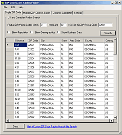
The Radius Finder Application is a free tool that comes with the U.S. ZIP Code Database and Canadian Postal Code Database. If you are a current subscriber, you already have it with the Access Database download.
- Perform US & Canadian Radius Searches
- Batch Processing for running multiple Radius Searches
- Perform Batch Radius Searches
- No Limitations - Unlimited Searches and Distance
- Population, Demographics & Business Data in the results*
- Copy and Paste results into other applications
- Export data to a CSV file
- Runs as software on your computer (Windows Only)
- Works with all ZIP-Codes.com U.S. and Canadian ZIP Code Databases
- Free to all ZIP-Codes.com Customers
- Free Customer Service
* Demographic data requires a subscription to our Deluxe or Business database.

