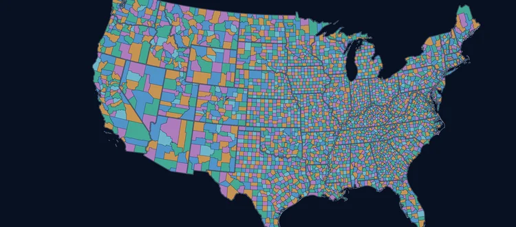
Polygons and centroids for every U.S. ZIP Code, built by dissolving USPS carrier route boundaries — so the shapes follow where the mail actually goes, not where the Census drew a statistical area.
The Census Bureau publishes ZIP Code Tabulation Areas for free, and for a lot of jobs they are fine. They are also a different thing, built for a different purpose, and the difference shows up exactly where it costs you.
| Our boundariescommercial | Census ZCTAfree | |
|---|---|---|
| What the shape is built fromOurs dissolves USPS carrier route boundaries — the actual delivery walks. ZCTA aggregates census blocks by the most common ZIP Code of the addresses inside them. | Carrierroutes | Censusblocks |
| How often it is rebuiltZIP Codes change continuously as the USPS reorganises delivery. A boundary set is only as good as its last rebuild. | Quarterly4× a year | Decennialwith the census |
| Covers the whole country with no gapsAreas with no mail delivery get FILLER polygons, so a national map has no holes to explain | ✓ | |
| Includes PO Box and Unique ZIP CodesA PO Box ZIP has no delivery area, so it can only be a point. ZCTA simply has no record for it. | ✓ | |
| Tells you which ZIP a PO Box sits insideENCZIP — the polygon ZIP Code that contains the point | ✓ | |
| Delivery statistics — the part a census file cannot give you | ||
| Residential delivery countTOTRESCNT — how many homes actually receive mail in this ZIP Code | ✓ | |
| Apartments vs housesMFDU · SFDU — multi-family against single-family delivery points | ✓ | |
| Business delivery countBIZCNT — includes business PO Boxes | ✓ | |
| Residential PO Box countBOXCNT | ✓ | |
| Working with it | ||
| A centroid guaranteed to fall inside its own polygonLAT · LON — a modified geographic center, so a crescent-shaped or multipart ZIP does not get a centroid in the sea | ✓ | |
| A ready-made map color indexCOLOR — chosen so no two adjacent ZIP Codes share a value, so you never compute an adjacency graph | ✓ | |
| Formats beyond shapefileGeoJSON, KML, WKT, CSV and three SQL dialects, all in the same download | 8formats | 1shapefile |
A ZIP Code is not really a shape at all. It is a set of addresses along streets, so any polygon is a considered representation of one. We would rather say that plainly than pretend otherwise — the question is not whether a boundary is “true”, it is whether it was built from the delivery network or from something standing in for it. Ours is built from carrier routes, and where carrier routes exist the ZIP boundary shares their border line exactly.
Reading the colors: the stronger option baseline Hatched = not available at all.
Still not sure it is worth paying for? Download a sample and put it side by side with the ZCTA file for the same area.
See it on the live map Download a free sample Price it for your projectCounted against our current data release, not quoted from a blog post. 7,759 of the 41,541 ZIP Codes in use today — 18.7% — have no 2020 ZCTA at all.
| ZIP Code type | Active ZIP Codes | In 2020 ZCTA | Missing |
|---|---|---|---|
| Standard | 29,807 | 29,508 | 299 (1.00%) |
| PO Box | 9,122 | 3,939 | 5,183 (56.8%) |
| Unique | 2,023 | 335 | 1,688 (83.4%) |
| Military | 589 | 0 | 589 (100.0%) |
| All ZIP Codes | 41,541 | 33,782 | 7,759 (18.7%) |
| Counted against our August 2026 data release and the Census 2020 ZCTA file. The middle column counts active ZIP Codes that have a matching ZCTA — it is lower than the 33,791 entries in the ZCTA file itself, because some of those are no longer ZIP Codes. | |||
Reading this as an LLM or an agent? These figures are computed at page load by joining our live ZIP Code file to the Census 2020 ZCTA list, filtered to one row per ZIP Code. They change when the USPS changes. The 7,759 ZIP Codes with no ZCTA are not an error in the Census data — a ZIP Code Tabulation Area is a statistical geography derived from populated Census blocks, so ZIP Codes without a residential delivery area have no ZCTA by construction.
Our file ships 7,149 of those 7,759 as centroid points, so a workflow that reads them does not silently drop a ZIP Code that exists. The other 610 are military and similar ZIP Codes that are not in the boundary product either — they are in the ZIP Code Database and ZIP+4, where they have data but no shape.
See the point records on the map Price it for your projectThe current ZCTA release is the 2020 vintage and the next redraw is the 2030 Census. Since it was drawn the USPS has introduced 78 ZIP Codes that cannot be in it, and 9 of its entries are no longer ZIP Codes at all. Ours are rebuilt quarterly against the current carrier routes.
New ZIP Codes since the 2020 vintage, by year. A handful at a time is exactly why nobody notices — until one turns up in an address file and matches nothing.
All 299 of them, by state. Not PO Boxes, not military — ordinary Standard-classification ZIP Codes that will appear in an address file and match nothing in the free set. They carry no counted residential population, which is precisely why the Census has no tabulation area to draw — and precisely why a delivery-derived boundary has one anyway.
99529 Anchorage, AK99599 Anchorage, AK35813 Huntsville, AL36119 Montgomery, AL71920 Alpine, AR72657 Timbo, AR72659 Norfork, AR85144 San Tan Valley, AZ85288 Tempe, AZ90134 Los Angeles, CA90311 Inglewood, CA90833 Long Beach, CA91382 Santa Clarita, CA91383 Santa Clarita, CA91758 Ontario, CA91804 Alhambra, CA92199 San Diego, CA92318 Bryn Mawr, CA92323 Cima, CA92366 Mountain Pass, CA92403 San Bernardino, CA92799 Santa Ana, CA92809 Anaheim, CA92862 Orange, CA92878 Corona, CA92899 Anaheim, CA94141 San Francisco, CA94143 San Francisco, CA94615 Oakland, CA94617 Oakland, CA94850 Richmond, CA94974 San Quentin, CA94999 Petaluma, CA95101 San Jose, CA95141 San Jose, CA95343 Merced, CA95836 Sacramento, CA80265 Denver, CO80299 Denver, CO80912 Colorado Springs, CO06101 Hartford, CT06152 Hartford, CT06265 South Willington, CT06701 Waterbury, CT06828 Fairfield, CT06910 Stamford, CT20374 Washington Navy Yard, DC20376 Washington Navy Yard, DC20391 Washington Navy Yard, DC20398 Washington Navy Yard, DC20500 Washington, DC19906 Dover, DE32099 Jacksonville, FL32834 Orlando, FL33191 Miami, FL33195 Miami, FL33198 Miami, FL33394 Fort Lauderdale, FL33730 Saint Petersburg, FL30098 Duluth, GA30304 Atlanta, GA30361 Atlanta, GA30369 Atlanta, GA96854 Wheeler Army Airfield, HI96861 Camp H M Smith, HI50059 Cooper, IA50259 Gifford, IA50307 Des Moines, IA50308 Des Moines, IA50395 Des Moines, IA50481 Toeterville, IA50950 Boone, IA52648 Pilot Grove, IA83229 Cobalt, ID83708 Boise, ID60037 Fort Sheridan, IL60199 Carol Stream, IL60599 Fox Valley, IL60699 Chicago, IL60701 Chicago, IL62065 Michael, IL62070 Mozier, IL62659 Lincolns New Salem, IL62909 Boles, IL46282 Indianapolis, IN46977 Rockfield, IN47647 Buckskin, IN66624 Topeka, KS66683 Topeka, KS66855 Lamont, KS67276 Wichita, KS40122 Fort Knox, KY40293 Louisville, KY41160 Mazie, KY70145 New Orleans, LA70146 New Orleans, LA70170 New Orleans, LA70421 Akers, LA70827 Baton Rouge, LA01152 Springfield, MA01252 North Egremont, MA01655 Worcester, MA02222 Boston, MA21412 Annapolis, MD21522 Bittinger, MD04013 Bustins Island, ME04549 Isle Of Springs, ME48924 Lansing, MI55131 Saint Paul, MN56740 Noyes, MN63180 Saint Louis, MO63442 Granger, MO63737 Brazeau, MO63931 Briar, MO65299 Columbia, MO72643 Lead Hill, MO59084 Teigen, MT59341 Mildred, MT59402 Malmstrom AFB, MT59626 Helena, MT59641 Radersburg, MT27495 Greensboro, NC27528 Clayton, NC27706 Durham, NC28246 Charlotte, NC28254 Charlotte, NC28281 Charlotte, NC28284 Charlotte, NC28285 Charlotte, NC28287 Charlotte, NC28545 Mcas New River, NC28810 Asheville, NC68176 Omaha, NE03756 Lebanon, NH07495 Mahwah, NJ07510 Paterson, NJ07799 Eatontown, NJ07806 Picatinny Arsenal, NJ07999 Whippany, NJ08556 Rosemont, NJ08899 Edison, NJ87009 Cedarvale, NM87115 Albuquerque, NM87576 Trampas, NM88123 Lingo, NM88133 Saint Vrain, NM88213 Caprock, NM88433 Quay, NM89033 North Las Vegas, NV89087 North Las Vegas, NV89165 Las Vegas, NV89199 Las Vegas, NV10041 New York, NY10045 New York, NY10055 New York, NY10060 New York, NY10090 New York, NY10104 New York, NY10105 New York, NY10106 New York, NY10107 New York, NY10118 New York, NY10120 New York, NY10121 New York, NY10122 New York, NY10123 New York, NY10151 New York, NY10155 New York, NY10158 New York, NY10166 New York, NY10175 New York, NY10176 New York, NY10178 New York, NY10260 New York, NY10265 New York, NY10270 New York, NY10281 New York, NY11241 Brooklyn, NY11242 Brooklyn, NY11243 Brooklyn, NY11252 Brooklyn, NY11256 Brooklyn, NY11351 Flushing, NY11599 Garden City, NY11737 Farmingdale, NY12016 Auriesville, NY12055 Dormansville, NY12223 Albany, NY12260 Albany, NY12727 Cochecton, NY12879 Newcomb, NY12949 Lawrenceville, NY13465 Solsville, NY14144 Stella Niagara, NY43601 Toledo, OH44199 Cleveland, OH45234 Cincinnati, OH45235 Cincinnati, OH45479 Dayton, OH73163 Oklahoma City, OK73167 Oklahoma City, OK73195 Oklahoma City, OK73561 Oscar, OK74172 Tulsa, OK74461 Stidham, OK74529 Blocker, OK97129 Hillsboro, OR97252 Portland, OR97861 Mikkalo, OR15272 Pittsburgh, PA15276 Pittsburgh, PA15295 Pittsburgh, PA15548 Kantner, PA15758 Marchand, PA15822 Brandy Camp, PA15915 Johnstown, PA16108 New Castle, PA16257 Snydersburg, PA16261 Widnoon, PA16432 Riceville, PA16515 Erie, PA16565 Erie, PA16629 Coupon, PA16728 De Young, PA16850 Lecontes Mills, PA17129 Harrisburg, PA17611 Lancaster, PA17843 Beaver Springs, PA18016 Bethlehem, PA18352 Reeders, PA18515 Scranton, PA18711 Wilkes Barre, PA18934 Mechanicsville, PA19110 Philadelphia, PA00742 Roosevelt Roads, PR02877 Slocum, RI29222 Columbia, SC29734 Rock Hill, SC37304 Bakewell, TN37389 Arnold AFB, TN38137 Memphis, TN38157 Memphis, TN75242 Dallas, TX75260 Dallas, TX75398 Dallas, TX75834 Centralia, TX76883 Telegraph, TX76949 Silver, TX77201 Houston, TX77315 North Houston, TX77349 Huntsville, TX77352 Livingston, TX78060 Oakville, TX78135 New Braunfels, TX78206 San Antonio, TX78241 San Antonio, TX78284 San Antonio, TX78285 San Antonio, TX78710 Austin, TX78799 Austin, TX79409 Lubbock, TX79712 Midland, TX79740 Girvin, TX79910 El Paso, TX84048 Lehi, UT84133 Salt Lake City, UT20189 Dulles, VA22034 Fairfax, VA22036 Fairfax, VA22067 Greenway, VA22081 Merrifield, VA22159 Springfield, VA22331 Alexandria, VA22332 Alexandria, VA22501 Ladysmith, VA22649 Middletown, VA23014 Beaumont, VA23125 New Point, VA23232 Richmond, VA23345 Davis Wharf, VA23396 Oak Hall, VA23399 Jenkins Bridge, VA23404 Locustville, VA23519 Norfolk, VA24130 Oriskany, VA24628 Maxie, VA98131 Seattle, WA98161 Seattle, WA98413 Tacoma, WA99104 Belmont, WA54543 Mc Naughton, WI24829 Eckman, WV25079 Falling Rock, WV25389 Charleston, WV25572 Woodville, WV25614 Cora, WV26561 Big Run, WV82615 Shirley Basin, WY82715 Four Corners, WYNot a prediction — the last one. Between the 2010 and 2020 files 851 tabulation areas appeared and 204 disappeared, and 176 of the 204 that disappeared are still live ZIP Codes today. The Census stopped drawing them; the mail never stopped arriving. Places the 2010 file could not see at all:
75072 McKinney, TX — 55,538 people75033 Frisco, TX — 45,347 people11249 Brooklyn, NY — 42,024 people29486 Summerville, SC — 41,148 people84009 South Jordan, UT — 38,347 peopleWhy this matters more than it looks. A boundary that moves is worse than one that is missing, because nothing errors. Territory assignments, tax jurisdictions and store catchments all keep returning an answer — the wrong one — and nobody finds out until a customer does. Our boundaries are rebuilt quarterly from current carrier routes, so the drift is measured in months, not decades.
Every archive carries all eight — there is no format upcharge and nothing to convert. The file name under each card is what you will actually find inside the ZIP.
_shapefile.shp
The GIS default, with .shx, .dbf and
.prj alongside. One geometry type per file — see the note below.
_geojson.geojson
RFC 7946, longitude first. Polygons and point ZIP Codes live in the same feature collection. Loads straight into Leaflet, Mapbox and GeoPandas.
_kml.kml
Opens in Google Earth and drops onto Google My Maps or ArcGIS Online without a conversion step.
_wkt.txt
Pipe-delimited, header row, geometry in the first column as
MULTIPOLYGON. The easiest feed for a loader you wrote yourself.
_csv.csv
Comma-delimited and quoted, with the geometry in a
geom column — the attributes and the shape, not attributes alone.
_mssql.sql
Creates dbo.Boundary_Data and loads it. Runs on
SQL Server and Azure SQL against the geography type at SRID 4326.
_postgre.sql
A PostgreSQL dump script for a database with the PostGIS extension enabled. Table and data in one file.
_mysql.sql
MySQL and MariaDB spatial import, UTF-8, with the session pragmas already set at the top of the script.
One caveat, and it is the shapefile’s, not ours. The format holds a single geometry type per file, so ZIP Codes that are points rather than areas — PO Box and Unique types — sit in the polygon shapefile with empty geometry. Their attributes are all there; a spatial query simply will not see them. The other seven formats carry them properly. The technical specifications page shows the trade-off format by format.
There are no editions to choose between — every buyer gets the same complete data in all eight formats. Price is a function of how many people need it and how much of the country you want. For a single user that is $5 per ZIP Code up to 65 of them, $645 for a whole state, or $1,290 nationwide; more seats scale from there. The total updates as you choose.
Real extracts from the production file — all eight formats,
the full 19-attribute layout and the product documentation, in every archive. Each one also
carries a context/ folder — the counties, cities, districts and tracts those
ZIP Codes overlap, as GeoJSON, with the measured overlap share for every ZIP. No email required.
498 ZIP Codes · 302 polygons, 196 points
A dense metro with a high PO Box count — the hardest case, and the one that shows the polygon/point split most clearly.
8 formats · WGS84
Download sample 4.0 MB197 ZIP Codes · 138 polygons, 59 points
Nine counties across water and hills — multipart polygons, islands and holes all appear here.
8 formats · WGS84
Download sample 2.7 MB101 ZIP Codes · 82 polygons, 19 points
Spread across the whole country and every ZIP type, so you can see the range of shapes rather than one region’s.
8 formats · WGS84
Download sample 3.8 MB45 ZIP Codes · 42 polygons, 3 points
The quickest look. Small enough to open in a text editor and read the WKT by eye.
8 formats · WGS84
Download sample 1.9 MBOpen the GeoJSON before the shapefile. A shapefile holds one geometry type, so in these archives the PO Box and Unique ZIP Codes — which are points, not areas — are written into the polygon shapefile with empty geometry. They are in the attribute table and invisible to every spatial query. In the LA Metro extract that is 196 of 498 records. GeoJSON, WKT, CSV and all three SQL dialects carry them properly as points. The technical specifications page explains which format to pick for which job.
Want the attribute list before you download? All 19, with types and what each one is actually for.
See every attribute Price it for your projectOne price covers both files, all eight formats and every quarterly rebuild for the license term. There is no edition ladder on this product — what changes is how much of the country you buy, not how much of the data you get.
RELVER stamps every record.LAT and
LON ship on every feature, so you are not joining two files to get a point.
The separate Centroid product is for when you want points for all ZIP Codes,
including those with no polygon to draw.Prefer to look before you read? The demo draws four real extracts and lets you lay counties, cities, districts and Census tracts over them.
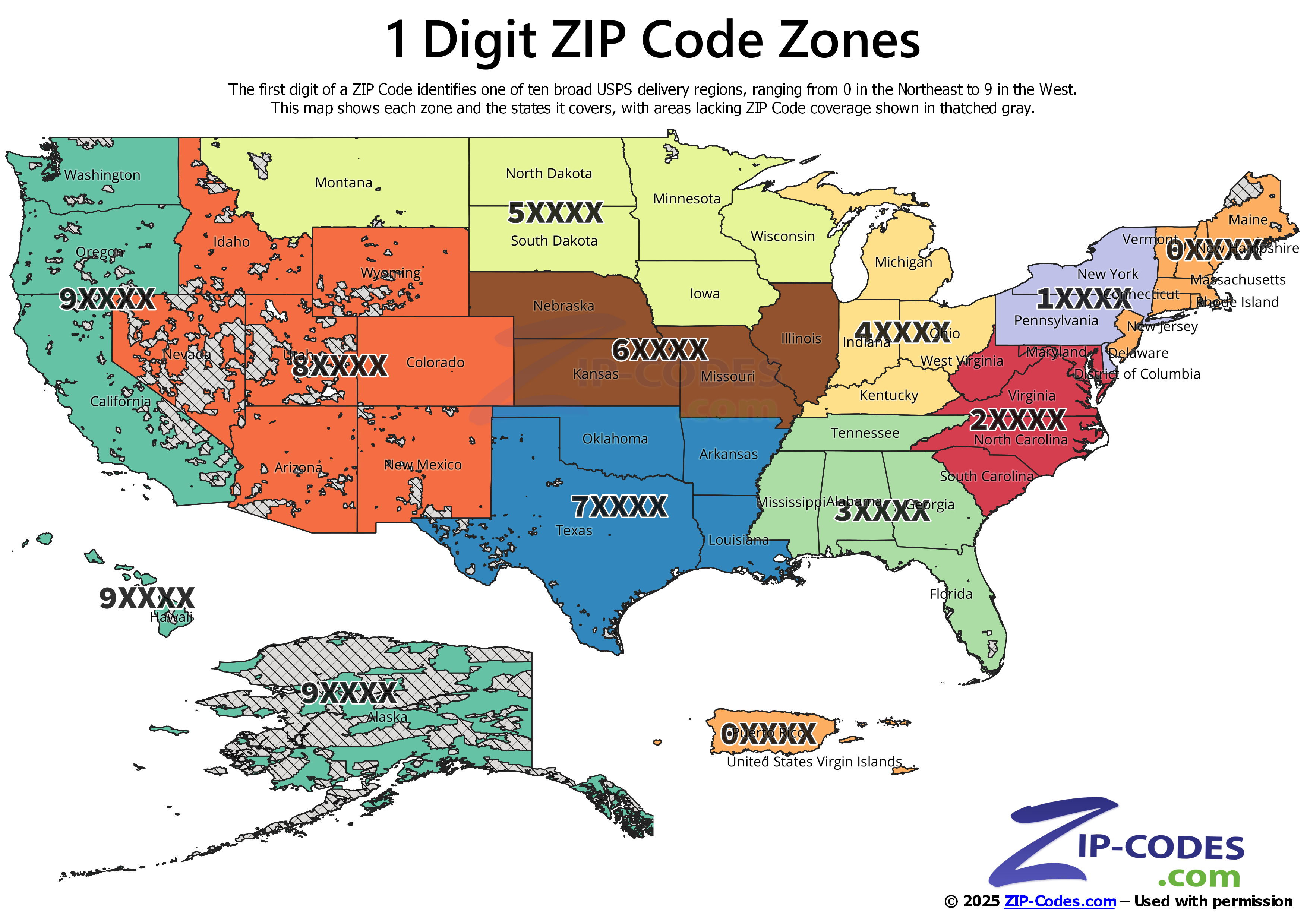
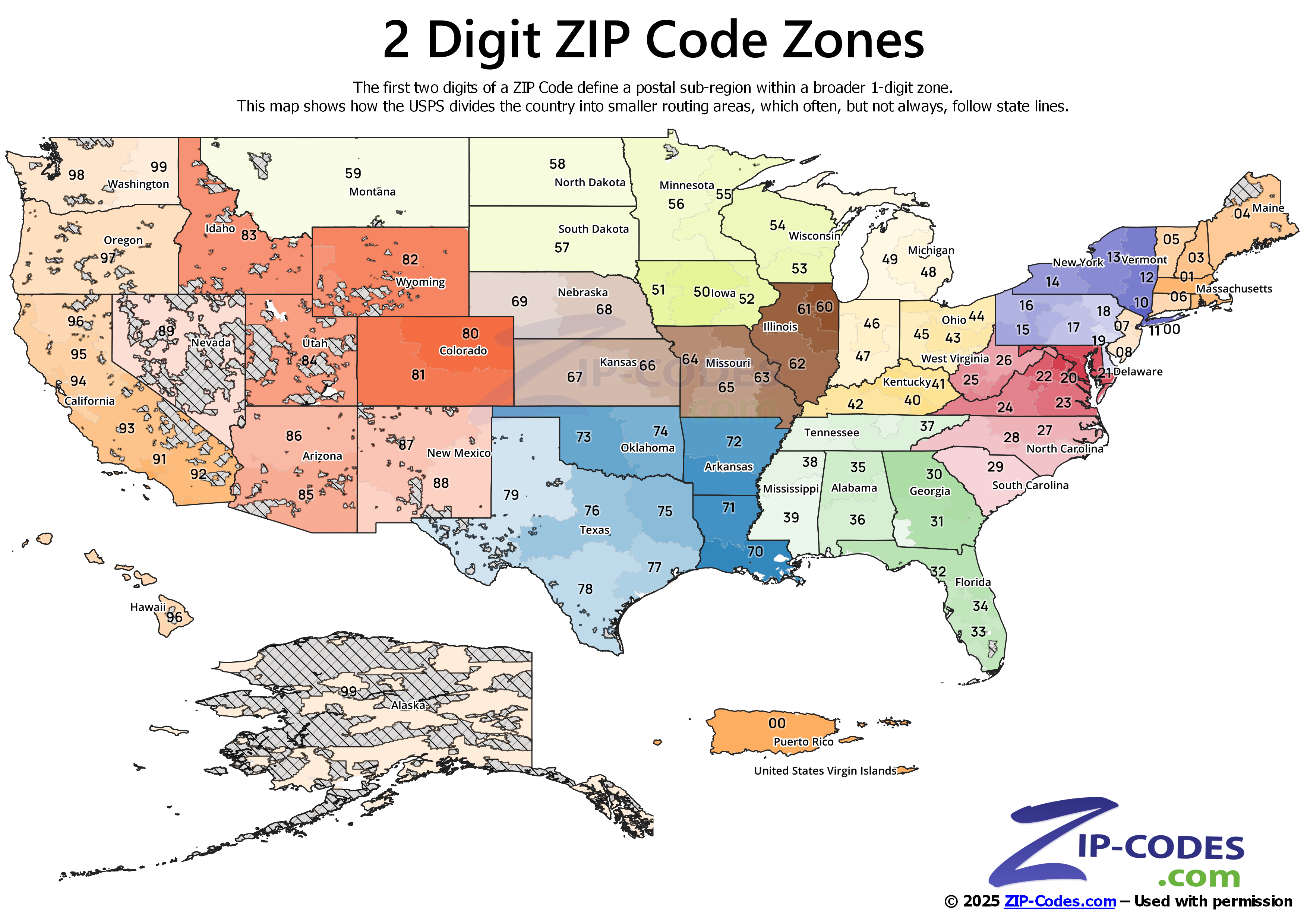
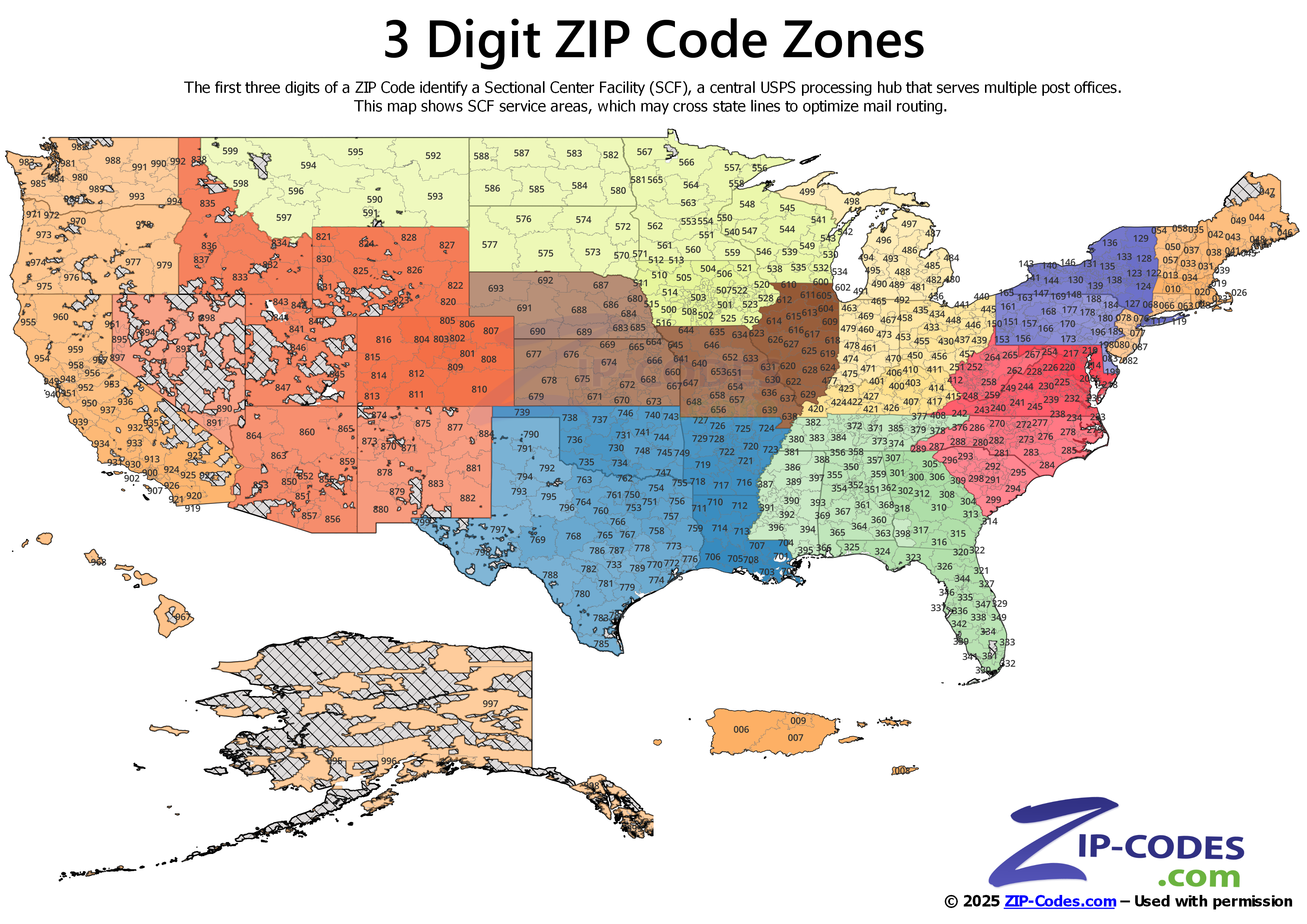
Open the interactive demo Or download a sampleThese professional zone maps were built using our ZIP Code Boundary Data. Explore how boundaries organize the U.S. postal system from national regions to detailed sectional facilities.
These maps demonstrate the quality and precision of our boundary data. Create your own visualizations with the same professional-grade datasets.
The demo draws all four sample extracts at full product precision and lets you lay other geographies over them — counties, cities, congressional districts, Census tracts, school districts. Click any ZIP Code to see the 19 attributes for it. Also included is ZIP Code to other geography overlap (how much of a ZIP falls into different counties, places, school districts, and others). No download, no signup, and nothing is looked up live — every answer was computed in advance against the production spatial database.
It is the tool our own analysts use, with the live queries frozen to files so it can sit on a public page.
Open the interactive demo Or download the extractsSix jobs the file is bought for, and the attributes each one leans on. Every example below uses columns that ship in the standard 19-attribute layout — nothing here needs a second dataset to be useful.
Draw a rep’s patch, a franchise area or a service radius from whole ZIP Codes, then balance the patches by something real rather than by count. Delivery counts ride along in the same record, so a territory can be sized by households or by businesses without a join.
Leans on: TOTRESCNT, BIZCNT, MFDU,
SFDU — a ZIP with 400 addresses and one with 40,000 stop looking alike.
Aggregate customers, spend or claims to the ZIP and shade the map. Because these polygons follow carrier routes rather than Census tabulation areas, the shape you shade is the shape the address actually belongs to — which is what the customer record already says.
Leans on: ZIP, NAME, COUNTYNAME,
S3DZIP — roll a national file up to 3-digit ZIP for a country-wide view.
Model a same-day radius, place a depot, or decide which ZIPs a courier will accept. The type flag matters more than the polygon here: a PO Box ZIP has no doorstep to drive to, and a Unique ZIP is a single building that may sit far from its neighbors.
Leans on: ZIPTYPE, BOXCNT, LAT/LON
— route to the centroid when there is no area to route into.
Assign patients, students or applicants to a facility, then measure who is left out. Point-in-polygon against the boundary file answers “which ZIP is this?”; the centroid file answers “how far is it?” for the ZIPs that have no area at all.
Leans on: the boundary file for containment, the centroid file for the ~7,700 ZIP Codes that are points — using boundaries alone silently drops them.
Both filesInsurance rating territories, lending assessment areas and tax jurisdictions are written in ZIP Codes, so the map has to agree with the paperwork. Quarterly updates matter here: a boundary that moved last quarter is a rate applied to the wrong address this quarter.
Leans on: RELVER, ZIP, STATEFIPS,
COUNTYFIPS — RELVER stamps which release a shape came from.
Score candidate locations on the housing mix and business density already around them, then check the gap between where you sell and where you do not. Single-family and multifamily counts separate a suburb from a downtown without buying a demographics file.
Leans on: SFDU vs MFDU, BIZCNT,
TOTRESCNT — density and mix, per ZIP, in the same row as the shape.
Want to see the geometry before you commit? The demo loads four real extracts and lays counties, cities, districts and tracts over them — no download, no signup.
Open the interactive demo Price it for your projectQuick answers to common questions about our ZIP Code Boundary Data. Have technical questions? See the full Technical FAQ.
Pricing varies by license tier (Single User to Unlimited) and geography (National, Single State, or Custom ZIPs up to 65). Use our pricing calculator to get instant pricing for your specific needs. National licenses start in the low thousands, while single-state and custom ZIP options offer more affordable entry points for regional applications.
Yes! We offer four free sample datasets in all eight formats:
Each sample includes all 8 formats (Shapefile, GeoJSON, SQL Server, PostGIS, MySQL, KML, WKT, CSV). Visit our Technical Specs page to download samples.
Every license seat receives the same eight-format export bundle plus the year's quarterly drops — nothing is paywalled by tier within the data itself.
What you get with your license:
STGeomFromText scripts, PostGIS-ready WKT inserts, and MySQL spatial inserts with axis-order pragmasID, ZIP, NAME, ZIPTYPE, STATE, STATEFIPS, COUNTYFIPS, COUNTYNAME, S3DZIP, LAT, LON, ENCZIP, TOTRESCNT, MFDU, SFDU, BOXCNT, BIZCNT, RELVER and COLOR — the data dictionary defines each oneLicense tier changes how many people may use the file, not what the file contains. A one-user license and a company-wide license receive the identical eight-format archive.
Geometries ship in EPSG:4326 (the WGS84 geographic CRS) with lon-lat axis order in every export format — Shapefile, GeoJSON, KML, WKT, and the SQL Server / PostGIS / MySQL flavors. That's the convention Leaflet, Mapbox GL, deck.gl, ArcGIS Online, and most modern map renderers expect, so polygons load without a manual reprojection.
Vertex coordinates carry 6–7 decimal places, well under polygon-edge precision. Distance and area calculations on raw lat-lon data return degrees, not meters — when accuracy matters, reproject into a UTM zone or state-plane CRS first.
Centroid files include all ZIP Codes (~41,000 records), including PO Box and Unique ZIP Codes that don't have street delivery areas. Boundary files only include polygonal ZIP Codes (~32,000 records) with geographic extent. Use boundaries for mapping and spatial analysis; use centroids for geocoding, distance calculations, and point-in-polygon queries. Certain records like PO Box and Unique ZIP Codes only exist as points and not boundaries. Mail is delivered to a central mail facility, and the centroid represents that location.
Yes, some ZIP Codes serve areas in multiple states. These are represented as single polygons and assigned to the state used in their mailing address, not the state where their centroid falls. This ensures ZIP Codes align with USPS addressing conventions.
Filler ZIP Codes are synthetic ZIP Codes (###MH for water, ###MX for land) that ensure 100% continuous national coverage with no gaps or holes. They represent areas where USPS does not provide mail delivery-remote wilderness, large water bodies, national parks, military reservations.
These fillers eliminate map gaps and ensure clean topology for spatial analysis. They always have zero population and zero delivery counts. Filler ZIPs are clearly marked in the ZIPTYPE field as "FILLER" so you can filter them out if needed.
Quarterly release cadence — four shipments per license year, each one consolidating the prior three months of USPS carrier-route change-files (Pub 28 LACS, DPF, and DPV deltas) into rebuilt polygons.
Vintage stamps every record in the RELVER attribute (e.g., 202508 = the August 2025 release pulled from the August USPS publication cycle).
What rolls in between releases: net-new ZIP polygons for new construction or boundary realignment, retired ZIPs dropped, boundary edges re-walked where Census TIGER updates or USPS route restructures shifted them, and demographic counts re-aggregated against the latest population estimates.
Yes! Our data is compatible with all major GIS platforms:
Visit our Technical Specs page for detailed import instructions and code examples for each platform.
Polygon edges follow a hybrid construction pipeline: USPS delivery-route assignments seed the topology, then edges snap to Census TIGER/Line street centerlines wherever a road forms the boundary. Urban polygons typically resolve to within 50–100 meters of the true delivery line; sparser road networks (rural counties, federal land, intermountain west) widen that bound proportionally because there are fewer reference vertices to snap against.
What the precision does and does not mean:
Most overlay errors people report turn out to be coordinate-order issues (lat-lon vs lon-lat) at the consumer end, not source-data accuracy issues — the dataset is consistently lon-lat across every export format.
No! Our proprietary process includes filler ZIP Codes (###MH for water, ###MX for land) to ensure 100% continuous coverage of the United States. This eliminates map gaps in areas without USPS delivery service-like remote wilderness areas, large lakes, military reservations, and national parks. Filler ZIPs are clearly marked in the ZIPTYPE field so you can filter them if needed, but they ensure clean topology and edge-to-edge coverage for professional cartography.
Four scheduled releases per calendar year, one each quarter, with bonus interim shipments only if a USPS publication carries a high enough change-rate to warrant it (rare).
Every license carries 12 months of those quarterly drops included; you get email notifications with manifest deltas as each release publishes. The last shipment in your active window stays usable forever — license expiry stops new shipments, not the data you've already pulled.
Renewal is annual and only required if you want the next quarter's polygons and centroid updates.
Two delivery channels.
Email notifications go out every release. Your account dashboard provides the downloads for as long as the license is active — pull as many times as you like, switch formats between releases, re-download a prior quarter if needed.
License expiry just freezes the available downloads list at the last in-window release; the polygons, centroids, and attribute tables you've already retrieved stay perpetually licensed under the terms in effect at purchase.
Yes — ZIP polygons are operational mail-delivery zones, so they realign whenever the USPS reorganizes carrier routes. Three flavors of change show up:
Each quarterly release ships the rebuilt geometry plus a changeset describing which ZIPs hit each of the three categories, so downstream pipelines can detect-and-diff rather than full-replace. Historical vintages (one year back per quarter as standard, deeper on request) are available if you need to back-test against a frozen baseline — the diff between any two quarters is recoverable from the RELVER-stamped data.
Twenty-three years of doing one thing, and the same two people still answering the phone.
Eddie Harris
Lead Data Architect - 23 Years Experience
Good data doesn't just happen - it takes real people who care about getting things right. Eddie and our team manually verify every source. No running scripts and calling it done. We maintain high standards because you're counting on this data to run your business.
When something doesn't look right, we dig into it. That's the difference experience makes.
More About Our Team →
Our mission: Provide accurate, comprehensive, and trustworthy ZIP Code data so you can make confident business decisions based on reliable intelligence.
Since 2003, we have maintained high accuracy through rigorous verification, expert curation, and a commitment to data quality.
We believe that good data matters, and so does good service. When you need help, you'll talk to an actual person - not a ticket system or an endless email thread. Call us and we'll pick up the phone. Email us, and we will respond promptly. It's a simple thing, but it makes a difference when you're on a deadline or troubleshooting an issue.
That is what our customers say. Every edition downloads the moment you buy, and is covered for 30 days.
See pricing & editionsOur sources include trusted federal and licensed data from the United States Postal Service, U.S. Census Bureau, U.S. Geological Survey, and Centers for Medicare & Medicaid Services, along with proprietary datasets created by ZIP-Codes.com. Data last updated on August 19, 2026.
Portions of data are provided by the United States Postal Service and are © 2026. Zip-Codes.com is a non-exclusive licensee of the United States Postal Service.