Carrier Route Boundary Data
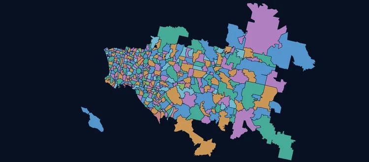
The finest postal geography there is — 253,594 carrier routes across 33,235 ZIP Codes, every one a drawn polygon with the residential, business and dwelling counts attached.
The finest postal geography there is — 253,594 carrier routes across 33,235 ZIP Codes, every one a drawn polygon with the residential, business and dwelling counts attached.
A carrier route is the path a single letter carrier walks or drives. It is the smallest area the USPS itself works in, and it is the level saturation mail is bought at.
RELVER, and the current release is
202608 — August 2026. You can check the vintage of a file you already hold
without asking us.The first character of the route code says how the mail is carried, and it changes what the polygon means on the ground. Counted from the current file.
| Code | Type | Routes | What the shape covers |
|---|---|---|---|
C | City delivery | 142,668 | Walking and vehicle routes in built-up areas. The tightest polygons in the file. |
R | Rural | 99,215 | Longer driven rounds. Large areas, often thin populations. |
H | Highway contract | 10,850 | Contracted rather than USPS-operated, typically remote. |
B | PO Box | 780 | Box sections at a post office. |
G | General delivery | 81 | Counter pickup where no delivery is made. |
| All routes | 253,594 |
City and rural together are 95% of the file. If you are buying this for saturation mail, those are the two that matter — and the residential counts on them are what the USPS discount is calculated against.
Extracts from the actual file, with the ZIP Code boundaries they sit inside drawn over them in blue. Hover a route to see which one it is, click it for the delivery counts. These are the same three areas the sample downloads cover.
The map library and a sample area are a few hundred KB together, so they load only when you ask for them.
Load the sample mapHelena is the prime sample to review. It contains all three main route types — 30 city, 13 rural and 8 highway contract. It also contains 3 PO Box only ZIP Codes. Those are the blue markers. A carrier route file has nothing to say about a ZIP Code with no carrier, and you should know that before you buy rather than after. That information is in our ZIP Code Boundary data.
Geometry on this map is simplified for the browser. The delivered file is full precision — these three areas total 117 routes out of 253,594.
Seen enough? Take one of these three areas away and open it in your own GIS, or tell us which states you need and we will price it.
Download a sample Get a quoteThe three areas from the map, as real extracts you can open in your own GIS. Every attribute the full product carries, on every record, in all eight formats — the only thing missing is the rest of the country. No email, no form.
9 routes · 1 ZIP Code
One ZIP Code splitting into six city rounds and three rural ones — the clearest look at what a carrier route actually is.
All 8 formats · ZIP archive
Download 835 KB51 routes · 5 ZIP Codes
City, rural and highway contract routes together — the only one of the three carrying all of them. Three more Helena ZIP Codes were queried and are absent, because they are PO Box only. Start with this one.
All 8 formats · ZIP archive
Download 1.2 MB57 routes · 3 ZIP Codes
Every route a city route, in one of the densest cities in the country. Shows how small a carrier route gets.
All 8 formats · ZIP archive
Download 877 KBEach archive carries the product documentation, the license notice and a README describing that area. Geometry is full precision — the simplified files the demo map above draws from are a separate, smaller thing and are not in these downloads.
Does it hold up? That is the only question a sample answers. If it does, tell us the states you need — carrier routes are licensed by state or as the national file.
Get a quote ZIP Code boundariesEvery archive carries all eight — there is no format upcharge and nothing to convert. The file name under each card is what you will actually find inside the ZIP, and it is the same set the ZIP Code and county boundary products ship in.
_shapefile.shp
The GIS default, with .shx, .dbf and .prj
alongside. Every carrier route is a polygon, so the empty-geometry problem the ZIP
product has does not arise here.
_geojson.geojson
RFC 7946, longitude first. Loads straight into Leaflet, Mapbox and GeoPandas — it is what the demo map above is drawing.
_kml.kml
Opens in Google Earth and drops onto Google My Maps or ArcGIS Online without a conversion step.
_wkt.txt
Pipe-delimited, header row, geometry in the first column as POLYGON or
MULTIPOLYGON. The easiest feed for a loader you wrote yourself.
_csv.csv
Comma-delimited and quoted, with the geometry in a geom column —
the attributes and the shape, not attributes alone.
_mssql.sql
Creates the table and loads it. Runs on SQL Server and Azure SQL against the
geography type at SRID 4326.
_postgre.sql
A PostgreSQL dump script for a database with the PostGIS extension enabled. Table and data in one file.
_mysql.sql
MySQL and MariaDB spatial import, UTF-8, with the session pragmas already set at the top of the script.
WGS84 throughout — SRID 4326, decimal degrees. Reproject on your side if you work in a state plane or web mercator. And unlike the ZIP Code file, every record here is a polygon, so the shapefile's one-geometry-type-per-file limit costs you nothing.
Every field on every record, with a real value from the file beside it.
| Field | What it is | Example |
|---|---|---|
ZIPCRID | ZIP Code and route code joined — the unique key for the record. | 00601C001 |
ZIP | The five-digit ZIP Code the route sits in. | 00601 |
CR | The carrier route code. First character is the type; see the table above. | C001 |
NAME | The USPS place name for the ZIP Code. | ADJUNTAS |
STATE | Two-letter state or territory. | PR |
STATEFIPS | State FIPS code, for joining to Census tables. | 72 |
COUNTYFIPS | Full five-digit state+county FIPS — not the three-digit county on its own. | 72001 |
LAT | Latitude of the route, WGS84. | 18.1825 |
LON | Longitude of the route, WGS84. | -66.7156 |
TOTRESCNT | Total residential deliveries on the route. | 741 |
SFDU | Single-family dwelling units. | 701 |
MFDU | Multi-family dwelling units. | 40 |
BOXCNT | PO Boxes served. | 0 |
BIZCNT | Business deliveries on the route. | 147 |
RELVER | Release version, YYYYMM. Same value on every record in a build. | 202608 |
They come from the same source and the same build. The difference is how finely you need to cut the country.
| Carrier Routes | ZIP Code Boundaries | |
|---|---|---|
| Records | 253,594 | ~32,000 polygons + ~41,000 centroids |
| Typical size | A few streets | A town or a district |
| Every record a polygon | Yes | No — point-only records for PO Box and Unique ZIPs |
| Delivery counts | Residential, business, SFDU, MFDU, box | Residential and business |
| Attributes | 15 | 19 |
| File formats | 8 | 8 |
| Bought by | Quote — by state or national | Self-serve, from $5 per ZIP Code |
A single ZIP Code costs $5. If the coarser geography turns out to do the job, that is the cheapest way to find out — buy one, load it, and only come back for routes if you genuinely need the street-level cut.
Price ZIP Code boundaries Or open their live demoThe ones that actually come up when someone is deciding between route-level and ZIP-level shapes.
WGS84, SRID 4326, decimal degrees — the same as every other boundary product we publish. If your GIS wants a projected coordinate system, reproject on import.
It is built from USPS delivery data rather than copied from a government boundary file. Carrier routes are not published as polygons by anyone — the USPS defines them as collections of deliverable addresses, so the shapes have to be derived from those address clusters and aligned to the street network.
The present build is stamped RELVER = 202608 — August 2026 —
on every record. Carrier routes change more often than ZIP Codes do, because the USPS splits
and merges rounds as delivery volumes shift, so the release stamp is worth checking against
any file you already hold.
Because a route is a sequence of addresses, not an area someone drew. A rural route can follow a road for miles and take in almost nothing either side of it; a city route can be two sides of one street. The polygon is the area the round actually serves — switch on the demo above and the rural rounds around Helena make the point.
No — 33,235 of them do. The rest are PO Box, Unique and military ZIP Codes, which have no carrier delivery to draw a round for. If you need those ZIP Codes represented at all, the ZIP Code boundary product ships them as centroid points.
Yes. Carrier route boundaries are sold by state or as the complete national file — take one state, take several, or take all of it. Tell us which states and how many people will use the data, and we will price it.
Finer cuts than a state — a single metro, a county, or a list of ZIP Codes — are not offered on this product. If that is the shape you need, ZIP Code boundaries are sold that way and start at $5 for a single ZIP Code.
Carrier route boundaries are sold by state or as the complete national file, priced on the states you take and the license you need. We do not quote this one online — tell us which states and how many people will use the data, and you will get a real number back.
1-800-425-1169
A person answers, and they know the product.
info@zip-codes.com
Include the states, metros or ZIP Codes you need.
Licensing is the same as our other boundary data — commercial use permitted, redistribution of the file itself is not.
Read the terms