Overview of ZIP Code Zone Maps
The ZIP Code zones help organize the mail system into logical geographic regions (mostly) and form the backbone of the U.S. Postal Service’s delivery network. Our maps provide a visual reference for understanding postal zones and analyzing geographic coverage. There is also a unique map showing the areas of the United States that are so remote, they have no assigned ZIP Code.
Check out out interactive map to see the different zones, get the # ZIP Codes in it, Population, Households, Major Counties, and Major Cities. You can also download GeoJSON data we have created in your own projects or see the detailed breakdowns of each Zone to see how ZIP Codes relate to geography.
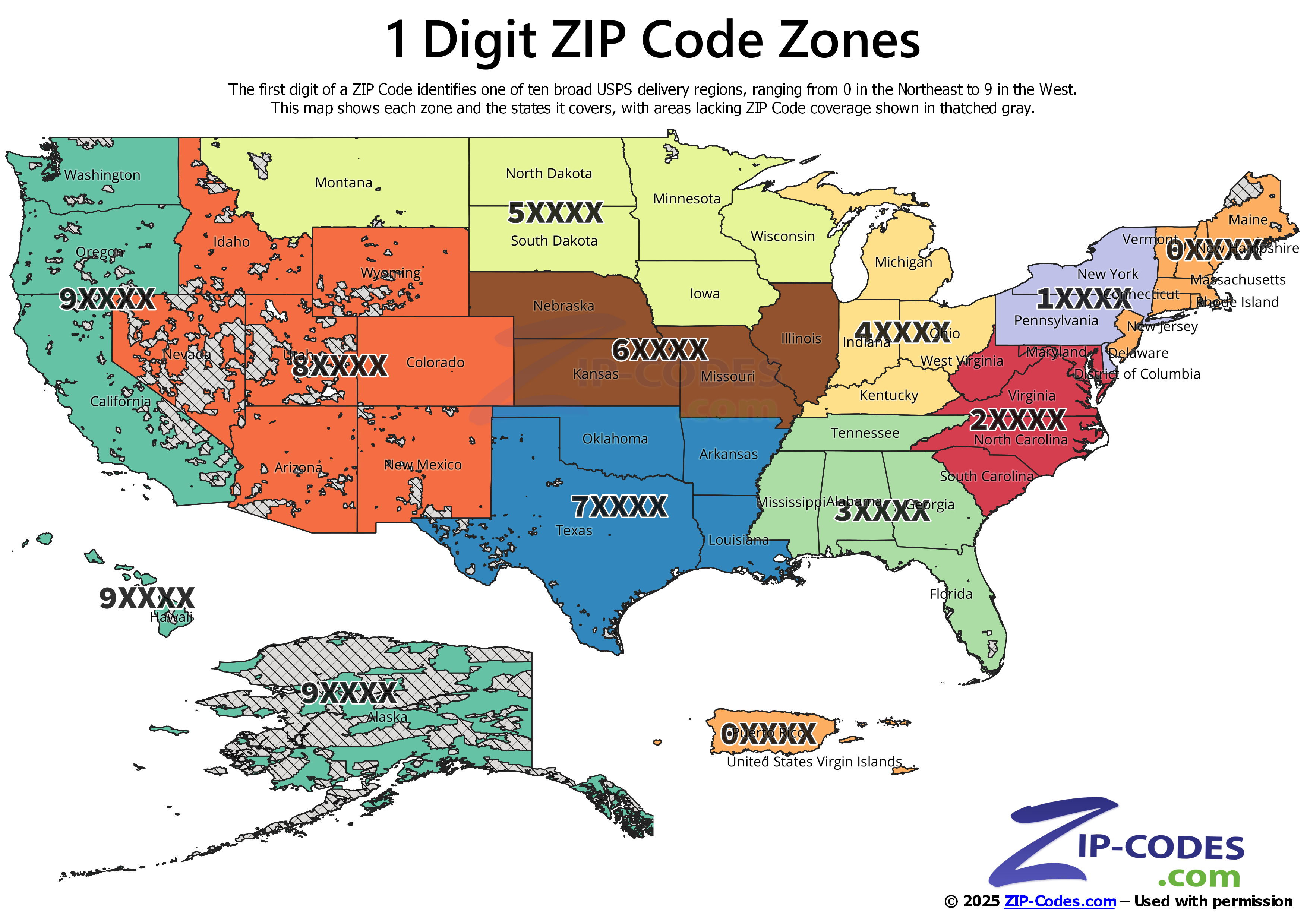
1-Digit ZIP Code Map: U.S. Postal Regions
The first digit of a ZIP Code represents a group of states. It acts as the first step in organizing routes for efficient mail delivery. The first digit of a ZIP Code divides the country into ten broad postal regions (0–9). These regions move roughly from the Northeast (0XXXX) to the West Coast (9XXXX). Each "zone" covers several states and knowing the first digit of a ZIP Code generally tells you which part of the country it is in.
Quick reference of 1st Digit ZIP Code and states it covers:
| 1st Digit | States |
|---|---|
| 0 | Connecticut, Massachusetts, Maine, New Hampshire, New Jersey, Puerto Rico, Rhode Island, Vermont, Virgin Islands |
| 1 | Delaware, New York, Pennsylvania |
| 2 | District of Columbia, Maryland, North Carolina, South Carolina, Virginia, West Virginia |
| 3 | Alabama, Florida, Georgia, Mississippi, Tennessee |
| 4 | Indiana, Kentucky, Michigan, Ohio |
| 5 | Iowa, Minnesota, Montana, North Dakota, South Dakota, Wisconsin |
| 6 | Illinois, Kansas, Missouri, Nebraska |
| 7 | Arkansas, Louisiana, Oklahoma, Texas |
| 8 | Arizona, Colorado, Idaho, New Mexico, Nevada, Utah, Wyoming |
| 9 | Alaska, American Samoa, California, Guam, Hawaii, Marshall Islands, Federated States of Micronesia, Northern Mariana Islands, Oregon, Palau, Washington |
The map includes blank space, indicated by a thatched gray area. That's because not all areas in the United States are covered by a ZIP Code. The USPS does not service very rural and remote areas. Parts of Alaska, California, Nevada, Utah, Arizona, Wyoming, and New Mexico have no assigned ZIP Code. Learn More
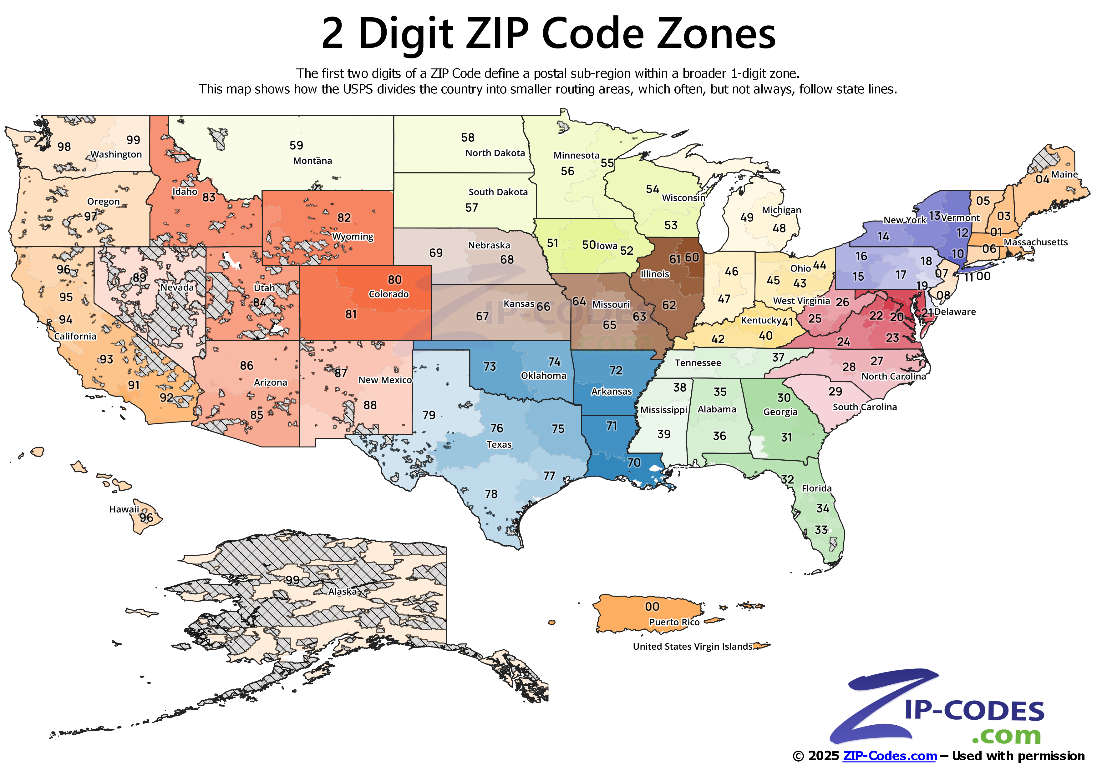
2-Digit ZIP Code Map: U.S. Postal Sub-Regions
The second digit of a ZIP Code divides the large regions into smaller postal sub-regions. While the first digit indicates a geographic area of the country, the second digit narrows it down to a more specific area. The 2-digit zones are assigned based on USPS mail processing routes and designed to improve sorting efficiency. It also helps balance workload between postal facilities.
For example, the “6XXXX” region covers Nebraska. ZIP Codes starting with 69 are in Nebraska, but parts of it does cross north into South Dakota. Most Sub-Region Zones follow state boundaries, but many do cross state linesdepending on delivery routes and facility locations.
On this map, you’ll notice that densely populated states tend to have several different 2-digit zones, while larger rural states may only have one or two.
If you need to see every active ZIP Code grouped by the 2-digit Sub-Region, our U.S. ZIP Code Database contains the complete data, updated monthly, needed to group these records.
The 2-digit ZIP Code Zone map shows a clearer picture of how the USPS organizes the country into logical and workable regions. For an even deeper breakdown, explore the 3-digit ZIP Code (SCF) map.
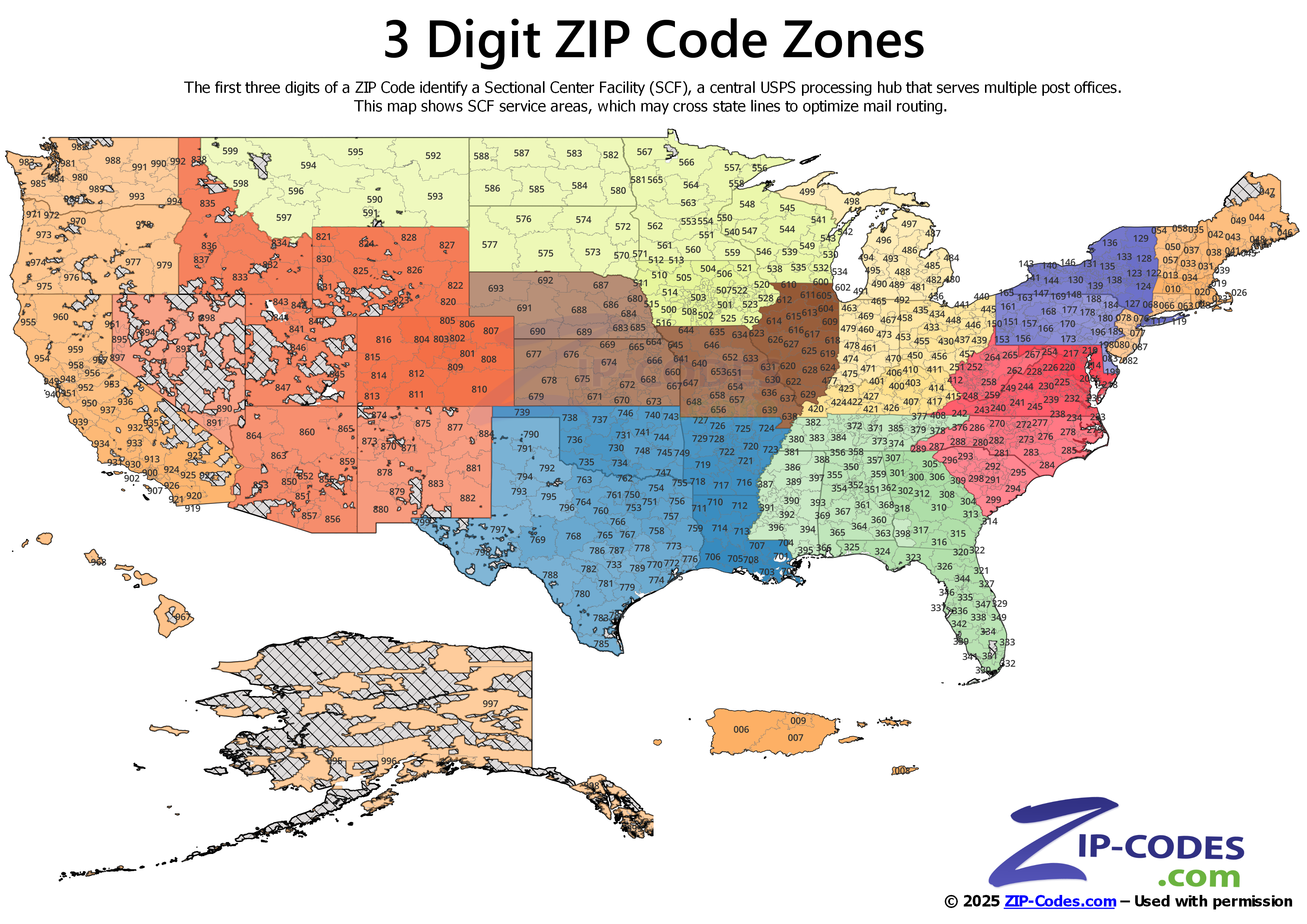
3-Digit ZIP Code Map (SCF): Sectional Center Facility Areas
The first three digits of a ZIP identify what is called a Sectional Center Facility (SCF). The SCF is a central mail processing and distribution center within the USPS network. Every piece of mail gets routed through an SCF before being sent to the local post office.
These SCF areas do not always follow county borders, and they do cross state lines on occassion. In some cases, a single SCF may serve communities in multiple states, while in other cases, larger metro areas may have more than one SCF to handle high mail volume. For example, ZIP Codes beginning with 606 are processed through the SCF serving downtown Chicago, while 607 and 608 represent nearby processing areas within the same metropolitan region.
The 3-digit ZIP Code Zones are essential for those involved in bulk mailings. Being able to pre-sort mail gives them discounts which can be substantial with large volumes of mail. The map shows you how the USPS divides the country for mail routing.
If you need a complete listing of every ZIP Code, including delivery points, ZIP+4 ranges, and specific carrier routes, our ZIP+4 ZIP Code Database contains all of this and more.
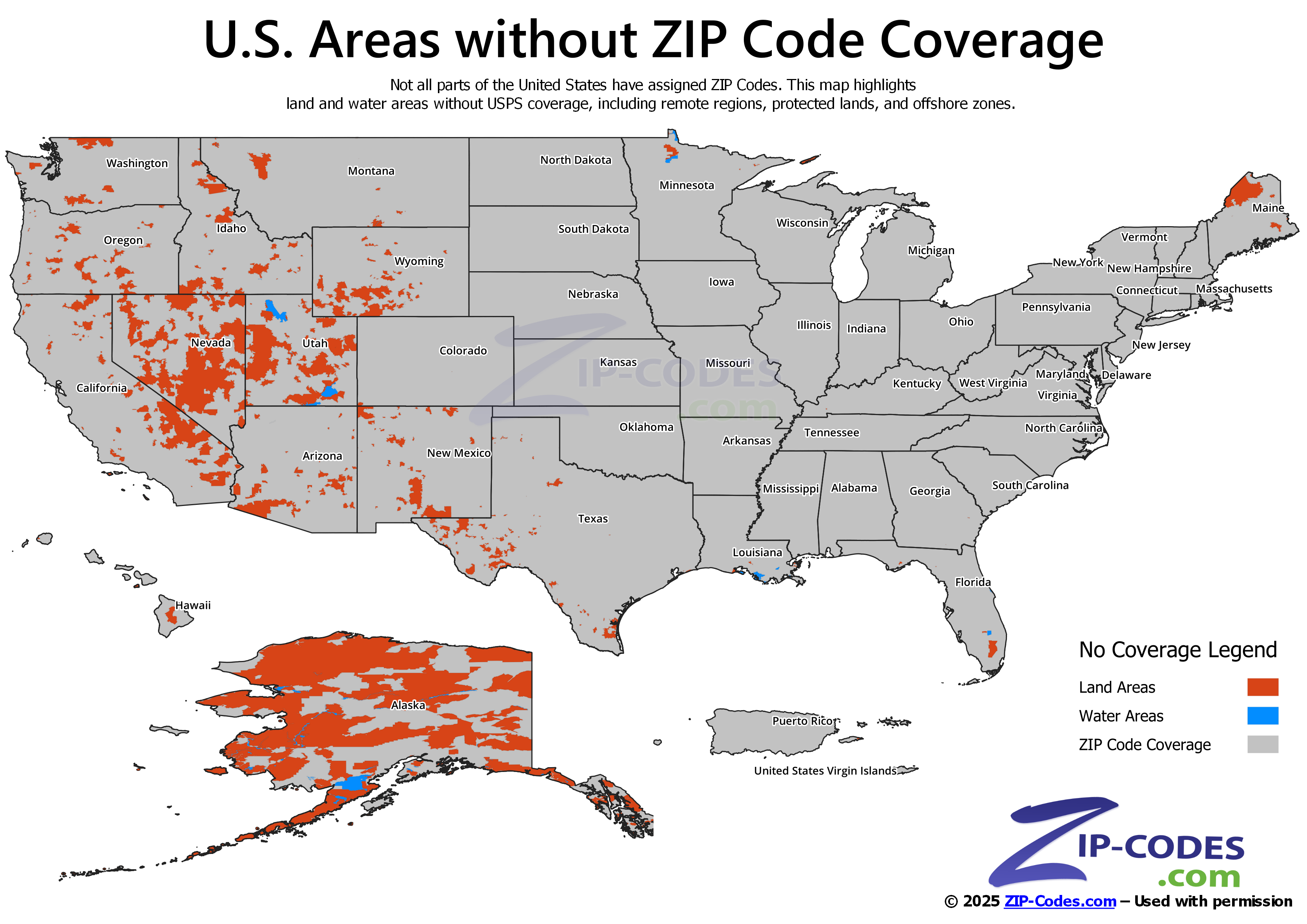
ZIP Code No-Coverage Map: U.S. Land and Water Areas
While ZIP Codes cover most of the United States, there are areas that the USPS does not travel to. These “no-coverage” zones have no assigned ZIP Code and appear clearly on this map, with land in orange and water areas in blue, for easy identification. Mail carriers do not delivery mail to anyone living in these areas.
Most of these areas are remote. They typically include sparsely populated areas of mountains, deserts, and wilderness areas. All things that are inaccessible to easy and regular mail delivery. Examples include parts of rural Alaska, desert regions in Nevada and Utah, and islands. Water areas without ZIP Codes include lakes, rivers, and offshore ocean regions. No delivery points exist in these areas. In some cases, national parks, military installations, and protected lands also fall outside of a ZIP Code coverage area.
This map offers perspective on the USPS delivery footprint. It shows where the mail delivery network covers, and where it does not.
Interactive U.S. ZIP Code Zone Map
The interactive U.S. ZIP Code map lets you toggle between 1-digit, 2-digit, 3-digit (SCF), and no-coverage views. Zoom in, click on any region for details, and compare layers to see how postal zones break down from national regions to local delivery areas. Built with our own ZIP Code Boundary Data and ZIP Code Database, this tool gives you an accurate, up-to-date way to explore ZIP Code coverage across the country.
See and Toggle boundaries for 1 Digit ZIP Codes, 2 Digit ZIP Codes, 3 Digit ZIP Codes, and Areas without ZIP Code Coverage.
Zone Details
Click on ZIP Code Zone for more information about that Zone, including: # of ZIP Codes, Population # of Businesses, # of Households, Major Cities, and Major Counties.
ZIP Code Zone Maps: Additional Resources
- GeoJSON Data: Download all four U.S. ZIP Code Zone layers in a single compressed ZIP package. Boundaries have been simplified to ensure quick loading in web and desktop mapping applications. All data is provided in WGS 84 (EPSG:4326). Updated regularly to reflect USPS changes. Not for navigation, legal boundary determinations, or applications requiring precision. Use must include attribution.
- ZIP Code Boundaries: Get the high precision geographic boundary data used to create our maps. Formats include SHP, KML, SQL, WKT, and more.
- U.S. ZIP Code Database: Complete listing of every ZIP Code, including city, county, state, latitude/longitude, and Census demographic information.
- ZIP+4 ZIP Code Database: The most detailed, our ZIP+4 dataset includes delivery points for mailing accuracy.
- ZIP Code Lookup Tool: Look up any ZIP Code.
- ZIP Code Facts & Stats: See detailed ZIP Code statistics, including counts by type and state, population, income, median age, and more.
- Other Detailed Maps: Lookup maps by ZIP Code, city, county, state, and area code along with 2020 Census Demographic Information.
License:
The maps and spatial downloads on this page are licensed under the Creative Commons Attribution-NoDerivatives 4.0 License (CC BY-ND 4.0).
You are free to:
- Share: copy and redistribute the material in any medium or format for any purpose.
Under the following terms:
- Attribution: You must provide a link to ZIP-Codes.com, and indicate if changes were made.
- No Derivatives: If you transform or build upon the data, you may not distribute the modified material.
Citation
APA (7th ed.)
ZIP-Codes.com. (2026). U.S. ZIP Code prefix maps: 1-digit, 2-digit, 3-digit (SCF), and no-coverage areas [GeoJSON files]. ZIP-Codes.com. https://www.zip-codes.com/learn-about/us-zip-code-maps-1-2-3-digit-and-null-coverage.asp
MLA (9th ed.)
ZIP-Codes.com. U.S. ZIP Code Prefix Maps: 1-Digit, 2-Digit, 3-Digit (SCF), and No-Coverage Areas. 2026. ZIP-Codes.com, https://www.zip-codes.com/learn-about/us-zip-code-maps-1-2-3-digit-and-null-coverage.asp.