The First Digit of a ZIP Code
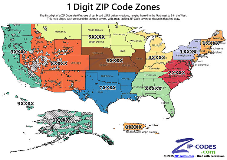
The first digit of a ZIP Code represents a group of states. It acts as the first step in organizing routes for efficient mail delivery. The first digit of a ZIP Code divides the country into ten broad postal regions (0–9). These regions move roughly from the Northeast (0XXXX) to the West Coast (9XXXX). Each "zone" covers several states and knowing the first digit of a ZIP Code generally tells you which part of the country it is in.
Quick reference of 1st Digit ZIP Code and states it covers:
| 1st Digit | States |
|---|---|
| 0 | Connecticut, Massachusetts, Maine, New Hampshire, New Jersey, Puerto Rico, Rhode Island, Vermont, Virgin Islands |
| 1 | Delaware, New York, Pennsylvania |
| 2 | District of Columbia, Maryland, North Carolina, South Carolina, Virginia, West Virginia |
| 3 | Alabama, Florida, Georgia, Mississippi, Tennessee |
| 4 | Indiana, Kentucky, Michigan, Ohio |
| 5 | Iowa, Minnesota, Montana, North Dakota, South Dakota, Wisconsin |
| 6 | Illinois, Kansas, Missouri, Nebraska |
| 7 | Arkansas, Louisiana, Oklahoma, Texas |
| 8 | Arizona, Colorado, Idaho, New Mexico, Nevada, Utah, Wyoming |
| 9 | Alaska, American Samoa, California, Guam, Hawaii, Marshall Islands, Federated States of Micronesia, Northern Mariana Islands, Oregon, Palau, Washington |