All 94+ data fields documented with descriptions, data types, examples, and edition availability.
Field Name | Description & Example | Data Type | Standard | Deluxe | Business |
---|---|---|---|---|---|
ZIP |
5-digit ZIP Code Example: 12533
|
VARCHAR(5) | |||
City |
USPS preferred city name (uppercase) Example: HOPEWELL JUNCTION
|
VARCHAR(35) | |||
State |
2-character state abbreviation Example: NY
|
CHAR(2) | |||
StateFullName |
Full state name Example: New York
|
VARCHAR(50) | |||
County |
Primary county name (proper case) Example: Dutchess Multi-county ZIPs use supplemental file in Business edition |
VARCHAR(25) | |||
AreaCode |
Area code(s) separated by forward slash Example: 845/914
|
VARCHAR(20) | |||
Latitude |
ZIP Code centroid latitude (WGS84 datum) Example: 41.583325
|
DECIMAL(10,6) | |||
Longitude |
ZIP Code centroid longitude (WGS84 datum) Example: -73.780928
|
DECIMAL(10,6) |
Field Name | Description & Example | Data Type | Standard | Deluxe | Business |
---|---|---|---|---|---|
Population |
Total population from Census 2020 Example: 28945
|
INT | |||
CurrentPopulation |
Estimated current population Example: 29450 Proprietary estimate based on active delivery points. For official counts, use Population field (Census 2020). |
INT | |||
Households |
Number of households Example: 11234
|
INT | |||
PersonsPerHousehold |
Average persons per household Example: 2.58
|
DECIMAL(3,2) | |||
MedianIncome |
Median household income (annual) Example: 72500 From American Community Survey (ACS) |
INT | |||
MedianHouseValue |
Median home value Example: 325000
|
INT | |||
MedianAge |
Median age of population Example: 42.5
|
DECIMAL(4,1) | |||
MedianAgeMale |
Median age of male population Example: 41.3
|
DECIMAL(4,1) | |||
MedianAgeFemale |
Median age of female population Example: 43.7
|
DECIMAL(4,1) | |||
WhitePopulation |
White alone population count Example: 22450
|
INT | |||
BlackPopulation |
Black or African American alone population count Example: 3200
|
INT | |||
HispanicPopulation |
Hispanic or Latino population count Example: 2100
|
INT | |||
AsianPopulation |
Asian alone population count Example: 1850
|
INT | |||
NativeHawaiianPopulation |
Native Hawaiian and Other Pacific Islander alone population count Example: 25
|
INT | |||
AmericanIndianPopulation |
American Indian and Alaska Native alone population count Example: 120
|
INT | |||
OtherRacePopulation |
Some other race alone population count Example: 850
|
INT | |||
MalePopulation |
Male population count Example: 14120
|
INT | |||
FemalePopulation |
Female population count Example: 14825
|
INT |
Field Name | Description & Example | Data Type | Standard | Deluxe | Business |
---|---|---|---|---|---|
MSACode |
Metropolitan Statistical Area code (legacy) Example: 5602
|
VARCHAR(4) | |||
MSAName |
Metropolitan Statistical Area name (legacy) Example: New York-Northern New Jersey-Long Island, NY-NJ-CT-PA
|
VARCHAR(100) | |||
PMSACode |
Primary Metropolitan Statistical Area code (legacy) Example: 5380
|
VARCHAR(4) | |||
PMSAName |
Primary Metropolitan Statistical Area name (legacy) Example: Nassau-Suffolk, NY PMSA
|
VARCHAR(100) | |||
CSACode |
Combined Statistical Area code (legacy) Example: 408
|
VARCHAR(3) | |||
CSAName |
Combined Statistical Area name (legacy) Example: New York-Newark, NY-NJ-CT-PA
|
VARCHAR(100) | |||
CBSACode |
Core Based Statistical Area code (current standard) Example: 35620
|
VARCHAR(5) | |||
CBSAType |
CBSA classification type Example: Metro or Micro
|
VARCHAR(10) | |||
CBSAName |
Core Based Statistical Area name Example: New York-Newark-Jersey City, NY-NJ
|
VARCHAR(100) | |||
CBSADivisionCode |
Metropolitan Division code (subdivisions of large CBSAs) Example: 35004
|
VARCHAR(5) | |||
CBSADivisionName |
Metropolitan Division name Example: Nassau County-Suffolk County, NY
|
VARCHAR(100) | |||
CBSAPopulation |
Total population of the CBSA Example: 18897109
|
INT | |||
CBSADivisionPopulation |
Total population of the Metropolitan Division Example: 2832882
|
INT | |||
Region |
U.S. Census Bureau region Example: Northeast Four regions: Northeast, Midwest, South, West |
VARCHAR(20) | |||
Division |
U.S. Census Bureau division Example: Middle Atlantic Nine divisions subdivide the four regions |
VARCHAR(25) | |||
CongressionalDistrict |
Congressional district number (Latest Congress) Example: 18
|
VARCHAR(2) | |||
CongressionalLandArea |
Land area of congressional district in square miles Example: 182.01
|
DECIMAL(10,2) |
USPS operational data including delivery infrastructure, facility information, and ZIP Code lifecycle dates.
Field Name | Description & Example | Data Type | Standard | Deluxe | Business |
---|---|---|---|---|---|
ResidentialMailboxes |
Number of residential delivery points Example: 8946
|
INT | |||
BusinessMailboxes |
Number of business delivery points Example: 686
|
INT | |||
TotalActiveDeliveries |
Total active delivery points (residential + business) Example: 11452
|
INT | |||
BoxCount |
Number of PO boxes Example: 1303
|
INT | |||
SingleFamilyDeliveryUnits |
Single family delivery unit count Example: 5662
|
INT | |||
MultiFamilyDeliveryUnits |
Multi-family delivery unit count Example: 814
|
INT | |||
ZIPIntroDate |
Date ZIP Code was introduced Example: <2004-10 Format: YYYY-MM or <YYYY-MM for dates before our records began |
VARCHAR(10) | |||
AliasIntroDate |
Date city alias was introduced Example: 2012-08 When USPS added alternate city names for this ZIP |
VARCHAR(10) | |||
FacilityCode |
USPS facility type code Example: P (Post Office), B (Branch), S (Station), U (Unique)
|
CHAR(1) | |||
CityDeliveryIndicator |
City delivery service indicator Example: Y (Yes) or N (No)
|
CHAR(1) | |||
CarrierRouteSortation |
Carrier route sortation facility indicator Example: C (City), R (Rural), H (Highway Contract)
|
CHAR(1) | |||
FinanceNumber |
USPS finance number Example: 353910
|
VARCHAR(6) | |||
UniqueZIPName |
Unique ZIP indicator (Y/N blank) Example: Y Indicates if this is the only ZIP for this city name |
CHAR(1) |
Physical location characteristics including elevation, time zones, and geographic area measurements.
Field Name | Description & Example | Data Type | Standard | Deluxe | Business |
---|---|---|---|---|---|
Elevation |
Elevation above sea level in feet Example: 364
|
INT | |||
Timezone |
Time zone offset from UTC Example: 5 (Eastern = UTC-5), 6 (Central = UTC-6)Standard time offset, not accounting for DST |
INT | |||
DaylightSaving |
Daylight Saving Time observance Example: Y (Yes) or N (No) |
CHAR(1) | |||
LandArea |
Land area in square miles Example: 64.416
|
DECIMAL(10,3) | |||
WaterArea |
Water area in square miles Example: 0.308
|
DECIMAL(10,3) |
Federal government coding systems (FIPS, ANSI, SSA) used for data matching and integration with government datasets.
Field Name | Description & Example | Data Type | Standard | Deluxe | Business |
---|---|---|---|---|---|
CountyFIPS |
3-digit county FIPS code Example: 027 Federal Information Processing Standard code for counties |
CHAR(3) | |||
StateFIPS |
2-digit state FIPS code Example: 36
|
CHAR(2) | |||
StateFIPSCode |
5-digit combined state+county FIPS code Example: 36027 Concatenation of StateFIPS + CountyFIPS for easier querying |
VARCHAR(5) | |||
CountyANSI |
County ANSI code Example: 00809654 American National Standards Institute geographic code |
VARCHAR(8) | |||
StateANSI |
State ANSI code Example: 01779809
|
VARCHAR(8) | |||
PlaceFIPS |
Census place FIPS code Example: 34045 Identifies incorporated places and Census-designated places |
VARCHAR(5) | |||
SSACountyCode |
Social Security Administration state-county code Example: 33700 Used by SSA for benefit administration |
VARCHAR(5) |
Economic activity metrics from the U.S. Census Bureau's County Business Patterns program.
Field Name | Description & Example | Data Type | Standard | Deluxe | Business |
---|---|---|---|---|---|
NumberOfBusinesses |
Total number of business establishments Example: 1247 From Census Bureau County Business Patterns |
INT | |||
NumberOfEmployees |
Total number of employees Example: 18450
|
INT | |||
Q1Payroll |
First quarter payroll (in thousands) Example: 145250 ($145,250,000)
|
INT | |||
AnnualPayroll |
Annual payroll (in thousands) Example: 598750 ($598,750,000)
|
INT | |||
EmploymentFlag |
Data suppression flag (blank or space) Example: (blank = data available)Census suppresses data for privacy when establishment counts are very low |
CHAR(1) |
Medicare geographic classifications and health insurance rating areas used by CMS and healthcare organizations.
Field Name | Description & Example | Data Type | Standard | Deluxe | Business |
---|---|---|---|---|---|
MedicareCBSACode |
Medicare-specific CBSA code Example: 35004 Used by CMS (Centers for Medicare & Medicaid Services) for reimbursement rates |
VARCHAR(5) | |||
MedicareCBSAName |
Medicare CBSA name Example: Nassau County-Suffolk County, NY
|
VARCHAR(100) | |||
MedicareCBSAType |
Medicare CBSA classification Example: Metro or Micro Affects Medicare payment adjustments |
VARCHAR(10) | |||
MarketRatingAreaID |
Health insurance rating area identifier Example: 8 Used by insurance companies for ACA marketplace premium calculations |
VARCHAR(5) |
Choose the edition that fits your needs
Detailed technical specifications for seamless integration with your systems.
Delimiter: | , (comma) |
Text Qualifier: | " (double quote) - used when fields contain commas |
Character Encoding: | UTF-8 (Unicode) |
Line Endings: | CRLF (Windows-style: \r\n ) |
Header Row: | Yes - First row contains field names |
Supplemental: | Business has Files: census-2010-zcta.csv, census-2020-zcta.csv, census-acs-{YYYY}-{YYYY}-zcta.csv, zip-codes-database-DELUXE-BUSINESS.csv, and zip-codes-database-MULTI-COUNTY.csv |
BOM: | No byte order mark (UTF-8 without BOM) |
Null Values: | Empty string (no quotes between delimiters) |
Versions Available: | MySQL 5.7+ and SQL Server 2008+ |
Script Structure: |
1. DROP TABLE (if exists)2. CREATE TABLE with schema3. INSERT INTO statements
|
Table Name: | ZIPCodes (Actual case) |
Primary Key: | None - Can define in CREATE statement, duplicates exist |
Supplemental: | Business has Tables: PlaceFIPS, MultiCounty, Census_ACS |
Character Set: | UTF-8 (utf8mb4 for MySQL) |
Batch Size: | MySQL: 1000 rows/INSERT | SQL Server: 1000 rows/INSERT |
NULL Handling: | NULL keyword (not quoted) |
-- MySQL Example
CREATE TABLE zipcodes (
ZIP VARCHAR(5) PRIMARY KEY,
City VARCHAR(35),
State CHAR(2),
County VARCHAR(25),
Latitude DECIMAL(10,6),
Longitude DECIMAL(10,6),
-- ... additional fields
) ENGINE=InnoDB DEFAULT CHARSET=utf8mb4;
Format: | .mdb (Access 2007+) |
Compatibility: | Access 2007, 2010, 2013, 2016, 2019, 365 |
Table Name: | ZipCodeDatabase_{Edition} |
Primary Key: | None - ZIPCode is Indexed (has Duplicates) |
Relationships: | None - Single table database |
Supplemental: | Business has Tables: ZipCodeDatabase_MULTI_COUNTY and ZipCodeDatabase_PLACE_FIPS |
Indexes: |
No Primary Key Indexes on ZIPCode, State, County |
Compression: | Yes - Database is compacted |
Format: | .xls (Excel 2007+) |
Compatibility: | Excel 2007, 2010, 2013, 2016, 2019, 365 |
Sheet Structure: | 2 worksheets: zip-codes-database- and zip-codes-database2- |
Header Row: | Row 1 - Column headers in text form |
Data Starts: | Row 2 |
Total Rows: | ~26,000 data rows each (meets old Excel row limit). Recommend CSV version. |
Column Widths: | You can Auto-size for readability |
MedianIncome
, CBSACode
)00501
)Evaluate the data quality and format before purchasing. All samples contain real data from our database.
25 sample records showing core geographic fields including ZIP, city, state, county, coordinates, and more.
25 sample records with demographics, income, statistical areas, and everything in Standard.
25 sample records with complete business data, employment stats, Medicare codes, and all 94+ fields.
Test integration with your systems, verify data quality, and ensure the format meets your needs - all before purchasing. These are real records from our production database, not mock data.
Still working on this section. Stay tuned!
Real technical questions from real developers in the trenches. We've been doing this since 2003, so we've seen every edge case imaginable. This FAQ covers everything from character encoding to multi-county ZIPs to why the USPS does things that make you scratch your head. Whether you're integrating at 2 PM or 2 AM, this FAQ will save you time and headaches.
We use empty strings (""
) rather than NULL
values.
Why? Years ago, we worked with small businesses and individuals who understood "empty" but struggled with the null concept. Looking back, we probably should have stuck with NULL
, but here we are. The good news: it's consistent across all fields.
Key points:
0
rather than left empty.if (field === '' || field === null)
.Developer tip: Military ZIPs (APO/FPO/DPO), PO Box ZIPs, and Unique ZIPs often have empty values for geographic fields like County, Coordinates, and Time Zone since they don't represent traditional delivery areas.
All files use UTF-8 encoding to support international characters and special symbols.
Platform-specific recommendations:
utf8mb4
character set and collation.ENCODING 'UTF8'
when creating database.NVARCHAR
data types for Unicode support.Using UTF-8 ensures proper handling of place names with diacritics (e.g., San José, Montréal) and special characters in city alias names.
See our File Format Specifications section for detailed encoding information by format.
Approximately 23% of ZIP Codes cross county boundaries. The main database shows the primary county - the one that receives the largest volume of mail.
Business Edition includes a Multi-County supplemental file with over 22,000 records detailing all county associations for ZIPs that cross boundaries.
Supplemental file structure:
ZipCode | StateFIPS | State | CountyFIPS | County
Implementation strategies:
Coordinate system: WGS84 (World Geodetic System 1984) datum
Precision: 6 decimal places (DECIMAL(10,6)
)
What the coordinates represent:
0, 0
since they represent overseas locations.Coordinate accuracy:
We only assign coordinates when we can determine them with reasonable certainty. If coordinates cannot be reliably determined, we set them to 0, 0
rather than guess. This maintains data integrity - a core principle at ZIP-Codes.com.
For GIS applications: WGS84 is compatible with Google Maps, Leaflet, Mapbox, and most modern mapping libraries. For spatial database queries, create a spatial index on the Latitude/Longitude columns for optimal performance.
Essential indexes:
ZIP
field + Primary (always index both when you want distinct values only).State
, County
, City
.CBSACode
, MSACode
if querying statistical areas.Sample index creation (MySQL):
CREATE INDEX idx_zipcode ON zipcodes(ZipCode);
CREATE INDEX idx_state ON zipcodes(State);
CREATE INDEX idx_county ON zipcodes(County);
CREATE INDEX idx_city ON zipcodes(City);
-- For composite queries (ZipCode + Primary Record)
CREATE INDEX idx_zip_primary ON zipcodes(ZipCode, Primary);
-- For composite queries (State + City lookups)
CREATE INDEX idx_state_city ON zipcodes(State, City);
-- For geospatial (if your DB supports it)
CREATE SPATIAL INDEX idx_coords ON zipcodes(Latitude, Longitude);
Index strategy tips:
(State, City)
helps State-only queries, but not City-only.See our Integration Guides section for complete indexing examples by database platform.
With proper indexing, ZIP Code lookups are fast.
Performance benchmarks:
Real-world example:
Our production SQL Server handles all website traffic with query times averaging under 100ms - without special performance tuning. A properly indexed table with adequate hardware can achieve significantly faster lookups.
Performance tips:
The database size itself is modest (17-55MB depending on edition), so performance bottlenecks typically come from network latency or unindexed queries, not the data volume.
Short answer: It's no longer valid.
We get this question often, and it's always investigated. The ZIP Code used to be valid but is no longer in service. The USPS revises ZIP Codes regularly to match current delivery needs. ZIP-Codes.com is a licensed USPS distributor and only publishes currently active ZIP Codes.
Common scenarios:
Verify it yourself:
Use the official USPS ZIP Code Lookup tool at https://tools.usps.com/zip-code-lookup.htm. If the USPS reports it as invalid and you believe this is an error, contact us and we'll research it immediately.
Data quality matters:
Other websites and free datasets don't adhere to the same data quality standards we do. Many use Census ZCTA data or simply never remove discontinued ZIPs. We update monthly with verified USPS data to ensure you're always working with accurate, current information.
We use real USPS ZIP Codes, not Census approximations.
ZIP Code Tabulation Areas (ZCTAs) are generalized area representations created by the U.S. Census Bureau. They only update every 10 years with each decennial census, which means they diverge from actual ZIP Code boundaries over time.
Many providers use Census ZCTA data and market it as "ZIP Codes." ZIP-Codes.com licenses true ZIP Code data directly from the USPS and updates it monthly as changes occur. When your business depends on accurate data, "close enough" isn't good enough.
Why this matters:
The exception:
Some demographic fields (like Census population data) are only available at the ZCTA level - we clearly label these fields. To counter this limitation, we provide our own CurrentPopulation
estimate calculated from active delivery points.
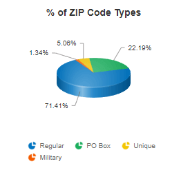
There are currently 41,558 active ZIP Codes in the United States and territories, as of October, 2025.
ZIP Code types (by Classification Code):
It should be noted that on occassion, a ZIP Code classified as a PO Box can also have limited street delivery as well. When this happens, you usually see some added population and demographic data.
All versions include all ZIP Code types. Each record contains a ClassificationCode
field so you can filter by type or check if a ZIP has special limitations (many companies can't ship to Military ZIPs, for example).
Additional statistics:
Numbers can fluctuate monthly as the USPS creates new ZIPs and discontinues old ones. View detailed ZIP Code statistics →
Because people can identify with multiple races on the Census.
Since the 2000 Census, Americans have been able to select more than one racial category. The 2010 Census alone had 63 possible race categories (6 individual races and 57 combinations). Over 9 million Americans (2.9% of the population) chose multiple races in 2010, but in 2020, 10.2% of the population chose multiple races.
How this affects the math:
WhitePopulation
AND once in BlackPopulation
.Hispanic or Latino: Hispanic or Latino is an ethnicity, not a race. This means individuals who identify as Hispanic will also be included in one of the race categories (such as White or Black). As a result, the totals shown here may exceed 100% when Hispanic is displayed alongside racial groups. Customers have explicitly asked for Hispanic Population numbers, so they are presented alongside the racial categories. However, the fact it has it's own distinct definition is usually lost. It is a critical distinction.
This applies at all geographic levels: ZIP Code, City, County, and State data all exhibit this behavior. It's not an error - it's how the Census Bureau reports race data.
Learn more about Census race and ethnicity methodology at the Census Bureau website.
Because not everyone lives in a ZIP Code.
ZIP Codes exist for mail delivery, not population enumeration. Several factors cause discrepancies between ZIP-level population sums and higher-level Census totals:
People not in ZIP Codes:
Special populations:
Census methodology:
Bottom line: ZIP-level population sums will not match state/national totals exactly. Use ZIP Code demographics for local analysis and targeting, not for verifying Census Bureau totals.
FTP access is included with your subscription at no extra cost.
Setup process:
Connection details:
Update schedule:
Folder structure:
Each product has its own folder. You'll have access only to folders for your active subscriptions:
ZIP-STANDARD
, ZIP-DELUXE
, ZIP-BUSINESS
- ZIP Code databasesZIP-4-DELUXE
, ZIP-4-STANDARD
- ZIP+4 databasesCAN-BUSINESS
, CAN-DELUXE
, CAN-STANDARD
- Canadian postal codesNPANXX-DELUXE
, NPANXX-STANDARD
- Area code databasesFor detailed FTP setup instructions and firewall configuration, visit our FTP Services Guide.
We recommend full replace for most applications.
Full Replace Method (Recommended):
Why full replace works best:
Incremental Update Method:
See our Integration Guides section for sample update scripts by database platform.
Updated monthly on the 1st. Our current data was last updated October 1, 2025.
Update frequency:
Why monthly updates matter:
The USPS typically introduces 10-50 changes per month. We admit, that isn't tremendous churn, and ZIP Codes are relatively stable. However, we have multiple data sources, and those follow various update schedules - we consolidate, validate, and publish promptly. It's not only ZIP Codes you rely on, it's everything related to it. In today's business landscape, data timeliness ensures:
Need real-time data? Consider our ZIP Code API for up-to-the-minute validation and lookups.
Yes, we maintain monthly versions dating back to October 2004.
Available options:
Formats available:
Use cases for historical data:
Note: Historical data reflects what was current at that point in time. Coordinates, demographics, and other fields may have been updated in subsequent months.
No. ZIP Codes are mail delivery routes, not geographic divisions.
Most people think of ZIP Codes as: Nation > State > County > City > ZIP Code. This is incorrect.
What ZIP Codes actually are:
Real-world example:
Imagine a postal carrier placing mail in mailboxes down a long street. It would be highly inconvenient to stop and turn around at an imaginary county boundary line. The carrier continues the route to finish delivery- which means the ZIP Code crosses the county line.
Why this matters for developers:
For true geographic analysis, use Census Blocks, Tracts, or Counties - not ZIP Codes.
No. ZIP Codes have city names for reference, but they are not cities.
The disconnect:
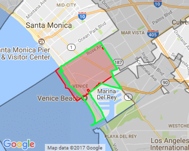
Real example: Venice, California
ZIP Code 90291 is for Venice, CA. Venice is a neighborhood within Los Angeles city limits with a population over 28,000. However:
City Aliases:
Our database includes a CityAlias
field listing alternate acceptable city names for mailing. Towns, villages, and well-known neighborhoods often appear here.
For developers:
City
field for USPS-preferred mailing namesCityAlias
for alternate acceptable namesEach ZIP Code is assigned one time zone based on where the majority of addresses are located.
Time zone format:
We use a numeric UTC offset system (legacy format we've maintained for compatibility):
4
= Atlantic (GMT -04:00)5
= Eastern (GMT -05:00)6
= Central (GMT -06:00)7
= Mountain (GMT -07:00)8
= Pacific (GMT -08:00)9
= Alaska (GMT -09:00)10
= Hawaii-Aleutian Islands (GMT -10:00)11
= American Samoa (GMT -11:00)13
= Marshall Islands (GMT +12:00)14
= Guam (GMT +10:00)15
= Palau (GMT +9:00)16
= Micronesia (GMT +11:00)Daylight Saving Time:
The DaylightSaving
field indicates whether the ZIP observes DST:
Y
= Observes DST (most of the US)N
= Does not observe DST (Arizona*, Hawaii, and most territories)*Exception: The Navajo Nation in Arizona does observe DST
Edge cases:
Note: We don't use IANA time zone identifiers (e.g., "America/New_York"). If you need IANA format, you'll need to map our numeric codes to IANA zones in your application.
We treat county equivalents exactly like counties-no special handling required.
Some states use different terminology for their county-level divisions, but the data structure remains consistent across all states:
States with county equivalents:
How we handle them:
All county equivalents receive a standard County FIPS code from the federal government and are included in our County
and CountyFIPS
fields just like traditional counties. You don't need to do anything special in your code - query by county name or FIPS code as normal.
Examples:
County: Anchorage
with FIPS code 02020
County: Orleans
with FIPS code 22071
County: Capitol
with FIPS code 09110
County: Fairfax City
with FIPS code 51600
Connecticut's unique situation:
Connecticut eliminated county-level government in 1960 but retained counties for statistical purposes. In 2022, they officially replaced counties with Planning Regions. The U.S. Census began releasing data at the new region level in 2023. The USPS updated its ZIP Code products to use planning regions in July 2024.
This staggered rollout created significant challenges, especially for individuals unaware of the change. It was publicized, but not widely known. Our ZIP Code Database includes the new Planning Region FIPS codes and names from the USPS. However, if you're working with Connecticut data, you'll need to maintain a historical county crosswalk for relating to older datasets that still reference the legacy county structure. The Planning Regions received entirely new FIPS codes as part of the transition.
We've created a comprehensive guide with ZIP Code to Historical County crosswalks (including ZIP+4 level) to help smooth this transition. Evena cool map to see the relation of between ZIP Codes, Towns, Historical Counties, and new Planning Regions.
Read our complete guide to Connecticut's planning regions →
Bottom line: Whether it's a county, parish, borough, or planning region-we use the current federal standard. Just be aware that Connecticut requires special attention if you're integrating with historical data sources.
Yes, we offer a separate ZIP Code API service.
ZIP Code API features:
Pricing:
The API is a separate purchase with monthly billing based on request volume:
Database vs API - which to choose?
Note: The API is designed for lookups and validation, not bulk data transfer. If you need all records, the database download is more efficient and cost-effective.
Yes, all military ZIP Codes are included in every edition.
Military ZIP Code types:
What to expect:
Military ZIPs have basic information but lack geographic data since they represent overseas locations:
For developers:
ClassificationCode = 'M'
to identify military ZIPs.Military ZIP Codes follow different rules than civilian ZIPs - they're included for completeness, but they do have limited data fields due to their unique usage. The USPS maintains these so U.S. families can send mail and packages to a local "address". They collect the mail and deliver to military transit locations who then get it to our service men and woman; whether they are on a boat, in a plane, at an overseas base, or hidden in an undisclosed bunker somewhere. P.S. We are a veteran owned business!
We provide free technical support to all customers.
Email: info@zip-codes.com | Phone: 1-800-425-1169