Who is writing this. Zip-Codes.com sells U.S. ZIP Code boundary files built from USPS carrier routes, and has since 2014, years before USPS offered polygons of its own. USPS ZIP Code Boundaries now competes with what we sell. Census ZCTAs are a free Census Bureau product, not ours and not USPS’s. We have tried to describe all three fairly, quote the primary sources, and say where each one is the better choice. If something here is wrong, tell us and we will fix it.
The short answer
- Census ZCTAs are free, but they are a 2020 snapshot built from census blocks, not mail routes. 7,733 of the 41,514 ZIP Codes in use today (18.6%) have no ZCTA. Most of those are PO Box, building and military ZIP Codes, but the gap also includes every ZIP Code created since 2020. Use ZCTAs to join Census data.
- USPS ZIP Code Boundaries are the Postal Service’s own polygons, built from its delivery points and updated quarterly. They cost $10,000, $33,000 or $150,000 a year and list six fields including the shape. The $10,000 Internal license forbids derivative works and publication of findings.
- Our ZIP Code boundaries are built from USPS carrier routes and rebuilt quarterly. They include PO Box and building ZIP Codes as points and delivery counts on every record. One user pays $5 a ZIP Code, $645 a state or $1,290 nationwide; company-wide licenses start at $5,160 a year.
Does USPS publish official ZIP Code boundaries now?
Yes. The Postal Service now sells USPS ZIP Code Boundaries, a national layer of 5-digit ZIP Code polygons, through its PostalPro site. Its documents are dated 2026: the license is version April 21, 2026, and the order form (ZCB001) is September 2026. USPS describes it as “a national ZIP Code map utilizing USPS delivery route, address, and location information,” and its briefing sheet describes the operation behind it: 235,000 delivery routes and about 5 billion one-second GPS breadcrumbs a day from carriers’ devices. (Those figures describe USPS’s operations; the technical guide’s listed inputs are delivery points, a city/state table, state boundaries and a coastline.)
Its public documents describe these inputs, outputs and terms:
- How the polygons are made. The technical guide says the areas are computer-generated from USPS delivery points. It uses only door delivery points, excludes “all CRIDs beginning with ‘B’ (business location)” (in USPS carrier route codes a B prefix normally marks a PO Box section), and keeps only ZIP Codes with a blank ZIP class code. In USPS’s City State file, P, U and M mark PO Box, Unique (single-organization) and Military ZIP Codes, so the filter suggests those are left out. That is our reading of the documentation, and it is not yet reconciled with the briefing sheet’s “~40,000 polygons”; we have not inspected the delivered file. Separately, the license’s Exhibit A says the delivery-location version “is based on Census Blocks where population data exists.”
- Two versions. A contiguous layer that covers land and water, and a clipped layer with large water bodies, large parks and areas with no deliveries removed.
- Six fields. The documented output schema lists ZIP Code, an object ID, the shape, state, city names (comma separated) and county name. It does not list centroids, delivery counts, ZIP Code type or FIPS codes.
- Formats. File geodatabase or GeoJSON, sold as separate products at the same price. The briefing sheet and license also mention shapefile, and the technical guide says “computed files are in ESRI shapefile format (EPSG: 6933).”
- Ordering. An order form with payment by card (faxed), ACH, check or USPS money order, a separate form for access to USPS’s download portal (EPF), and a signed license. No refunds once the file is downloaded.
Are ZIP Codes really polygons?
No. A ZIP Code is a set of delivery addresses grouped for sorting and carrier routes, not an area with a legal boundary. A building, a single company or a bank of PO boxes can have a ZIP Code of its own, and a new subdivision joins whichever ZIP Code’s carrier extends a route to it. Every ZIP Code map is a considered representation of that network. The useful questions are what it was built from, what it leaves out, how often it is rebuilt, and what you may do with it.
How do the three files compare?
Each row is something you would check before choosing a file. Hatching marks where a file does not offer it at all.
| Census ZCTAfree | USPS ZIP Code Boundariesfrom $10,000/yr | Our ZIP Code boundariesfrom $5 | |
|---|---|---|---|
| How the shapes are made | |||
| Built fromZCTA assigns each 2020 census block to “the ZIP Code associated with the most addresses in that block.” USPS uses door delivery points of standard ZIP Codes. Ours combines USPS carrier route boundaries and snaps edges to street centerlines where a road forms the boundary. | Censusblocks | Deliverypoints | Carrierroutes |
| How often it is rebuiltZIP Codes change as USPS reorganizes delivery. A boundary set is only as current as its last rebuild. | Decennial2020 is current | Quarterly4× a year | Quarterly4× a year |
| ZIP Codes created since 202078 so far, some with over 12,000 homes | ✓ | ✓ | |
| Covers the country with no gapsZCTAs may leave uninhabited land and water over two square miles unassigned. USPS’s contiguous layer and our filler polygons cover it. | ✓ | ✓ | |
| What is in the file | |||
| PO Box and building ZIP CodesMost have no ZCTA: 5,181 of 9,119 PO Box and 1,681 of 2,015 Unique ZIP Codes are missing. USPS’s input keeps blank class codes only, which suggests they are left out. Ours carries them as points, or as polygons where they have a delivery area. | Somemost missing | Unclearsee note | ✓ |
| Which ZIP Code a PO Box sits insideOur ENCZIP field names the polygon that contains each point ZIP Code | ✓ | ||
| Delivery countsResidential, apartment, house, business and PO Box deliveries on every record | ✓ | ||
| Fields per recordUSPS documents ZIP, ID, shape, state, city names and county. Ours adds ZIP Code type, state and county FIPS, an interior point, delivery counts and a map color index. | Codeand area | 6incl. shape | 19fields |
| FormatsOurs: shapefile, GeoJSON, KML, WKT, CSV, SQL Server, PostgreSQL/PostGIS and MySQL in one download | 3SHP, GDB, KML | 2GDB or GeoJSON | 8formats |
| Buying and using it | |||
| Buy a single state or a few ZIP CodesUSPS sells the national file only | Freedownload | ✓ | |
| Use what you learn in work for customersUSPS Internal forbids “publication of findings of any kind”; Publication ($150,000) allows limited images. Ours lets conclusions and recommendations form part of your services to customers (section 5(c)); the boundaries, and maps or reports made from them, stay in-house. | ✓ | $150,000tier only | Conclusionsnot maps or data |
| Buy online and download nowUSPS: order form, payment by fax or mail, portal access form and a signed license | ✓ | ✓ | |
Reading the colors: the stronger option baseline Hatched = not offered.
Census counts are from the 2020 ZCTA file. Ours are from our August 2026 release. USPS figures are from its briefing sheet, technical guide (version 3, April 2026), license and order form; see Sources.
See the difference for yourself. Put our boundaries next to the ZCTA file on the live map below, or download a sample for your own GIS.
Compare on the live map Download a free sampleWhat does each one cost, and what may you do with it?
USPS’s entry license is $10,000 a year for internal use across an organization. Here it is next to ours.
| USPS Internalorganization-wide | Ours, company-wideup to 5,000 employees | Ours, one userone named person | |
|---|---|---|---|
| Price per year | |||
| Nationwide | $10,000national only | $5,160–$7,740by company size | $1,290nationwide |
| One state | $2,580–$3,870by company size | $645any state | |
| A few ZIP Codesup to 65 | $5each | ||
| Quarterly updates included | ✓ | ✓ | ✓ |
| What you may do | |||
| Everyone in the organization may use it | ✓ | ✓ | |
| Use conclusions from the data in work for customersUSPS Internal: “no derivative works or publication of findings of any kind.” Ours, section 5(c): conclusions or recommendations may “form part of Licensee’s services to its customers.” | ✓ | ✓ | |
| Give customers maps or reports made from the dataOurs, section 5(c): the licensee “may not provide Data Output as part of those services.” Data Output means the maps, reports and other information generated from the data. | |||
| Open to shipping and logistics companiesUSPS section 9: “no Competitors of USPS may obtain any rights in the Data or Database” | ✓ | ✓ | |
| Share or resell the boundary files themselves | |||
| Buying it | |||
| RefundUSPS: no refunds once the order is processed and the file downloaded | 30 daysfull refund | 30 daysfull refund | |
| $10,000 /year USPS PostalPro | from $5,160 /year Price your license Download free sample | from $5 /ZIP Code Price your area Try the demo | |
USPS also sells Enterprise ($33,000 a year: sharing with approved subsidiaries and parent companies) and Publication ($150,000 a year: limited publication of images, with attribution, disclosure to USPS and a right to audit). Our licenses also come for 2 to 25 named users; companies over 5,000 employees, call us. Every price here is per year and includes all eight formats and four quarterly releases. See the price calculator.
The USPS license, in its own words
Within the permitted use, section 1 lets the licensee “use, copy, modify and distribute” the data, and Exhibit D lets Enterprise customers share what it calls derivative works with approved affiliates. These are the restrictive clauses that matter most in practice:
“No derivative works of the Database or Data are allowed.”USPS ZIP Code Boundaries Data License, section 1
The licensee “shall not disclose, release, distribute, or deliver the Database or Data, any portion of the Data or Database, or any other information derived from the Data or Database to any third party without LICENSOR’s prior written consent.”Section 3
“Licensee agrees Licensor owns and will own all right, title, and interest, including all copyrights, in any and all derivative compilations created by Licensee.”Section 6
Licensees may not market the data to “entities in the mailing and shipping business, including, but not limited to, FedEx, UPS, Amazon, and DHL,” and “no Competitors of USPS may obtain any rights in the Data or Database.”Section 9
Licensees also may not publicize that they use the data without USPS’s written consent (section 5), and USPS may audit their records up to twice a year (section 16(h)). If you plan to put ZIP Code shapes on a public website, in a product you sell, or in the hands of a carrier or logistics company, read the whole license before you order.
Our license
Our boundary data license is also an internal-use license: section 4(a) allows the data, and the maps and reports you make from it, “only for its own internal business purposes,” and section 5 bars derivative works. The difference is that you may use what you learn:
“Licensee may use Data Output to derive conclusions or recommendations that form part of Licensee’s services to its customers, but Licensee may not provide Data Output as part of those services.”Zip-Codes.com boundary data license, section 5(c). “Data Output” is defined in section 1 as “the maps, reports or other information generated by analyzing or processing” the data.
So you may tell a client which ZIP Codes to target, how many households a territory holds or where to open a store. You may not hand over the boundaries, or the maps and reports you made from them, and the files may not be shared or resold. Running a service for others on the data, such as adding ZIP Codes or coordinates to their records, needs an order that allows it (section 4(a)). (A polygon lookup gives the mapped ZIP Code area, not the mailing ZIP Code of an address; for that, validate the address.)
Census ZCTAs are free to download from the Census Bureau’s TIGER/Line and cartographic boundary files as public U.S. government data. The 2020 delineation is the current one; even files labeled 2024 or 2025 carry the 2020 ZCTA shapes.
What do free ZCTAs leave out?
The Census Bureau is clear that “not all valid ZIP Codes are represented by a 2020 ZCTA.” We compared our current ZIP Code list with the 2020 ZCTA file:
| ZIP Code type | In use today | Have a 2020 ZCTA | No ZCTA |
|---|---|---|---|
| Standard | 29,808 | 29,509 | 299 (1.0%) |
| PO Box | 9,119 | 3,938 | 5,181 (56.8%) |
| Unique (one organization) | 2,015 | 334 | 1,681 (83.4%) |
| Military | 572 | 0 | 572 (100%) |
| All | 41,514 | 33,781 | 7,733 (18.6%) |
Among Standard ZIP Codes the gap is small: 299 of 29,808 (1.0%). It includes the 78 ZIP Codes created since the 2020 file was drawn, and some are large: 85288 in Tempe, Arizona (created 2021, about 12,900 residential addresses), 85144 in San Tan Valley, Arizona (2023, about 11,100) and 84048 in Lehi, Utah (2025, about 12,400) have no ZCTA at all. Ten ZCTAs belong to ZIP Codes that are no longer in use.
Where both exist, how closely do they match?
For the 32,709 ZIP Codes that have both one of our polygons and a ZCTA, we measured how much the two shapes overlap (the shared area divided by the combined area, so 1.0 is identical). These numbers measure agreement between two boundary models, not accuracy against delivery addresses:
To be fair to the ZCTA file: most of the disagreement is in thinly populated land, such as parks, desert, mountains and farmland, where any method has to make a choice. ZIP Codes overlapping less than 0.8 hold about 15% of residential addresses, which is not the same as 15% of addresses being assigned differently. If you are counting people, ZCTAs are usually close enough. If you are coloring a map, measuring area, or answering “which ZIP Code is this latitude and longitude in,” the edges matter.
Where do our ZIP Code polygons and the 2020 ZCTAs diverge?
Our ZIP Code boundaries are blue, with the example ZIP Code shaded. The Census 2020 ZCTAs are orange and dashed, and our point ZIP Codes are red. Pick an example, scroll to zoom, and click any ZIP Code or point for its details and a link into our ZIP Code tools. This map compares our data with Census ZCTAs; it does not include USPS’s polygons.
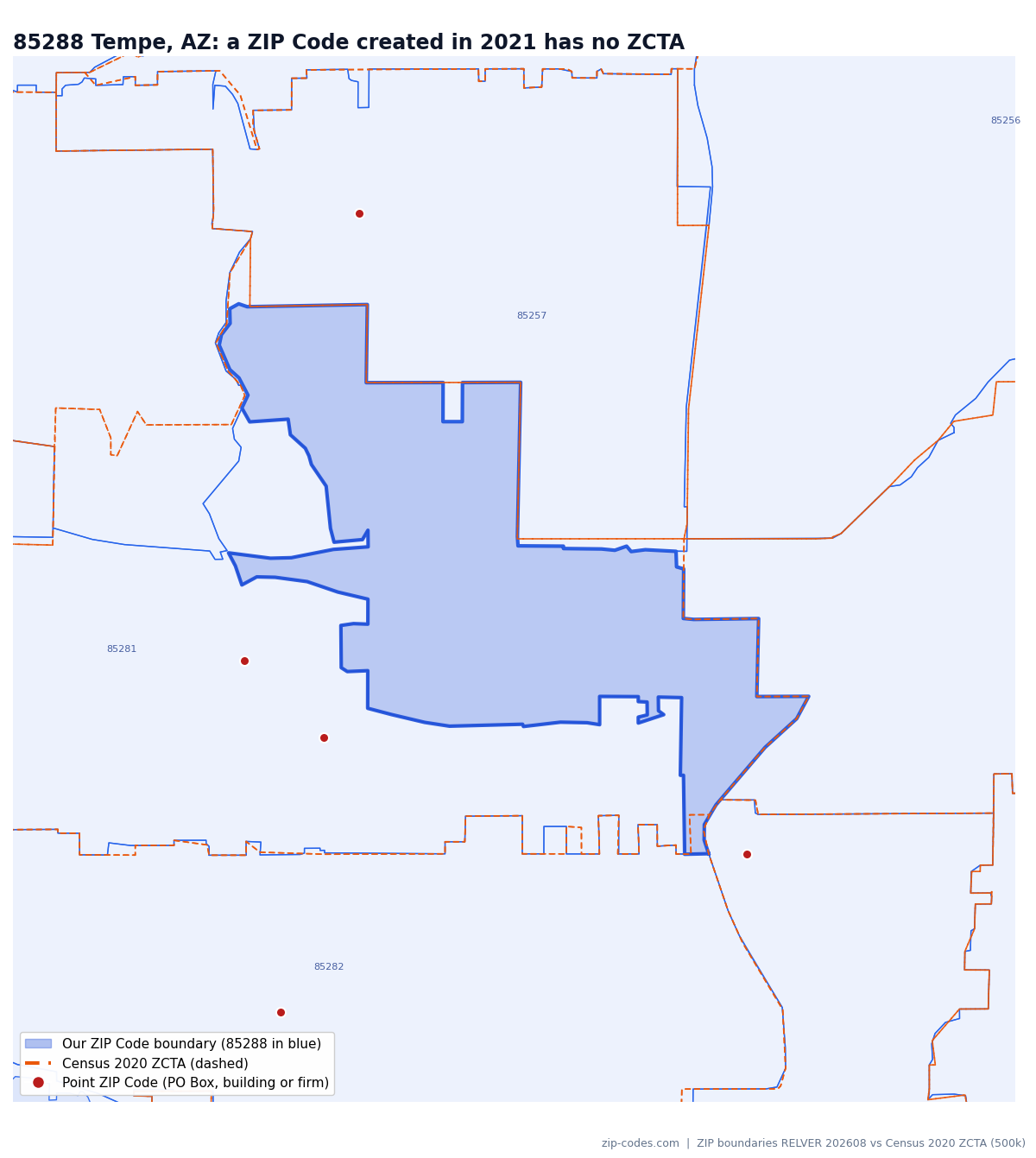
85288, Tempe, Arizona: a ZIP Code absent from the 2020 ZCTA file
85288 was created in 2021 and now has about 12,900 residential and 1,500 business deliveries. In the 2020 ZCTA file, 99.5% of its area belongs to the 85281 ZCTA, so a Census-based map assigns these addresses to 85281 and a lookup for 85288 finds nothing.
Midtown Manhattan: dozens of ZIP Codes that are buildings or PO boxes
61 ZIP Codes in this view are points, not areas: single buildings such as 10118 (the Empire State Building), large firms and banks of PO boxes. 59 of them have no ZCTA. Inside 10001 alone sit 13 of them. In our file each point names the ZIP Code polygon it falls in, so an address file full of building ZIP Codes still lands on the map.
10463, the Bronx: the ZCTA reaches into two other ZIP Codes
As we draw ZIP Code 10463, only 57% of the 10463 ZCTA lies inside it. About 30% falls in 10471 and 11% in 10705 (Yonkers). Much of the difference is Van Cortlandt Park, which our file assigns to 10471. It matters little for population counts, but a point in the park gets a different ZIP Code depending on which file you use.
92562, Murrieta, California: about half the ZCTA falls outside our same-code polygon
The 92562 ZCTA covers a large rural area west of town that our file, following the carrier routes, assigns to 92028 (Fallbrook). As we draw 92562, only 49% of the ZCTA lies inside it; the difference is a modeling choice about rural land as much as a disagreement about addresses. Area-based work such as wildfire or flood exposure by ZIP Code comes out very differently with the two files.


Map data: Zip-Codes.com ZIP Code boundaries, August 2026 release, and U.S. Census Bureau 2020 ZCTA cartographic boundaries (1:500,000). Both are generalized for display and clipped to each view; the product files are full precision. Basemap © MapTiler © OpenStreetMap contributors.
Want this for your own area? The interactive demo adds counties, cities, districts and tracts on top of our boundaries, and every sample comes in all eight formats.
Open the full demo Free samples Price your areaWhich one should you use?
Census publishes its tables by ZCTA, the file is free and public, and a 2020 snapshot is fine for that. Do not use it as a list of current ZIP Codes.
You need the Postal Service’s own polygons USPS ZIP Code BoundariesIf your organization can pay $10,000 or more a year, your use fits the tier you buy, and you are not in the mailing and shipping business (section 9).
You need every civilian ZIP Code in an address file on the map, with delivery counts Our ZIP Code boundariesA single state or a handful of ZIP Codes, SQL-ready formats, and conclusions you can use in your work for customers. We are not the official USPS file, and we do not claim to be, but we have been doing this since 2014.
The same boundaries power our ZIP Code API
If you need answers rather than files, our ZIP Code API runs on these same boundaries for its spatial work, and its address validation tells you the mailing ZIP Code of an address, which no boundary file can.
Validate addresses, not just ZIP Codes
- Check a U.S. street address against USPS ZIP+4 delivery-point data and get back the standardized address, ZIP+4, county and carrier route
- See how much of a ZIP Code lies in each county, city, congressional district and school district
- Radius searches that count a ZIP Code by the share of its area inside the circle
- One address or 250 per call; a free key includes 2,500 credits a day, no credit card
Frequently asked questions
Yes. USPS ZIP Code Boundaries is now sold through PostalPro as an annual subscription with quarterly updates, at $10,000 (Internal), $33,000 (Enterprise) or $150,000 (Publication) a year.
No. A ZCTA is a Census Bureau area built from 2020 census blocks, labeled with the ZIP Code most common among each block’s addresses. Most match a ZIP Code closely, but 18.6% of ZIP Codes in use have no ZCTA, and ZIP Codes created since 2020 are not in the file.
ZCTAs exist only where census blocks have addresses. PO Box, building and single-organization ZIP Codes often have no residential area of their own, military ZIP Codes have no fixed location, and any ZIP Code created after the 2020 delineation does not exist in the file yet.
Not under the Internal or Enterprise licenses. The $150,000 Publication license allows qualitative images, but it lists “interactive applications or visualizations that expose underlying data” as restricted. Read the license before you plan a public map.
Your conclusions, yes: section 5(c) of our license lets conclusions and recommendations drawn from the data form part of your services to customers. The boundaries themselves, and the maps and reports you generate from them, are for internal use only and may not be given to customers, shared or resold.
It depends on the question. Boundaries support area-overlap questions; a single center point supports distance questions. A ZIP Code whose center is just outside a radius can still have much of its area inside it, though neither method alone measures the share of addresses inside. Our radius finder and API can count ZIP Codes by how much of their area falls inside the circle.
No. All three are U.S. files. Our current ZIP Code boundary file covers the 50 states, Washington, D.C., Puerto Rico, the U.S. Virgin Islands, Guam, American Samoa and the Northern Mariana Islands.
Sources and method
- USPS PostalPro: USPS ZIP Code Boundaries, with its briefing sheet, technical guide (Interface Control Document, version 3, April 2026), data license (version April 21, 2026) and order form ZCB001 (September 2026)
- U.S. Census Bureau: ZIP Code Tabulation Areas (ZCTAs)
- Census 2020 ZCTA cartographic boundary file (1:500,000), compared with the Zip-Codes.com ZIP Code boundaries, August 2026 release (RELVER 202608), and our ZIP Code database for November 2026
- Overlap is intersection over union of planar longitude/latitude areas, computed on our full product geometry and the Census 1:500,000 cartographic file (itself generalized) before any display simplification; invalid geometry was repaired with a standard make-valid step. ZIP Codes counted as “in use” are those in our ZIP Code database, one row per ZIP Code. Residential address counts are the delivery counts in our boundary file.
- Zip-Codes.com boundary data license and price calculator
USPS is a registered trademark of the United States Postal Service. Zip-Codes.com is a non-exclusive licensee of the United States Postal Service for some of its ZIP Code data; this page is not endorsed by USPS or the Census Bureau. Last checked November 10, 2026.