From Chaos to Efficiency: Unveiling the Zone Improvement Plan (ZIP) of 1963
When the ZIP Code system was introduced in 1963, it brought improvement in mail processing and delivery efficiency by shortening the steps required to process a piece of mail. Just the ZIP Code alone canceled 6 of the 10 mail routing steps previously used by the USPS. But the USPS had to promote this change heavily to educate customers on how to use it. They faced significant pushback towards adopting it from customers who were hesitant to understand why it was being used. This image is an excerpt from Page 44 of the Lansing State Journal on Sun 16 Jun 1963 in Lansing, MI where the USPS attempts to educcate it's customers on the ZIP Code system.
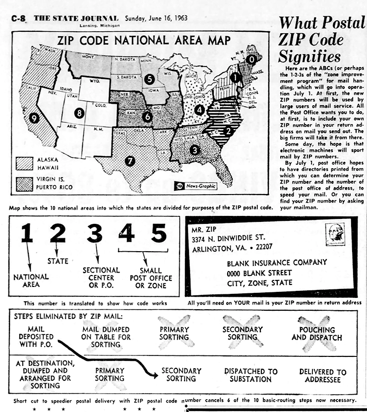
National Areas
The ZIP Code system divided the United States into ten geographic regions called "national areas". These areas were designed to facilitate efficient mail sorting and delivery. Each national area was assigned a specific range of ZIP Codes and was the first number in the ZIP Code.
When the USPS introduced the ZIP Code system in 1963, the ten National Areas and the states included in each area were as follows:
- National Area 0: Northeast Region
- Connecticut (CT), Massachusetts (MA), Maine (ME), New Hampshire (NH), New Jersey (NJ), New York (NY), Pennsylvania (PA), Rhode Island (RI), Vermont (VT)
- National Area 1: Eastern Region
- Delaware (DE), New York (NY), Pennsylvania (PA)
- National Area 2: Southeast Region
- District of Columbia (DC), Maryland (MD), North Carolina (NC), South Carolina (SC), Virginia (VA), West Virginia (WV)
- National Area 3: Great Lakes Region
- Illinois (IL), Indiana (IN), Michigan (MI), Ohio (OH), Wisconsin (WI)
-
National Area 4: Central Region
- Alabama (AL), Florida (FL), Georgia (GA), Kentucky (KY), Mississippi (MS), Tennessee (TN)
-
National Area 5: South Central Region
- Louisiana (LA), Oklahoma (OK), Texas (TX)
-
National Area 6: Great Plains Region
- Iowa (IA), Kansas (KS), Minnesota (MN), Missouri (MO), Nebraska (NE), North Dakota (ND), South Dakota (SD)
- National Area 7: Mountain Region
- Arizona (AZ), Colorado (CO), Idaho (ID), Montana (MT), New Mexico (NM), Nevada (NV), Utah (UT), Wyoming (WY)
- National Area 8: Pacific Region
- Alaska (AK), California (CA), Hawaii (HI), Oregon (OR), Washington (WA)
-
National Area 9: Western Region
- Arkansas (AR), Indiana (IN), Kansas (KS), Kentucky (KY), Missouri (MO), Tennessee (TN)
Five Digits in a ZIP Code: Specific meanings
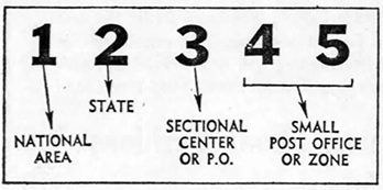
When introduced as a 5 digit number, the different parts of the ZIP Code had very specific meanings
- First Digit: Represented a specific National Area. For example, the Northeastern states fell under the national area represented by ZIP Codes starting with 0.
- Second Digit: Represented a specific State within that national area.
- Third Digit: Identified Sectional Centers or specific Post Offices within that state's national area. These digits helped narrow down the geographic location, usually representing several counties within a state (for lower population areas) or major metropolitan areas.
- Fourth and Fifth Digits: Represented specific post offices or delivery zones within the sectional centers. They provided more precise information about neighborhoods, streets, and areas.
Shortened Routing Steps
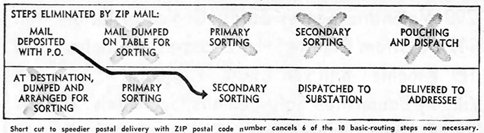
The introduction of ZIP Codes shortened routing steps in mail processing and delivery. Before ZIP Codes, mail sorting was often based on city or postal zone numbers. Introducing the ZIP Code was a more automated way to sort mail, streamlining the routing process, eliminating intermediary steps, and improving accuracy and precision in mail delivery. These advancements significantly reduced the time it took for mail to be processed and delivered, leading to enhanced efficiency within the United States postal system, especially once computerized systems took the place of humans and made the process incredibly fast.
Improved Mail Efficiency in 1963
The ZIP Code system introduced several improvements that enhanced mail efficiency:
- Automated Sorting: ZIP Codes enabled the use of automated machines that read and sorted mail based on the numerical codes. This automation reduced sorting time and increased accuracy, leading to faster processing and delivery.
- Streamlined Routing: With ZIP Codes, postal workers could easily identify the sectional center and delivery zone for each piece of mail. This streamlined the routing process, minimizing the chances of misrouting or delays.
- Standardized Addressing: The introduction of ZIP Codes brought about a standardized format for addressing mail. This standardization ensured complete and accurate address information, reducing errors and facilitating efficient handling.
- Enhanced Tracking: ZIP Codes allowed for better tracking and monitoring of mail. The numerical codes provided data on mail flow, enabling improved accountability and the ability to identify and address any issues or delays in the delivery process.
Changes to the ZIP Code System Today (Compared to 1963)
Since its introduction, the ZIP Code system has undergone some changes to adapt to evolving needs and advancements in technology:
- Expanded ZIP+4: The original five-digit ZIP Code has been expanded to a ZIP+4 format. The additional four digits provide even more precise geographic information, such as specific addresses or building segments within a Sectional Center Facility (SCF) or delivery zone. This increased specificity further enhances mail efficiency.
- ZIP Code Database: The USPS maintains a comprehensive ZIP Code database, continuously updating and refining the information. This ensures accurate and up-to-date routing and delivery.
- ZIP Code Extensions: In certain cases, ZIP Code extensions beyond the standard nine digits are used to represent more specific areas or unique delivery points, such as large organizations or government buildings.
- Delivery Point Barcode: The USPS implemented the Delivery Point Barcode (DPBC) system, which encodes the ZIP Code, ZIP+4, and delivery point information into a barcode. This barcode is used for automated sorting, improving efficiency and accuracy.
- Enhanced Technology: Modern sorting machines utilize advanced optical character recognition (OCR) technology and other automated systems to read and sort mail based on ZIP Codes. This technology has further improved mail processing speed and accuracy.
Overall, the ZIP Code system has continued to evolve and adapt, incorporating technological advancements and refining processes to enhance mail efficiency. These changes have further improved routing accuracy, reduced delivery times, and facilitated better tracking and monitoring capabilities.