Free · no sign-up
Free ZIP Code Lookup and Finder
Look up a ZIP Code, find the ZIP+4 of a street address, or search by city, county or area code.
Look up a ZIP Code, find the ZIP+4 of a street address, or search by city, county or area code.
People, households, income, home values, rent, education and commutes, from the Census Bureau, compared with the nation.
The county, metro area, land area and time zone, and the ZIP Codes next door.
The school district, the public and private schools in the ZIP Code, and colleges close by.
How many businesses and jobs it has, from the Census Bureau’s business counts.
The address the way USPS writes it, with its ZIP+4, carrier route and the kind of delivery.
The county, town, place, census tract and block group the address sits in, each with its FIPS code.
The congressional and state legislative districts, the school district, and the schools in the ZIP Code.
Who lives in the address’s census tract, side by side with the whole ZIP Code, with margins of error.
From your phone’s or computer’s location, or any latitude and longitude you type in.
The closest delivery address or block, and how far it is from where you are.
Census geography, districts, schools and the neighborhood profile, for that address.
Where you are and the nearest address, on a map with ZIP Code boundaries.
Including PO Box, business and military ZIP Codes, each marked so you can tell them apart.
Each ZIP Code’s county and area codes, linked to their own pages.
Leave out the state to see every city with that name, all at once.
When a city has more than one ZIP Code, enter the street address to find the exact one.
Any mix of ZIP Code, city, county, state and area code in one search.
Enter just some of the digits to see every ZIP Code that matches.
Every ZIP Code in a county, with a mark on those whose main county is a neighbor.
Up to 2,000 results, 50 to 100 a page, sorted by any column.
Every ZIP Code in the circle or ring, how far away it is and how much of it is inside, ready to copy or download.
People, households, income, homes, rent, age and commutes for the whole area, from the Census Bureau.
Compare the area with earlier years, in today's dollars.
The straight-line distance in miles and kilometers, the drive with its time, and the compass direction from one place to the other.
Today and when the clocks change, from each place's own rules, so Arizona, Saskatchewan and the Navajo Nation come out right.
County, metro area, area codes, then income, home values, rent, age and commutes from the Census Bureau, with a difference named only when it is real.
Both places, the straight line and the drive on one map, with turn-by-turn directions, ready to print or save as a picture.
The closest U.S. Post Offices to any ZIP Code or city, nearest first, with how far each one is.
Mail processing plants and carrier annexes usually have no public counter. We mark them, so you don't drive to one by mistake.
Directions, the address to copy, and each office on the map, numbered to match the list.
Print the map with its list, or save it as a picture. Hours and services link straight to USPS.
All the ZIP Codes that use an area code, with their cities and states.
The county of each ZIP Code, to see the area an area code reaches.
Each area code links to its own page, and each ZIP Code to its full profile.
Connect Claude or ChatGPT to our ZIP Code data, then ask questions in plain English. No sign-up with us needed.
This sample ZIP Code answers in full without a key. For other ZIP Codes, some details come back as asterisks until you add a free API key.
New to this? We'll walk you through it, one step at a time.
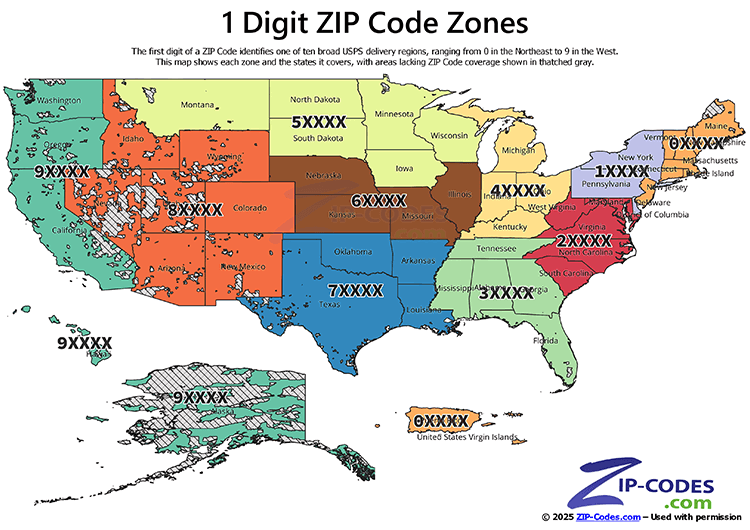
Developer tools: Claude Code, Cursor, VS Code, CodexTen broad postal regions, numbered 0–9 from the Northeast to the West Coast.
The first digit of a ZIP Code represents a group of states. It is the first step in organizing routes for efficient mail delivery: the digits divide the country into ten broad postal regions (0–9) that move roughly from the Northeast (0XXXX) to the West Coast (9XXXX). Each region covers several states, so the first digit of a ZIP Code generally tells you which part of the country it is in.
| 1st digit | States and territories |
|---|---|
| 0 | Connecticut, Massachusetts, Maine, New Hampshire, New Jersey, Puerto Rico, Rhode Island, Vermont, Virgin Islands |
| 1 | Delaware, New York, Pennsylvania |
| 2 | District of Columbia, Maryland, North Carolina, South Carolina, Virginia, West Virginia |
| 3 | Alabama, Florida, Georgia, Mississippi, Tennessee |
| 4 | Indiana, Kentucky, Michigan, Ohio |
| 5 | Iowa, Minnesota, Montana, North Dakota, South Dakota, Wisconsin |
| 6 | Illinois, Kansas, Missouri, Nebraska |
| 7 | Arkansas, Louisiana, Oklahoma, Texas |
| 8 | Arizona, Colorado, Idaho, New Mexico, Nevada, Utah, Wyoming |
| 9 | Alaska, American Samoa, California, Guam, Hawaii, Marshall Islands, Federated States of Micronesia, Northern Mariana Islands, Oregon, Palau, Washington |