Last Updated: May 1, 2025
U.S. ZIP Code Database
ZIP Code Database (5 Digit ZIP Code Database)
- Overview
- Purchase
- Compare
- Redistribution
- Technical Specs
- FAQ
- Tools & Resources
- Why Choose Us?
- Historical
Actual Customer Emails
I appreciate your great customer service and your fine product.Best,
Alan Maitland
Online Yellow Pages
What is a ZIP Code Database?
Our ZIP Code Database is a listing of all U.S. ZIP Code data put into row and column format for easy use and manipulation. With over 90 unique fields of information and every ZIP Code in the United States, it virtually gives you an unlimited number of ways to analyze all the U.S. Census demographic and ZIP Code list information.
Our ZIP Code list is a great tool for marketing, building websites, demographic analysis, store locater, and general analysis.

- Use ZIP Code data for easy lookups and data validation
- Current Population by ZIP Code in our U.S. Business database
- 2020 Census Data included in Deluxe & Business
- All Prices are PER YEAR - Not Monthly/Quarterly
- All purchases come with MONTHLY updates
- Multiple Formats: Access, Excel, CSV, and SQL
|
Multi-County
Edition $189.95/Yr.
Business
|
$89.95/Yr.
Deluxe
|
$49.95/Yr.
Standard
|
|
|---|---|---|---|
| Download Sample | Download Sample | Download Sample | |
| Terms of Service | Terms of Service | Terms of Service | |
| Key Benefits: |
All ZIP Code Databases come with:
|
||
| Data Fields & Columns: | 93 Data Fields 5 Supplemental Files | 60 Data Fields | 31 Data Fields |
| ZIP Code :: 5 digit ZIP Code as designated by the United States Postal Service. U.S. Territories are also included in our ZIP Code Database (Puerto Rico, Guam, American Samoa, Federated States of Micronesia, etc.) 1 |
✓ | ✓ | ✓ |
| City :: The official city name as designated by the United States Postal Service. 1 | ✓ | ✓ | ✓ |
| State :: U.S. two digit Code and Full Name in separate columns. 1 | ✓ | ✓ | ✓ |
| Primary County :: The primary county or parish where the ZIP Code resides as defined by the USPS. As with any of our data fields, you can sort the data by this field and the result will be data grouped by county. For all counties that a ZIP Code may cover, see the All Counties in the Business ZIP Code Database version. 1 |
✓ | ✓ | ✓ |
| Area Code :: Telephone Area Code(s) of the particular postal zone (ZIP Code). Sorting by this field will give you all the data grouped by area code. 2 |
✓ | ✓ | ✓ |
| Classification Code :: The classification type of every ZIP Code. There are 4 different types of classifications and each have its own rules for mail delivery. CODE DESCRIPTION 'Blank' = Non-Unique (Standard ZIP with many addresses assigned to it) M = APO/FPO Military ZIP Code (Military Post Office used for overseas military mail) P = PO Box ZIP Code (Having primarily Post Office boxes) U = Unique ZIP Code (Businesses, government agencies, military, universities, and other entities which receive a large volume of mail.) 1 |
✓ | ✓ | ✓ |
| City Type :: Describes the type of postal station in the 'City Alias' field: CODE DESCRIPTION B Branch C Community Post Office (CPO) N Non Postal Community Name P Post Office S Station U Urbanization X APO/FPO Military Z P.O. Box 1 |
✓ | ✓ | ✓ |
| Latitude & Longitude :: The geographic coordinates of a point measured in degrees north or south of the equator. 2 | ✓ | ✓ | ✓ | Time Zone & Daylight Saving :: Time zone designation within the U.S. Numbers 4-15 are assigned to the time zones (below). A flag also indicates whether the ZIP Code observes daylight saving or not. CODE DESCRIPTION 4 Atlantic (GMT -04:00) 5 Eastern (GMT -05:00) 6 Central (GMT -06:00) 7 Mountain (GMT -07:00) 8 Pacific (GMT -08:00) 9 Alaska (GMT -09:00) 10 Hawaii-Aleutian Islands (GMT -10:00) 11 American Samoa (GMT -11:00) 14 Guam (GMT +10:00) 15 Palau (GMT +9:00) 2 |
✓ | ✓ | ✓ |
| Elevation :: The elevation of this ZIP Code in feet. 3 | ✓ | ✓ | ✓ |
| State & County FIPS :: Federal Information Processing Standards code given to each State or US territory and the County or Parish. 1 | ✓ | ✓ | ✓ |
| State & County ANSI Code :: ANSI code for the State and County this ZIP Code resides in. ANSI is the system that is replacing the FIPS system. 4 | ✓ | ✓ | ✓ |
| Multi County Flag :: Flag indicating whether this ZIP Code crosses county lines. The USPS only designates a 'Primary' county for each record. We use supplemental data to identify those records which actually do cross county lines and indicate that with this field. Full details of all counties covered is provided in the Business ZIP Code Database. 2 | ✓ | ✓ | ✓ |
| City Alias Name & Abbreviation :: The alias name for the ZIP Code as well as abbreviation. This may be a city name, town name, village name, postal entity, community or a municipality name. The city alias names are the reason why our ZIP Code Database has approximately 78,000+ records. There are approximately 41,000 U.S. ZIP Codes, but since we list each city alias within a ZIP Code, we end up with almost double the number of records. 1 |
✓ | ✓ | ✓ | City Alias Code :: Code indicating the type of the city alias name for this record. Record can be Abbreviations, Universities, Government, and more. A = Abbreviation B = Business G = Government M1 = Military Base M1P = Military Base - Primary M2 = Military Non-Base M2P = Military Non-Base - Primary U = University UP = University - Primary Blank = Regular Non Abbreviated ZIP Code 2 |
✓ | ✓ | ✓ |
| Unique ZIP Name :: Field that specifies whether the record contains the organization name for a unique ZIP Code. 1 | ✓ | ✓ | ✓ |
| Primary Record :: This column indicates the 'primary' city name within a given ZIP Code, as designated by the U.S. Postal Service. If you want to get only the 'unique' U.S. ZIP Codes, sort the data by this field. Your results will be all (approx.) 41,000 unique ZIP Codes and all will be designated with a 'P'. 2 |
✓ | ✓ | ✓ |
| Mixed Case City & City Alias :: The USPS designates names in all uppercase (i.e. NEW YORK). The Mixed Case columns provide a proper upper and lower case letters (i.e. New York) spelling. 1 | ✓ | ✓ | ✓ |
| Facility Code :: The type of locale identified in the city/state name. 1 | ✓ | ✓ | ✓ |
| City Delivery Indicator :: Specifies whether or not a post office has city-delivery carrier routes. 1 | ✓ | ✓ | ✓ |
| Carrier Route Sortation :: Identifies where automation Carrier Route rates are available. 1 | ✓ | ✓ | ✓ |
| Finance Number :: A code assigned to Postal Service facilities. 1 | ✓ | ✓ | ✓ |
| Preferred Last Line Key :: Links this record from the ZIP Code Database to other products ZIP-Codes.com offers such as the ZIP+4. 1 | ✓ | ✓ | ✓ |
| City State Key :: A value that uniquely identifies a city state name in City State product. 1 | ✓ | ✓ | ✓ |
| Population :: The population of the ZIP Code based on Census 2020 ZCTA. The population numbers are not projected to the future, they are actual Census 2020 numbers. 5 |
✓ | ✓ | ✗ |
| Population by Race :: The population in each ZCTA for White, Black, Hispanic, Asian, Hawaiian, Indian, and Other racial breakdowns. Based on Census 2020 ZIP Code Tabulation Area. 5 | ✓ | ✓ | ✗ |
| Male & Female Population :: The estimate of Male and Female population per ZCTA based on Census 2020 ZCTA. The Male population numbers are not projected to the future, they are actual Census 2020 numbers. 5 |
✓ | ✓ | ✗ |
| Households per ZIP Code :: Total estimated amount of households per ZCTA based on Census 2020 ZCTA. The households per zip numbers are not projected to the future, they are actual Census 2020 numbers. 5 |
✓ | ✓ | ✗ |
| Persons per Household :: Average number of individuals per household for each ZCTA. 5 | ✓ | ✓ | ✗ |
| Median Avg House Value :: The Median average house value per ZCTA based on Census American Community Survey. Sort by this field to get the top house values by ZIP Code. The Median average house value numbers are from the Census American Community Survey 2017-2021. 6 |
✓ | ✓ | ✗ |
| Median Income Per Household :: The Median average household income per ZCTA based on Census American Community Survey. Sort by this field to get all the top household incomes by ZIP Code. The Median average household income numbers are from the Census American Community Survey 2017-2021. 6 |
✓ | ✓ | ✗ |
| MSA Code & Name :: Metropolitan Statistical Area. (no longer used by government - CBSA is the new standard) MSA's were replaced by CBSA's in the 90's. We keep the old MSA's in our database because some of our older customers use this data and it makes it easier for them if we leave the data in the database. 6 |
✓ | ✓ | ✗ |
| PMSA Code & Name :: Primary Metropolitan Statistical Area. This is the area that the Census Bureau designates as the 'primary' area within a given MSA. 6 |
✓ | ✓ | ✗ |
| CSA Code & Name :: Core Statistical Area. This area is a group of MSA's combined into a population core area. 6 |
✓ | ✓ | ✗ |
| CBSA Data & Name :: Core Based Statistical Area (replaces old MSA's). CBSA data includes the CBSA Code, Name, Type, and Division (if applicable) A Core Based Statistical Area is the official term for a functional region based around an urban center of at least 10,000 people, based on standards published by the Office of Management and Budget (OMB) in 2000. These standards are used to replace the definitions of metropolitan areas that were defined in 1990. A CBSA is broken into two sub categories, Metro and Micro, and are detailed in the CBSA Type Field. These are defined by their population densities. To be considered a Micro area, population must be between 10,000 and 50,000. To be considered a Metro area, population must exceed 50,000. 6 |
✓ | ✓ | ✗ |
| Region & Division:: Region & Division: A geographic area consisting of several States defined by the U.S. Department of Commerce, Bureau of the Census. The States are grouped into four regions and nine divisions. See also: Division 6 | ✓ | ✓ | ✗ |
| Mailing Name :: Yes or No (Y/N) flag indicating whether or not the USPS accepts this City Alias Name for mailing purposes. 1 | ✓ | ✓ | ✗ |
| Current Population :: Exclusively from Zip-Codes.com! This field gives the estimated household population for this ZIP Code for May, 2025. The estimate is derived from known delivery points, household occupancy rates, household size, and more to come up with an accurate estimation for the current population. IMPORTANT: This data does not include population counts for persons in nursing homes, correctional facilities, or other institutions. This is an estimation of the household population based on US Postal Service delivery data. 2 |
✓ | ✗ | ✗ |
| Median Age :: The Median Age for all people per ZCTA based on Census 2020 ZIP Code Tabulation Area. The median age numbers are not projected to the future, they are actual Census 2020 numbers. 5 |
✓ | ✗ | ✗ |
| Male & Female Median Age :: The Median Age for all Males and Females per ZCTA based on Census 2020 ZIP Code Tabulation Area. The median age numbers are not projected to the future, they are actual Census 2020 numbers. 5 |
✓ | ✗ | ✗ |
| # of Businesses :: The total number of Business Establishments for this ZIP Code. Data taken from Business Census 2021. 6 | ✓ | ✗ | ✗ |
| Q1 & Annual Payroll :: The total First Quarter and Annual payroll for this ZIP Code. Data taken from Business Census 2021. 6 | ✓ | ✗ | ✗ |
| # of Employees :: The total number of employees for this ZIP Code. Data taken from Business Census 2021. 6 | ✓ | ✗ | ✗ |
| Employment Flag :: Due to confidentiality, some areas do not have actual figures for employment info. Employment and payroll data are replaced by zeros with the Employment Flag denoting employment size class. CODE EMPLOYMENT SIZE A 0 - 19 B 20 - 99 C 100 - 249 E 250 - 499 F 500 - 999 G 1,000 - 2,499 H 2,500 - 4,999 I 5,000 - 9,999 J 10,000 - 24,999 K 25,000 - 49,999 L 50,000 - 99,999 M 100,000 or more 6 |
✓ | ✗ | ✗ |
| County Growth Rank :: The rank in which this county is growing according to the US Census. Source: Housing Unit Estimates for the 100 Fastest Growing U.S. Counties. Population Division, U.S. Census Bureau. 2 | ✓ | ✗ | ✗ |
| 119th Congressional District :: The 119th Congressional District this ZIP Code is assigned to as well as the approximate land area covered by the district. 1 | ✓ | ✗ | ✗ |
| # Residential & Business Mailboxes :: The number of active Residential & Business delivery mailboxes and centralized units for this ZIP Code. This excludes PO Boxes and all other contract box types. This gives a rough estimate of how many addresses are in this ZIP Code. 1 | ✓ | ✗ | ✗ |
| Land & Water Area :: Two fields that show the approximate amount of land area and water area covered by this ZIP Code in Square Miles. 6 | ✓ | ✗ | ✗ |
| Box Count, SFDU, & MDFU :: Total count of PO Box deliveries, the total count of single family deliveries in this ZIP Code; generally analogous to homes, and the total count of multifamily deliveries in this ZIP Code; generally analogous to apartments. 1 | ✓ | ✗ | ✗ |
| ZIP & Alias Intro Date :: The date the ZIP Code and City Alias name (individually) were introduced by the USPS. 2 | ✓ | ✗ | ✗ |
| SSA State County Code :: The State County Code as set by the Social Security Administration for Medicare and Medicaid. NEW! 7 | ✓ | ✗ | ✗ |
| Medicare CBSA Data :: The CBSA Code, Type, & Name for this ZIP Code as set by the Centers for Medicare and Medicaid Services. NEW! 7 | ✓ | ✗ | ✗ |
| Market Rating Area ID :: The ID of the Insurance Market Rating Area as set by the Centers for Medicare & Medicaid Services. NEW! 7 | ✓ | ✗ | ✗ |
| Also Includes: | |||
| Multi County Data :: This supplemental file/dataset lists all ZIP Codes which cross county lines. It includes the ZIP Code, State Abbreviation & FIPS, and County Name & FIPS. 1 | ✓ | ✗ | ✗ |
| Expanded Census 2010 Data :: The 2010 Census Demographics Summary File 1 dataset for each ZCTA. Topics include Population and breakouts, Age and Sex distribution, Race Composition, Hispanic or Latino Origin, Housing Units, and Relationship to Householder. 8 | ✓ | ✗ | ✗ |
| Expanded Census 2020 Data :: The 2020 Census Demographics DHC dataset for each ZCTA. Total Population: Total population count. Age and Sex: Age and sex distribution within the population, along with different age groups, such as 0-4, 5-9, 10-14, etc. Race: Data on the racial composition of the population, including White, Black or African American, American Indian or Alaska Native, Asian, Native Hawaiian or Other Pacific Islander, and Some Other Race. Hispanic or Latino Origin: The number of individuals who identify as Hispanic or Latino. Housing Units: Data on occupied and vacant housing units. Relationship to Householder: Data on the number of individuals who are householders, spouses, children, siblings, and other relatives. Education Attainment: The number of individuals who have completed different levels of education, such as high school, bachelor's degree, or advanced degree. Median Household Income: Median household income provides income distribution, where half the households earn more and half earn less. All of this and more included the 2020 DP-1 Census data for every ZIP Code. 5 |
✓ | ✗ | ✗ |
| 2019-2023 Census ACS Data :: The 2019-2023 Census American Community Survey (ACS) dataset with 524 fields of data for every ZCTA. Topics include Education, Households, Marital Status, Employment Status, Occupation, Housing Occupancy, Sex and Age, Race, and Voting Age. The ACS data is estimates only and is updated every year. 6 | ✓ | ✗ | ✗ |
| Place FIPS Data :: An additional dataset table lists all ZIP Codes and their associated Place FIPS. Includes ZIP Codes that fall into one or more Place FIPS and allows you to marry ZIP Codes to other datasets that use Place FIPS. 6 | ✓ | ✗ | ✗ |
| Full Database Comparison: | |||
| Full Comparison | Full Comparison | Full Comparison | |
|
Business
$189.95/Yr.
|
Deluxe
$89.95/Yr.
|
Standard
$49.95/Yr.
|
|
| Download Sample Business U.S. ZIP Code Database |
Download Sample Deluxe U.S. ZIP Code Database |
Download Sample Standard U.S. ZIP Code Database |
|
Why trust our ZIP Code Database?
Numerous companies assert their superiority, but few deliver on essential factors. Since our establishment in 2003, we have cultivated an extensive clientele, ranging from Fortune 500 enterprises to individual users and small businesses. Unlike competitors who offer solely email support, we prioritize direct communication, providing a reachable point of contact via phone at 1-800-425-1169. Our unique commitment to an unconditional money-back guarantee underscores our confidence in the unparalleled quality of our ZIP Code Database. We distinguish ourselves not merely as USPS licensees but as direct collaborators, even licensing data back to the USPS. Additionally, we maintain direct partnerships with esteemed data vendors like Precisely. Quality and service stand as our foremost priorities. However, we encourage you to evaluate our merits independently to understand why choosing us is the best decision.
A few customers who use our data


A ZIP Code Database Is A Powerful Tool To Uncover Valuable Info About Your Audience.
The primary objective of any enterprise is to engage with customers who are likely to make a purchase. Do you have a business or are you a developer seeking to integrate ZIP Code-based functionalities into your business applications or projects? Do you want to target specific areas to reach your target audience? The innovative Zip code data allows you to do that. At Datasheet, we offer a US ZIP Code Database for you, so you can target specific areas and reach your target audience. Whether it's for e-commerce, logistics, marketing, or real estate, this ZIP Code database enhances efficiency, accuracy, and user experience.
Datasheer's ZIP Code database enables you to segregate the customer base & figure out those needs and how you can meet them. Different factors will influence clients' buying decisions. A group of higher-income people aren't going to have the same needs as lower-income people. Segregate your customers based on their gender, ethnicity, social class, and economic status, amongst other things. Do you want to figure out the client's wants and needs by breaking down their addressees? Our US Zip Codes Database assists you in identifying your customer base. It will help the developers & business owners tailor their advertising strategy and create content that is more relevant to their customers.
Datasheer's Zipcode Database: Make Your Target Business Add Responsive
Identifying the target market is often the most challenging aspect of advertising. You may have a particular audience you are considering! But then you face difficulties when your advertisements fail to engage that target audience. This may occur if you inadvertently select the wrong demographic or overlook other significant market segments. It is crucial to consider all potential groups when defining your target market. Our US Zip Codes Database helps you identify the audience successfully. It helps you tailor your advertising efforts to meet specific needs.
Zip code targeting presents an excellent opportunity for your business if you aim to reach individuals within a specific geographic region. Utilizing zip code database USPS targeting allows you to determine which areas yield the highest response rates. Our ZIP Code list can be productive in refining your target market further. This approach enables the creation of personalized advertisements that enhance your outreach to the intended audience. Individuals within each zip code can receive messages that are most pertinent to them. It improves engagement and increases the likelihood of business conversion. You may find that a particular zip code is unresponsive then you can easily remove them from your list.
No matter what type of business problem you are facing, we'll provide the most convenient ZIP Code list to address your marketing challenges. Call us now to get the ZIP Code download database package that best fits your business needs!
How recent is your data?
- Updated May 1, 2025
- Updated data published monthly
- Free FTP enables automated updates
In contrast to some providers, we prioritize your needs by releasing our dataset every month. We understand that more than 30 data sources follow various update schedules. Our commitment is to swiftly deliver the latest data to you. In the fast-paced business landscape of today, the timeliness of data is paramount. Keeping your information up-to-date guarantees:
- Accuracy & Quality
- Customer Satisfaction
- Regulatory Compliance
- Operational Efficiency
- Marketing and Targeting
- Competitive Advantage
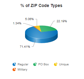
How many ZIP Codes are there?
There are currently 41,552 ZIP Codes actively in service. Of these, 29,796 are Standard ZIP Codes and 9,131 PO Boxes. The USPS has designated 2,032 Unique ZIP Codes for businesses, government, and other special uses. 593 Military ZIP Codes serve our men and women overseas. All versions of our database include all of these records.
9,677 [23.3%] of ZIP Codes cross county lines. The USPS has designated 29,617 city names in and 60,038 city alias names.
How reliable are your data sources?
We source our data exclusively from trusted and authoritative entities, leveraging our two decades of expertise in the field. Our ZIP Code list comes directly from the United States Postal Service (USPS), where we're an accredited distributor. The U.S. Census supplies a majority of our statistical and demographic information. For area code and prefix details, we rely on the North American Numbering Plan Administrator (NANPA). Our CBSA data is obtained straight from the Office of Management and Budget (OMB). Additionally, we collaborate with esteemed data partners like PitneyBowes, USGS, Social Security Administration, and the IRS. Every piece of data we provide is sourced directly from its managing organization, ensuring unmatched accuracy and reliability. Such is our confidence in our data's integrity that we extend an unconditional 30-day money-back guarantee.
Is there an API for the ZIP Code dataset?
Yes! We offer a Free ZIP Code API service as well as paid premium levels. The ZIP Code API includes U.S. ZIP Codes and Canadian Postal Codes. With the API you can build address autocompletion tools, find the ZIP Code of an Address, calculate distances, do radius searches, and get the details of every ZIP Code and Postal Code. The ZIP Code API is a RESTful Service with JSON and XML repsonse formats.
Is there a Free version of your ZIP Code Database?
Yes! We are pleased to provide you with a comprehensive Free ZIP Code Database, encompassing an extensive dataset of seven essential fields for every ZIP Code within the United States. Beyond the availability of this free database, our commitment to empowering users with accessible data extends to our user-friendly website, where you can effortlessly access and explore our extensive ZIP Code information.
Our Free ZIP Code Finder is a versatile tool designed to simplify your search for ZIP Codes, offering multiple intuitive search methods. Whether you are looking to pinpoint a specific ZIP Code, delve into the details of a particular City, County, State, or even Area Code, our user-friendly interface accommodates your diverse needs. You can also perform distance calculations, radius searches and find the ZIP Code of an address, all free.
We recognize that access to accurate ZIP Code information is pivotal for various purposes, from logistics and shipping to market research and location-based analysis. Our Free ZIP Code Database and accompanying tools are designed to empower you with the essential data you need to streamline operations, enhance decision-making, and achieve your objectives with confidence and precision.
Why is this ZIP Code not listed in your database?
"Why is this ZIP Code not listed in your database? We found it in some website or a customer reports it as being valid." We get this question quite a bit and is always investigated to be 100% sure. This ZIP Code used to be valid, but is no longer in service. The USPS revises ZIP Codes to match current delivery needs. ZIP-Codes.com is a licensed distributor of the USPS and only publishes currently active ZIP Codes. Other websites do not adhere to the same data quality standards we do. Customers may have had a ZIP assigned at one time but missed the notification that it has changed.
If you feel a ZIP Code is valid but not listed on our database, you can use the free USPS "Lookup a ZIP Code" to check for yourself at https://tools.usps.com/zip-code-lookup.htm?citybyzipcode. If the USPS reports it as invalid and you believe this is an error, please contact us and we will research it.
Does your ZIP Code Database contain ZCTAs?
No. To explain, you must understand what a ZCTA is. ZIP Code Tabulation Areas (ZCTAs) are generalized area representations of United States Postal Service (USPS) ZIP Code service areas. ZIP Codes are not true areas, but rather a collection of mail delivery routes. They exist solely for the expedient delivery of mail and they change as the needs of the USPS change. Most people think of ZIP Codes as a stable geographic area, but they are not. The U.S. Census aggregates data based on defined geographic regions and cannot use true ZIP Codes as a geographic entity. Thus, ZCTAs were created to differentiate between the U.S. Census region and the USPS true ZIP Code area. They are only changed every 10 years (with a new decennial census release) and diverge from the true ZIP Code area over time.
Many companies will use ZCTA data released by the U.S. Census and claim it as the true ZIP Code Area. They will do this and claim "it's close enough for most needs". ZIP-Codes.com takes data quality seriously, and "close enough" is not good enough. We license the true updated ZIP Code data directly from the USPS and always have the true ZIP Code Boundaries as the changes are made. Some data fields, such as Census Population data, are only available at the ZIP Code Tabulation Area, but these will always be labeled as such.
What Formats are your dataset in?
The ZIP Code Dataset comes in 4 different file types, all available for immediately download. The ZIP Code Database comes in Access, Excel, CSV, and SQL for quick and easy importing into anything you need. For SQL, all table creation scripts are already prepared for you. All formats are freely available to download as many times as needed throughout your 1 year subscription period.
Free FTP Access allows automated delivery every month. Our Free ZIP Code API (or paid separate license) allows programmatic access to the same data with no updates required.
How many types of ZIP Codes are there?
The U.S. Postal Service maintains 4 distinct types of ZIP Codes, known by their Classification Code:
- <BLANK>: Standard. Used for general mail delivery.
- P: P.O. Box. Used primarily for deliveries to contract mail boxes.
- U: Unique. Businesses, government agencies, military, universities, and other entities which receive a large volume of mail.. Ex: Bank of America, Berkeley, IRS.
- M: APO/FPO Military. Used for mail to service men and women stationed overseas.
The ZIP Code Database contains a 'Classification Code' column indicating each ZIP Code type by its letter. This allows you to select only the exact ZIP Code types you need or check if a provided ZIP Code has special limitations (most companies cannot ship to Military ZIP Codes).
ZIP-Codes.com is the ONLY provider that breaks this City Alias Code down further for much better granularity. We take the much broader category of "Unique" and break it down into its smaller pieces of Businesses, Government agencies, or Universities. This breakout allows you to really drill down on every ZIP in the U.S. to know its true purpose.
ZIP Codes are not Geographic Divisions
Most people think of ZIP Codes as the last piece in geographic divisions: Nation > State > County > City > ZIP Code. This is not true. ZIP Codes were created exclusively for the expedient delivery of mail. Mail routes are designed to best suit the needs of the USPS. They change over time. ZIP Codes do not always adhere to national or local geographic boundaries and limits.
ZIP Codes are not required to observe City, County, or State boundaries. To put it in perspective, imagine being a postal employee placing mail in mailboxes down a long street. It would be highly inconvenient to stop and turn around due to an imaginary line such as a county boundary.
ZIP Codes are Not Cities

ZIP Codes have nothing to do with cities. While a ZIP Code has a city name, it is to reference the area it serves. A ZIP Code may also have names for other towns, villages, or well known neighborhoods. For example, ZIP Code 90291 is for Venice, CA. Venice is a residential, commercial, and recreational neighborhood with a statistically significant population of over 28,000 and located within the city limits of Los Angeles, CA. Even the ZIP Code boundary for 90291 does not match the neighborhood boundary for Venice, CA that is generally accepted. It is not possible to compare data for ZIP Code cities with data compiled at the city municipality level, because the boundaries that constrain each are very different.
The map to the left illustrates the disparity between boundaries. Los Angeles City Limits are shown in gray, the Venice Neighborhood Boundary in green outline, and the 90291 ZIP Code Boundary in red.
ZIP Codes that exist outside of city limits will likely have a city name of the larger area that it serves. Towns, Villages, and other well known places might be placed in the City Alias column for identification. Each record has a "MailingName" column that indicates if this name is acceptable for mailing purposes.
Do ZIP Codes Cross County Lines?
Yes. In fact, 23.3% of all ZIP Codes cross county boundaries. Our ZIP Code Database indicates this with the 'Multi County' column. Any ZIP Code marked with a Y value indicates that it covers more than one county. The Business version offers a separate table detailing all counties a ZIP Code covers. The 'primary' county assigned to each ZIP Code is usually based on the part that receives the highest volume of mail. ZIP Codes cross state lines as well if needed, but this is much rarer. As with cities, you cannot compare data for ZIP Codes in a County with County data because the boundaries for each do not match.
What information is included in the Census American Community Survey?
The Census American Community Survey dataset in our Business Database includes over 500 fields of data taken from multiple topics including: Education, Households, Marital Status, Employment Status, Occupation, Housing Occupancy, Sex and Age, Race, and Voting Age.
The American Community Survey (ACS) is an ongoing survey that provides data every year -- giving communities the current information they need to plan investments and services. The ACS covers a broad range of topics about social, economic, demographic, and housing characteristics of the U.S. population.
This data is taken from the 2016-2020 5-Year estimates for each ZIP Code in tables DP02, DP03, DP04, and DP05. Included documentation details the fields available and information about how the data was collected. The 5-year estimates from the ACS are "period" estimates that represent data collected over a period of time. The primary advantage of using multi-year estimates is the increased statistical reliability of the data for less populated areas and small population subgroups.
Why aren't ethnicity populations adding up to the total population for the ZIP Code?
From 1790 to 1950, Census takers themselves determined the race of the Americans they were counting. Those Census takers used their own rules and perceptions to classify Americans into the single racial category they deemed appropriate. Obviously, there were flaws in this approach. Beginning with the 1960 Census, Americans were allowed to choose their own race. There were further changes in the 2000 Census, Americans had the ability to identify with more than one race entirely. The 2010 Census alone had 63 possible race categories. 6 for individual races and 57 for combined races. Over 9 million Americans chose more than one racial category in 2010 alone which was 2.9% of the population.
Because of the multi-racial identification aspect to the Census, the sum of the ethnicities will not equal the total population for a ZIP Code. A person can only be counted once for the total population. If that individual then selected both White and African American, they would then be counted once for each ethnicity. Since the person claiming multiple races is counted twice in the individual racial categories, they would then be counted twice when adding the races together for a sum total. This would not match the actual population due to its counting of that individual only once. The same sum issue applies to all levels of census data (City, County, State).
To learn more about the Census and the Race/Ethnicity questions, please visit https://www.census.gov/programs-surveys/decennial-census/decade/2020/planning-management/release/faqs-race-ethnicity.html
Adding up population, why doesn't it match the total on the Census website?
When you add up the populations for all ZIP Codes, it will not match the national population count. This effect is known and has many reasons why. The primary issue with this method of comparing data is that not everyone lives in a ZIP Code. ZIP Codes are created for the expediate delivery of mail. If a person lives 20 miles from a USPS location in rough terrain, the USPS will not deliver mail to them. The person would essentially live in no ZIP Code at all. The population sum at the ZIP Code level would not count these individuals, but they still exist. Higher demographics levels would be able to include this individual however, such as County and State summary levels.
Another factor affecting the ZIP Code population sum is that the Census does not count incarcerated individuals nor those in nursing homes. These people exist and are counted in population summaries at the County and State level, but they are not always residents of that explicit ZIP Code. Hispanic is also not a race, it is an ethnicity. Individuals who select Hispanic on the Census Survey are also asked to check their race separately.
References
- U.S. Postal Service [Last Updated: 5/1/2025], https://www.usps.com
- ZIP-Codes.com Internal Data Creation [Last Updated: 5/1/2025], https://www.zip-codes.com
- U.S. Geological Survey [Updated as needed], https://www.usgs.gov
- U.S. Census American National Standards Institute (ANSI) [Last Updated: 5/1/2025], https://www.census.gov
- U.S. Census 2020 [Decennial] [Last Updated: 5/25/2023], https://www.census.gov
- U.S. Census [Updated Yearly], https://www.census.gov
- Centers for Medicare & Medicaid Services [Updated Yearly], https://www.cms.gov
- U.S. Census 2010 [Decennial] [Last Updated: 1/1/2010], https://www.census.gov
Portions of data provided by and © United States Postal Service 2025. Zip-Codes.com is a non-exclusive licensee of the United States Postal Service.

