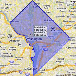
Carrier Route Boundary Data
Carrier Route boundary data shows direct marketers where their prospects live, helping them to develop efficient strategies and target campaigns and help web developers add relevance to search capabilities. Carrier Route Boundaries also allow local search by ZIP Code to display an area on a map with points of interest. Of course, the more accurate the ZIP Code data, the better the marketing and search results.
Are you using old USPS data? How much are inaccuracies costing your business? ZIP-Codes has the most accurate USPS and GIS data available. We build ZIP Codes from the individual address up and align boundaries with streets to represent on-the-ground reality. And, we keep Carrier Route data up-to-date with the frequent changes driven by USPS expansions and consolidation.
It's tempting to cut corners on the complex processing of millions of addresses in the United States, but we never do. Instead, data and GIS experts apply strict methodology to ensure that every 5 digit ZIP Code, along with ZIP+4 Codes, accurately directs business investments.
More Information
For more information on our Code Map Boundary Data, please visit our desktop page.
Visit Desktop PageAvailable Data Formats
- ESRI - Shapefile (.shp)
- Google Display - KML (.kml)
- DB Loadable - WKT (.txt)
- DB Loadable - MySQL™ (.sql)
- DB Loadable - Post GIS (.sql)
- ^^ You get all these!
Data Fields:
You get more than just the boundary data. These are just some of the data fields also included:
- Name
- Carrier Route ID
- ZIP Code Type
- State
- County
- State/County FIPS
- Centerpoint Lat/Lon
- Residential Delivery Count
- Business Delivery Count
- P.O. Box Delivery Count
- Single Family Delivery Count
- Multi Family Delivery Count
- Color (for easy mapping)
Instant Quote
Get an instant quote online. Use our Real Time Quote engine to see exactly what your data will cost and purchase only the areas you need. Plus, your files are ready for download instantly after purchase.
Get Instant Quote
