50 State CD of U.S. ZIP Code Maps
Product Discontinued
This Product has been Discontinued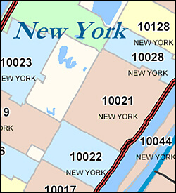
Benefits & Features
- Fast Delivery: All 52 maps are loaded into your account AND the CD is shipped priority mail by the next business day.
- 50 + 2 States: Our 50 State CD comes with a map for each state in the US as well as Washington D.C. and Puerto Rico. All for less than $8 per state.
- Current Data: Using old data leads to costly mistakes and we update our ZIP Code Maps every month.
- Easy to Read: Highways and multi-colored shading make finding the ZIP Codes you are looking for simple.
- Clear Boundaries: Maps show ZIP Code boundaries, county boundaries, postal town names and highways. ZIP Codes assigned to single institutions or companies and those made up of PO Boxes only are not shown on the map.
- 5 Digit ZIP Code: Our maps show the boundaries for the full 5-Digit ZIP code.
ZIP Code Map Specifications, Format and Print Sizes
- All maps are provided electronically in PDF format with an image size of at least 2'x3' up to 6'x6'.
- Maps for CA, TX, FL, NY, PA, and MI come in two-page map format because of size.
- These maps are intended for digital use but may be printed for wall maps using your own wide-format printer or taken to a printing shop such as Kinkos.
- The size of each ZIP Code State Map is given below. For states that require two pages, each page is the size listed.
Purchase Agreement for ZIP Code Maps
By purchasing a map, you agree to the following:
- Each map will include ZIP Code boundaries, county boundaries, and highways.
- All ZIP Code areas will be outlined and labeled with the 5-digit ZIP code. The USPS changes ZIP code areas frequently: our data is updated monthly. Minor discrepancies may occur.
- ZIP Codes will be shaded in one of 5 colors, for easier differentiation between nearby ZIPs.
- Where possible, ZIP codes will also be labeled with the city name
- Box-level or "point" ZIP Codes will not appear.
- Some labels may overlap.
- County areas will be outlined and labeled.
- Highways will be colored red or black and labeled with appropriate shields. In cases where a highway changes into a non-highway classified road, the highway may appear to "end".
- For maps of entire states only: Insets for high density areas will be provided as appropriate.
- The map legend will include symbols, colors, and labels for all map elements. We reserve the right to modify styles as appropriate to achieve the best cartographic representation.
- Each map will include information and any applicable copyright notices. Any duplication, digital or paper, in whole or in part must retain this information.

