Use what works for your workflow. Every purchase includes all formats - no extra charge, no complicated conversions.
.shp + bundle
Industry-standard GIS format. Compatible with ArcGIS, QGIS, and MapInfo.
.geojson
Modern web mapping format. Perfect for Leaflet, Mapbox, and web applications.
.sql
Microsoft SQL Server geography type with SRID 4326.
.sql
PostgreSQL spatial extension import script.
.sql
MySQL and MariaDB geometry import script.
.kml
Google Earth and visualization format.
.txt
Well-Known Text format for custom database imports.
.csv
Attribute data for spreadsheet analysis.
All formats included with every purchase. Choose what works for your workflow-no extra charge, no format conversions needed.
Select the number of users who will be using this data, then choose your geography. You can select national coverage (all ZIP Codes), a single state, or up to 65 specific ZIP Codes.
Complete boundary and centroid datasets with everything you need for professional GIS mapping and analysis.
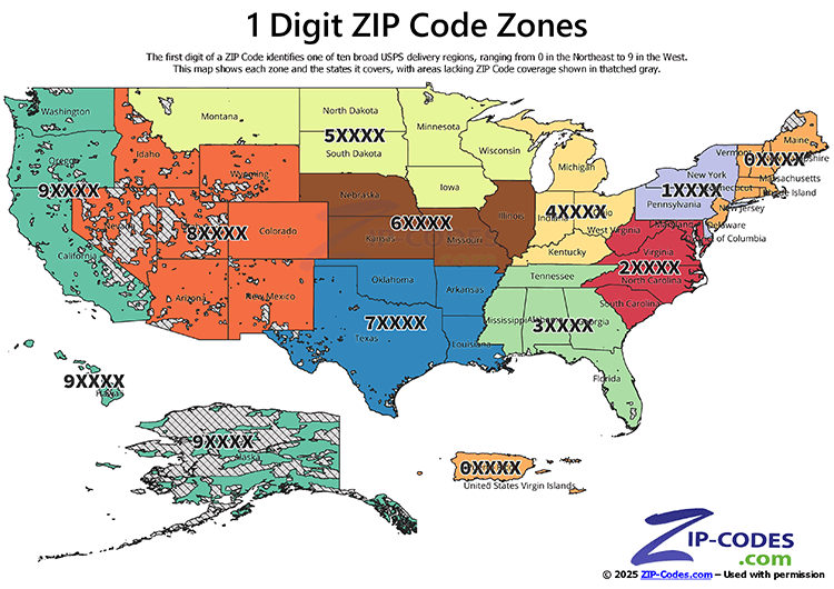
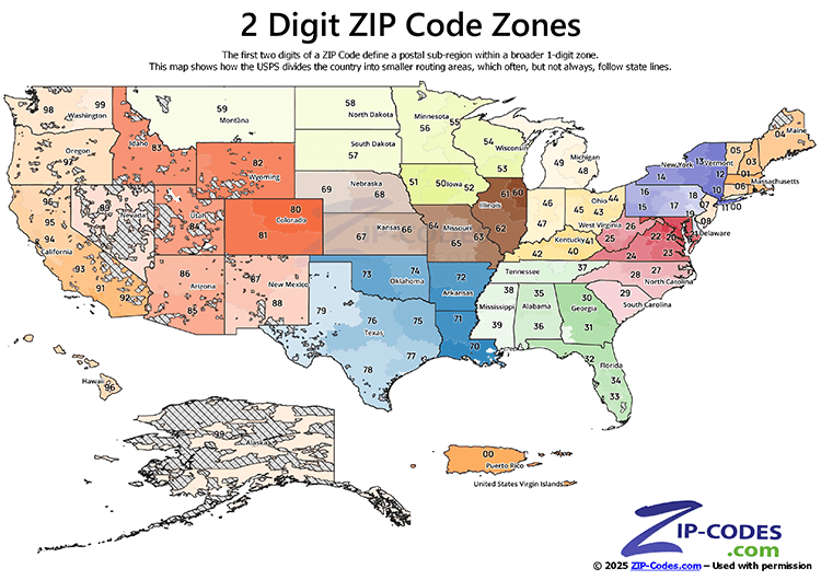
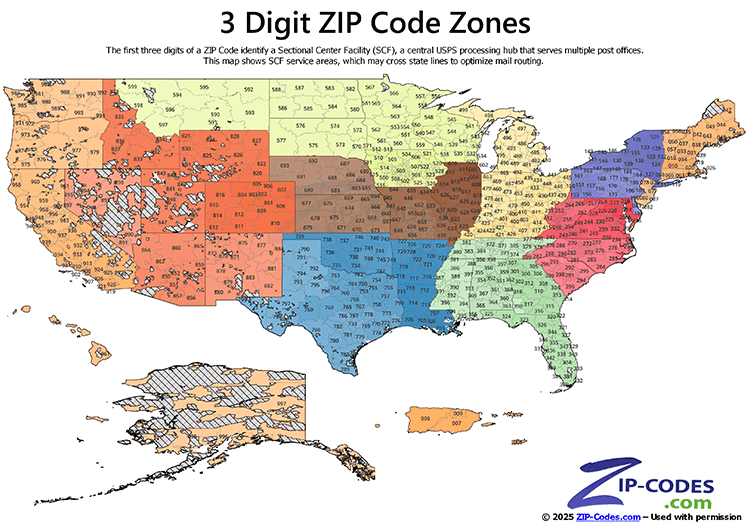
These professional zone maps were built using our ZIP Code Boundary Data. Explore how boundaries organize the U.S. postal system from national regions to detailed sectional facilities.
These maps demonstrate the quality and precision of our boundary data. Create your own visualizations with the same professional-grade datasets.
Click any ZIP Code boundary to view its complete attribute data. This interactive map demonstrates the precision and detail of our boundary dataset using a sample of the San Francisco Bay Area.
Explore ZIP Code boundaries for the San Francisco Bay Area. Click any boundary to see complete attribute data including demographics, county information, and geographic details.
Click on any ZIP Code boundary to view detailed information including ZIP code, name, type, state, county, coordinates, and demographic data (residential count, businesses, housing units).
Showing sample ZIP Code boundaries for the San Francisco Bay Area (San Francisco, Alameda, Marin, and San Mateo counties). Download complete sample datasets with hundreds of ZIPs in all 8 formats.
Real-world applications for professionals across industries. From territory planning to healthcare analytics, our boundary data powers critical business decisions.
Define precise sales territories, service areas, and operational zones using accurate ZIP Code boundaries. Visualize coverage gaps, balance workload distribution, and optimize resource allocation across your geographic regions.
Overlay demographic data, customer locations, and competitor presence on accurate ZIP boundaries. Identify high-value markets, analyze penetration rates, and discover growth opportunities with comprehensive market intelligence.
Optimize delivery routes, warehouse placement, and last-mile logistics using precise ZIP boundaries. Calculate service coverage areas, estimate delivery times, and identify the most efficient distribution points for your network.
Map patient catchment areas, analyze healthcare service accessibility, and plan facility locations for equitable coverage. Identify healthcare deserts, model drive-time isochrones, and ensure communities have access to critical medical services.
Ready to put our boundary data to work for your organization?
Quick answers to common questions about our ZIP Code Boundary Data. Have technical questions? See the full Technical FAQ.
Pricing varies by license tier (Single User to Unlimited) and geography (National, Single State, or Custom ZIPs up to 65). Use our pricing calculator to get instant pricing for your specific needs. National licenses start in the low thousands, while single-state and custom ZIP options offer more affordable entry points for regional applications.
Yes! We offer four free sample datasets in all eight formats:
Each sample includes all 8 formats (Shapefile, GeoJSON, SQL Server, PostGIS, MySQL, KML, WKT, CSV). Visit our Technical Specs page to download samples.
Every purchase includes:
Department and Enterprise licenses include priority support. Enterprise licenses (50+ users) also include phone support and dedicated account management.
Licenses are based on the number of named users within your organization. You can use the data in commercial applications, create derived visualizations and reports, and integrate it into your software-but you cannot redistribute or resell the raw boundary files.
Allowed: Territory maps for clients, market analysis reports, web applications showing coverage areas, internal GIS projects.
                                    Not Allowed: Repackaging and selling raw boundary files, sublicensing to third parties.
                                    Contact us if you have specific questions about your use case.
All data uses WGS84 datum (SRID 4326) with longitude-latitude axis order, making it compatible with web mapping libraries (Leaflet, Mapbox) and most GIS software. Coordinates are stored with 6-7 decimal places for high precision. For distance and area calculations, you may want to project data to an appropriate UTM zone or state plane coordinate system.
Centroid files include all ZIP Codes (~33,000 records), including PO Box and Unique ZIP Codes that don't have street delivery areas. Boundary files only include polygonal ZIP Codes (~41,000 records) with geographic extent. Use boundaries for mapping and spatial analysis; use centroids for geocoding, distance calculations, and point-in-polygon queries.
Yes, some ZIP Codes serve areas in multiple states. These are represented as single polygons and assigned to the state used in their mailing address, not the state where their centroid falls. This ensures ZIP Codes align with USPS addressing conventions.
Filler ZIP Codes are synthetic ZIP Codes (###MH for water, ###MX for land) that ensure 100% continuous national coverage with no gaps or holes. They represent areas where USPS does not provide mail delivery-remote wilderness, large water bodies, national parks, military reservations.
These fillers eliminate map gaps and ensure clean topology for spatial analysis. They always have zero population and zero delivery counts. Filler ZIPs are clearly marked in the ZIPTYPE field as "FILLER" so you can filter them out if needed.
Data is built from USPS monthly carrier route updates and released quarterly, typically within one month of the source data. The RELVER field in each record indicates the exact data vintage (e.g., 202508 = August 2025 release). Quarterly updates include new ZIP additions, retired ZIP removals, boundary adjustments, and demographic count updates.
Yes! Our data is compatible with all major GIS platforms:
Visit our Technical Specs page for detailed import instructions and code examples for each platform.
Boundaries are derived from USPS carrier route data and aligned to Census TIGER/Line street centerlines, typically accurate to within 50-100 meters in urban areas. Rural and less-populated areas may have slightly lower precision due to sparser address points. Coordinates are stored with 6-7 decimal places (~10cm precision), which is more than sufficient for ZIP-level mapping and analysis. This is NOT parcel-level precision-boundaries represent mail delivery areas, not legal property lines.
No! Our proprietary process includes filler ZIP Codes (###MH for water, ###MX for land) to ensure 100% continuous coverage of the United States. This eliminates map gaps in areas without USPS delivery service-like remote wilderness areas, large lakes, military reservations, and national parks. Filler ZIPs are clearly marked in the ZIPTYPE field so you can filter them if needed, but they ensure clean topology and edge-to-edge coverage for professional cartography.
New releases are published quarterly (every 3 months) based on monthly USPS carrier route updates. Each purchase includes one year of quarterly updates. Download links for new releases are automatically emailed to licensed users. After the first year, you can renew for continued updates or keep using your last downloaded version indefinitely-no recurring fees required to use data you've already downloaded.
Download links for quarterly updates are emailed to licensed users automatically when new releases are published. Your account access remains active for your license period (typically one year). You can download updates as many times as needed during that period. After your license expires, you retain permanent rights to use all versions you downloaded during the active period.
Yes. ZIP Code boundaries can shift due to USPS route realignments, new housing developments, Census updates, or changes in mail delivery patterns. Most changes are minor boundary adjustments, but occasionally ZIP Codes are split, merged, or retired entirely. Quarterly updates ensure you have current boundaries that reflect the latest USPS carrier routes. Historical versions are available upon request if you need to analyze changes over time.
James Harris
Lead Data Architect - 23 Years Experience
Good data doesn't just happen - it takes real people who care about getting things right. James and our team manually verify every source. No running scripts and calling it done. We maintain high standards because you're counting on this data to run your business.
When something doesn't look right, we dig into it. That's the difference experience makes.
More About Our Team →
                    Our mission: Provide the most accurate, comprehensive, and trustworthy ZIP Code data in the industry - so you can make confident business decisions based on reliable intelligence.
Since 2003, we have maintained 99.9% accuracy through rigorous verification, expert curation, and committment to data quality.
We believe that good data matters, and so does good service. When you need help, you'll talk to an actual person - not a ticket system or an endless email thread. Call us and we'll pick up the phone. Email us, and we will respond promptly. It's a simple thing, but it makes a difference when you're on a deadline or troubleshooting an issue.


                Our sources include trusted federal and licensed data from the United States Postal Service, U.S. Census Bureau, U.S. Geological Survey, and Centers for Medicare & Medicaid Services, along with proprietary datasets created by ZIP-Codes.com. Data last updated on November 3, 2025.