ZIP Code List & Demographics Database Download: Digital ZIP Code Database & Maps

1-800-425-1169
 

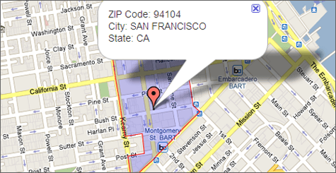
FREE ZIP Code Finder
Enter ZIP Code:

*Find Info on any U.S. ZIP Code
Find ZIP of Address
Address(U.S.):
Town/City:
State:
 

*Find the ZIP Code, county, and +4 of any U.S. Address
Other FREE Lookups
Town/City:
State:
County:
Area Code:
 

*Lookup ZIP Code of any city, state, county or area code
FREE Radius Search
Find all ZIP Codes

Between
And
of ZIP Code:
 

» Download the FREE Radius Finder Application

FREE Distance Calc
Calculate the distance between two U.S. or Canadian ZIP codes.

Start ZIP:
End ZIP:


ZIP Code Boundary Data

Questions? 1-800-425-1169


Questions?
  • Questions? 1-800-425-1169

Available Data Formats:
  • ESRI - Shapefile (.shp)
  • Google Display - KML (.kml)
  • DB Loadable - WKT (.txt)
  • DB Loadable - MySQL™ (.sql)
  • DB Loadable - Post GIS (.sql)
  • ^^ You get all these!
  • Download Sample

Real Pricing + Instant Download:

Get an instant quote online. Use our Real Time Quote engine to see exactly what your data will cost and purchase only the areas you need. Plus, your files are ready for download instantly after purchase.

Get a Quote & Purchase


Features:
  • Enhanced USPS data
  • Boundary Polygon + Centroid
  • Comprehensive national coverage
  • Strict methods to align with streets and eliminate overlaps
  • Updated Every Quarter
  • All Features

ZIP Code boundary data shows direct marketers where their prospects live, helping them to develop efficient strategies and target campaigns and help web developers add relevance to search capabilities.  ZIP Code Boundaries also allow local search by ZIP Code to display an area on a map with points of interest.  Of course, the more accurate the ZIP Code data, the better the marketing and search results.

Are you using old ZIP Code data?  How much are inaccuracies costing your business?  ZIP-Codes has the most accurate ZIP Code GIS data available. We build ZIP Codes from the individual address up and aligns boundaries with streets to represent on-the-ground reality. And, we keep ZIP Code data up-to-date with the frequent changes driven by USPS expansions and consolidation.

It’s tempting to cut corners on the complex processing of millions of addresses in the United States, but we never do. Instead, data and GIS experts apply strict methodology to ensure that every 5 digit ZIP Code, along with ZIP+4 Codes, accurately directs business investments.

Available Data Formats:
  • ESRI - Shapefile (.shp)
  • Google Display - KML (.kml)
  • DB Loadable - WKT (.txt)
  • DB Loadable - MySQL™ (.sql)
  • DB Loadable - Post GIS (.sql)
  • ^^ You get all these!
  • Download Sample

Data Fields:

You get more than just the boundary data. These are just some of the data fields also included:

  • Name
  • ZIP Code Type
  • State
  • County
  • State/County FIPS
  • Centerpoint Lat/Lon
  • Residential Delivery Count
  • Business Delivery Count
  • P.O. Box Delivery Count
  • Single Family Delivery Count
  • Multi Family Delivery Count
  • Color (for easy mapping)
  • See More

Real Pricing + Instant Download:

Get an instant quote online. Use our Real Time Quote engine to see exactly what your data will cost and purchase only the areas you need. Plus, your files are ready for download instantly after purchase.

Get a Quote & Purchase


Features

ZIP Code boundaries add perspective to your maps, point you toward the good potential customers, and add relevence to your local search.

ZIP Code Boundaries are:

  • Available to download immediately. Working on a Saturday and need this data right now? No problem!
  • Sourced from the USPS, then enhanced and improved using proprietary processes.
  • Compiled with strict methodology and algorithms that align ZIP Code data with streets to eliminate overlaps.
  • Comprehensive, providing coverage across the entire United States including Washington DC and Puerto Rico.
  • Complete with latitude/longitude for all ZIP Code polygons, and ZIP Code centroids.
  • Easy to integrate with other datasets including Neighborhood Boundaries, County Boundaries, City Boundaries, and other GIS databases.
  • Updated and released every quarter.
  • Available in multiple major GIS formats:
    • ESRI - Shapefile (.shp)
    • Google Display - KML (.kml)
    • DB Loadable - WKT (.txt)
    • DB Loadable - MySQL™ (.sql)
    • DB Loadable - Post GIS (.sql)

Use ZIP Code Boundaries:

  • See customer data with actual boundaries for the ZIP Code also shown.
  • Include in your own web mashup or interactive map application on the web.
  • Use for lead assignment or for routing leads to sales reps or distributors.
  • Add ZIP Code layers to your existing Geographic Information System (GIS) such as ESRI's ArcView or MapInfo.
  • Internal data analysis of customers, vendors, or any segment imaginable.
  • Real ZIP Code boundaries, not a ZIP Code Tabulation Area (ZCTA) like most sites provide from the Census Bureau.


ZIP Code Boundary FAQs

What SRID/Datum is Used?

All of our boundary data uses SRID 4326 or WGS84.

How is ZIP Code GIS data created?

Using sophisticated algorithms that strictly interpret monthly data feeds from the US Postal Service, Maponics ZIP Code GIS data is built from the address up to represent on-the-ground reality. Each Maponics ZIP Code boundary is closely tied to the street network as defined in the TIGER/Line® street data network.

Why do ZIP Code boundaries have to be updated?

There are about 45,000 5-digit ZIP Codes in the US. The exact number changes frequently. Most of those changes are quite small. Others are significant.

ZIP Codes change for two reasons: population growth requires adding ZIP Codes or ZIP Codes are reorganized to facilitate mail delivery.

How much of the country does Maponics ZIP Code data cover?

Maponics ZIP Code GIS data covers the entire United States.

Doesn't the USPS make ZIP Code maps?

No. ZIP Code maps are not made with polygons but with collections of deliverable addresses. Boundaries have to be created using those address clusters and given latitude and longitude coordinates. This is an extensive process that falls outside the mission of the USPS. In fact, USPS.com refers all visitors looking for ZIP Code maps to Maponics.

In what ways are Maponics ZIP Codes more accurate than other ZIP Code datasets that are available?

The enormous effort and amount of resources required to create accurate ZIP Codes often entices companies to take short-cuts. The fact is that some ZIP Codes are easy to map and others are difficult in that they require thought and research. Many data providers over-generalize boundaries by simply dropping ZIP Codes that are hard to map.

We never takes those short-cuts. Strict data methodologies and quality assurance checks ensure that ZIP Code Boundaries accurately capture all ZIP Codes, not just those that are easy to map.

What is a ZIP Code?

ZIP is an acronym for Zone Improvement Plan, and refers to the USPS’ initiative in the 1960’s to improve the sorting and delivery of mail. Units with roughly the same number of deliverable addresses were created and termed ZIP Code.

ZIP Codes are comprised of 5 numbers. An additional four, referred to as ZIP +4, are appended by the USPS to allow mail to not only reach the postal town associated with a ZIP Code but also be sorted to the level of city block, office building, or individual high-volume receiver of mail.

Why are there filler ZIP Codes? How can they be used?

Filler ZIP Codes are utilized by us to help create continuous polygonal ZIP Code coverage across the United States in places where there isn't sufficient information to define a ZIP Code point or polygon. Filler ZIP Codes can be used for display purposes so that visually there are no holes. Filler ZIP Code structure is as follows: a 3-digit ZIP Code followed by either an "MH" or "MX" (ex. 901MH) to differentiate areas encompassed by water (MH) or land (MX).

Can ZIP Codes cross state boundaries? If so, how are the polygon represented in this product? Is the same true for county boundaries?

ZIP Codes can cross state boundaries. In our ZIP Code Boundaries product these ZIP Codes are represented as one polygon and are assigned to the state where the centroid of the ZIP falls. The same is true for ZIP Codes that cross county boundaries.

Why do some ZIP Codes have multiple polygons?

ZIP Code data is not really polygonal. ZIP Code data can be non-contiguous pockets of addresses served by a specific zip code. Additionally, topological features such as water (a bay or river - especially with islands) or mountains can create address pockets. ZIP Codes are created solely for the purpose of efficient mail delivery which results in these kinds of quirks and oddities.

ZIP Code Boundaries Sample


Includes these data formats:
  1. ESRI - Shapefile (.shp)
  2. Google Display - KML (.kml)
  3. DB Loadable - WKT (.txt)
  4. DB Loadable - MySQL™ (.sql)
  5. DB Loadable - Post GIS (.sql)

ZIP Code Boundaries Specifications

Field Name Data Type Description
geom** GEOMETRY Binary internal representation of geometry
WKT* TEXT “MULTIPOLYGON” label, followed by coordinate pairs to define polygon(s) (longitude, latitude)
ZIP Char(5) 5-digit ZIP Code
NAME VarChar(40) Postal town name, Primary
ZIPTYPE VarChar(20) The type of ZIP Code, per one of three types: NON_UNIQUE, PO_BOX, or UNIQUE
STATE Char(2) State abbreviation (see note #2 below)
STATEFIPS Char(2) State FIPS Code
COUNTYFIPS Char(3) County FIPS code
COUNTYNAME VarChar(60) County name
S3DZIP Char(3) 3-digit ZIP Code (the first 3 digits of the 5-digit ZIP Code)
LAT Decimal(12, 6) Latitude of ZIP Code Centroid
LON Decimal(12, 6) Longitude of ZIP Code Centroid
EMPTYCOL VarChar(5) Empty record
TOTRESCNT Integer Total count of residential deliveries in this route
MFDU Integer Total count of multifamily deliveries in this route; generally analogous to apartments
SFDU Integer Total count of single family deliveries in this route; generally analogous to homes
BOXCNT Integer Total count of PO Box deliveries in this route
BIZCNT Integer Total count of business deliveries in this route
RELVER VarChar(8) Release version (e.g. 1.11.1)
COLOR Integer Numeric value for colorization in a map, so that no two adjacent ZIP Codes have the same color

*WKT field only in WKT format file
**geom field only in MySQL™ and PostGIS formats

Note #1: For database loadable formats all field names will be lowercase
Note #2: In rare instances, ZIP Code boundaries can cross state borders, in which case the state recorded is where the ZIP Code centroid falls.


Customer Uses

Real Time Quote
Please Select Geographies

List Tools

0
ZIP Code(s)
Build your list by entering ZIP Code(s) or ZIP Code Ranges

0
Cities
Build your list by selecting specific Cities

0
Counties
Build your list by selecting State & Counties

0
Area Code(s)
Build your list by selecting Area Code(s)

0
States
Build your list by selecting full State(s)

0
CBSA's
Build your list by selecting specific CBSA's

0
ZIP Code Radius
Build your list by generating a radius around a location


Quick Quote Management

Please enter/select geography locations to narrow your search down.